Arrowtown is a historic gold mining town in the Otago region of the South Island of New Zealand. Arrowtown is located on the banks of the Arrow River approximately 7.5 km from State Highway 6. Arrowtown is located 19.5 kilometres to the east of Queenstown. As well as the route via State Highway 6 at Arrow Junction, there is also road access directly to Queenstown via Arthurs Point and a third route via the picturesque Lake Hayes.

Fairlie is a Mackenzie District service town located in the Canterbury region of the South Island of New Zealand. The estimated population was 950 as of June 2023. Being on state highway 8 between Christchurch and Queenstown, tourism is fast becoming a major industry within the town. Kimbell is 8 km west of Fairlie via state highway 8. Geraldine is 45 km east via state highway 79 and Timaru is 58 km southeast of Fairlie via state highway 8. Fairlie sits at an altitude of 301 metres above sea level.

Te Anau is a town in the Southland region of the South Island of New Zealand. In Māori, Te-Anau means the Place of the Swirling Waters. It is on the eastern shore of Lake Te Anau in Fiordland. Te Anau is 155 kilometres north of Invercargill and 171 kilometres to the southwest of Queenstown. Manapouri lies 21 kilometres to the south. Te Anau lies at the southern end of the Milford Road, 117 kilometres to the south of Milford Sound.

Berhampore is a suburb of Wellington, New Zealand. It lies towards the south of the city, four kilometres from the city centre, and two kilometres from the coast of Cook Strait. It is surrounded by the suburbs of Vogeltown, Newtown, Melrose, Island Bay, Kingston, and Mornington. The suburb was named after Berhampore in Bengal, one of the battlefields at the start of the Battle of Plassey of 1757. Also surrounding Berhampore is the Berhampore Golf Course as well as a very extensive green belt with many walkways and tracks connecting outlying areas. The suburb also boasts some of Wellington's best all weather sports fields, on Adelaide Road and the national hockey stadium. Alongside the golf course there is a skateboard/bmx park, right by a kids mountain bike track. Berhampore School opened in 1915.

Glenorchy is a small settlement at the northern end of Lake Wakatipu in the South Island region of Otago, New Zealand. It is approximately 45 km (28 mi) by road or boat from Queenstown, the nearest large town. There are two pubs, a café and a range of small shops in the town catering mainly to tourists but also to the small resident population. There is also a small airstrip which caters to small planes.
Kingston is a small town at the southernmost end of Lake Wakatipu, just north of the border of Otago and Southland, in New Zealand's South Island. It is 47 kilometres south of Queenstown by a road, "The Devil's Staircase", which winds between the lake to the west and The Remarkables mountains to the east. It is 70 kilometres north of Lumsden, and close to the headwaters of the Mataura River.

Queenstown-Lakes District, a local government district, is in the Otago Region of New Zealand that was formed in 1986. It is surrounded by the districts of Central Otago, Southland, Westland and Waitaki.
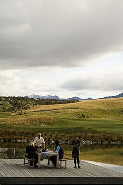
The Wakatipu Basin is a plain surrounded by mountains in Queenstown Lakes District, in the southern South Island of New Zealand.

Carters Beach is a suburb of Westport on the West Coast of New Zealand's South Island. Located 6 kilometres (4 mi) west of Westport on State Highway 67A, it offers a pristine sheltered sandy beach on the West Coast suitable for swimming. From the Buller River jetty at the east end of Carters Beach, west to Cape Foulwind, the beach runs for more than 9 uninterrupted kilometres.
Tahuna is a small rural settlement located 18 km north of Morrinsville. In the Māori language Tahuna means sandbank, likely to refer to the sandbanks along the nearby Piako River, where a Māori settlement started. Tahuna is seen as the upper limit for navigatable travel on the Piako River. The settlement has a rugby club, a lawn bowls club, a golf course and various shops.

Gibbston is a community in the Wakatipu Basin in the Otago region of the South Island, New Zealand. Through the valley runs the Kawarau River which forms the Kawarau Gorge.

Arthurs Point is a suburb of Queenstown in the South Island of New Zealand. It is situated near Queenstown Hill and Bowen Peak and is not far from central Queenstown. Another distinctive aspect for the area is that the Shotover Jet company operates jetboats on the Shotover River which passes under the Edith Cavell Bridge.

Lake Hayes Estate is a town nearby to Queenstown in the South Island of New Zealand. It is named after and situated near Lake Hayes; however, the lake is not visible from most parts of the estate. The population of the town was 2,630 as of June 2023. The main access to Lake Hayes Estate is off State Highway 6. To the west is the newer sub division of Shotover Country which can be accessed via Jones Road.
Ngapuna is a suburb in eastern Rotorua in the Bay of Plenty Region of New Zealand's North Island.

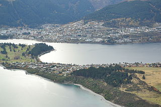
Kelvin Peninsula is a peninsula on the shore of Lake Wakatipu in New Zealand's Otago Region. The peninsula lies between the main body of Lake Wakatipu and the lake's Frankton Arm and its outlet, the Kawarau River. The centre of Queenstown lies on the opposite shore of the Frankton Arm. The peninsula was formerly called Kelvin Heights Peninsula. The name Kelvin Heights is still used for the Queenstown suburb which sits on the peninsula.
Springfield is a suburb of Rotorua in the Bay of Plenty Region of New Zealand's North Island.
Queenstown East is a residential suburb of Queenstown in the South Island of New Zealand. State Highway 6A runs through it.
Queenstown Central is the central business district of Queenstown in the South Island of New Zealand. It also contains residential areas. The area contains Queenstown Primary and St Joseph's schools, and contained Wakatipu High School until it moved to Frankton at the beginning of 2018.
Sunshine Bay is an inlet of Lake Wakatipu and suburb of Queenstown in the South Island of New Zealand. It is located on the lower slopes of the Ben Lomond mountain, west of Fernhill, on the northern side of the lake.

Motukarara is a locality to the northeast of Lake Ellesmere / Te Waihora in the Selwyn District of New Zealand. State Highway 75 passes through the centre of the village, connecting Christchurch with Akaroa and the Banks Peninsula. The Little River Branch, which operated between 1886 and 1962, ran through Motukarara, and is now a shared walkway and cycleway.