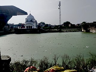
Gangaghat is a city and a municipal board in Unnao district in the state of Uttar Pradesh, India. It's Just 12 km from Unnao, 2 km from Kanpur. It is also known as Shuklaganj and is located on the banks of holy river Ganges about 5 km from Kanpur on the SH 58 to Unnao. The population was 70803 as of the 2001 census. According to the census of 2011 it is 84072. It has 91% of literacy and is 5 km from Kanpur Cantonment. Though it lies in Unnao district, it lies adjacent to Kanpur and hence is a suburb of Kanpur. The city is enlisted as a municipality of Kanpur metropolitan area.

Jhinjhak is a town and a Municipal council in Kanpur Dehat district, India. The town is situated on the Lower Ganges Canal and is approximately 20 kilometres (12 mi) from the industrial city of Dibiyapur.
Rura is a Nagar Panchayat in Kanpur Dehat District in Uttar Pradesh state of the India. The town is situated on the banks of Lower Ganga canal. The district headquarters is 15 km away at Mati. The town is located at a distance of 49 km from famous industrial and educational hub of Kanpur Nagar.
Sirathu is a town and Nagar Panchayat in Kaushambi district in the Indian state of Uttar Pradesh. It is one of oldest town in Kaushambi district. The town has a population of approximately 2700.
Greater Kanpur district is a district in Uttar Pradesh state in northern India. The administrative headquarters of the district are at Mati-Akbarpur. This district is part of Kanpur division. Kanpur was formerly spelled Cawnpore.
Rasulpur Gogumau is a village in Kanpur Dehat district in the Indian state of Uttar Pradesh.
Paman is a village in Kanpur Dehat district in the state of Uttar Pradesh, India.
Tilaunchi is a village in Kanpur Dehat district in the state of Uttar Pradesh, India.
Lalpur is a village in Kanpur Dehat district in the state of Uttar Pradesh, India.
Chaunrah is a village in Kanpur Dehat district in the state of Uttar Pradesh, India.
Ambiyapur is a village in Kanpur Dehat district in the state of Uttar Pradesh, India.
Parjani is a town in Kanpur Dehat district in the state of Uttar Pradesh, India.
Araul is a town in Bilhaur city in Kanpur district in the state of Uttar Pradesh, India on G.T. Road and situated at bank of the holy river Ganga. It is 11 km from Town Bilhaur. Araul is located 62 km distance from its District Main City Kanpur and 15 km distance from Kannauj. It is located 92 km distance from capital of Uttar Pradesh (U.P.) Lucknow. Gangupur is nearest Semi Town (Village)
Mangalpur is a village and a gram panchayat in Kanpur Dehat district in the Indian state of Uttar Pradesh.
Binaur is a town in Kanpur district in the state of Uttar Pradesh, India.

Rawatpur is a suburb in North Kanpur, India, situated about 10 km from Kanpur on the NH 91 to Delhi. The population was 110,000 at the 2001 census. It has 84% of literacy and is 5 km from Kalyanpur. It also Comes under Kanpur metropolitan area.
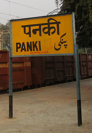
Panki is a suburb of metropolitan Kanpur, India, situated about 12 km from Kanpur Central on the NH 2 to Delhi. The region is home to the Panki Temple, to Panki Thermal Power Station which is among the few thermal energy units in Northern India, and to Panki Logistics Park which is among the largest logistics park of Northern India.
Chaubepur is a suburb in Kanpur, India, situated about 25 km from Kanpur on the Grand Trunk Road to Delhi. It is 7 km from Mandhana, a Kanpur suburb. It comes under Kanpur Metropolitan Area. The population was 4000 at the 2011 census. It has 75% of literacy.
Sachendi is a suburb in Kanpur, India, situated about 10 km from Kanpur on the NH 19 to Delhi. The population was 19,424 as of the 2011 census. It has a 76,20% literacy rate and is 7 km from Panki, a Kanpur suburb. It also comes under Kanpur Metropolitan Area.

Lucknow - Agra Fort Intercity Express is an Intercity Express train of the Indian Railways connecting Agra Fort and Lucknow Junction in Uttar Pradesh. It is currently being operated with 12179/12180 train numbers on a daily basis.


 station platform
 station sign
