Kasganj Junction railway station

Last updated

Kasganj Junction railway station
Indian Railways station
Indian Railways Suburban Railway Logo.svg
Indian Railways logo
General information
LocationState Highway 33, Kasganj, Uttar Pradesh
India
Coordinates 27°48′06″N78°38′43″E / 27.8016°N 78.6453°E / 27.8016; 78.6453
Elevation174 metres (571 ft)
Owned by Indian Railways
Operated by North Eastern Railway
Platforms5
Tracks8
ConnectionsAuto stand
Construction
Structure typeStandard (on-ground station)
ParkingYes
Bicycle facilitiesNo
Other information
StatusSingle electric line
Station codeKSJ
Zone(s) North Eastern Railway
Division(s) Izzatnagar
History
ElectrifiedIn April 2019
Location
India location map.svg
Red pog.svg
Kasganj Junction railway station
Location within India
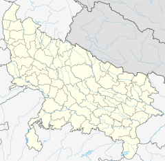
India Uttar Pradesh location map.svg
Red pog.svg
Kasganj Junction railway station
Kasganj Junction railway station (Uttar Pradesh)

The Rohilkhand and Kumaon Railway started construction of railway line from Bhojipura to Kathgodam under a contract dated 12 October 1882. This was the main line, 53.92 miles in length sanctioned in 1882 and opened on 12 October 1884. Later this line was extended from Bareilly to Soron in 1906.

The railway line Kasganj–Soron section was constructed by the Rajputana and Malwa Railways in 1885 when it was constructing the Kanpur–Achnera section. Later on, when the R&KR constructed the Bareilly–Soron line in 1906 the short section Soron–Kasganj was given over to it. The MG extensions from Moradabad to Kashipur, from Kashipur to Ramnagar and Lalkuan to Kashipur were completed by 1908. Kasganj Junction railway station is a main railway station in Kasganj district, Uttar Pradesh. Its code is KSJ. It serves Kasganj city. The station consists of five platforms.[1]

Related Research Articles

<span class="mw-page-title-main">Bareilly</span> City in Uttar Pradesh, India

Bareilly is a city in Bareilly district in the Indian state of Uttar Pradesh. It is among the largest metropolises in Western Uttar Pradesh and is the centre of the Bareilly division as well as the historical region of Rohilkhand. The city lies in the Indo-Gangetic Plains, about 252 kilometres (157 mi) northwest of the state capital, Lucknow, and 265 kilometres (165 mi) east of the national capital, New Delhi. With a population of 903,668 in 2011, it is the eighth most populous city in the state, 17th in northern India and 54th in India. It is located on the bank of Ramganga River and is the site of the Ramganga Barrage built for canal irrigation.

<span class="mw-page-title-main">Bantan Line</span> Railway line in Hyogo prefecture, Japan

The Bantan Line is a railway line that connects Himeji and Wadayama station in Asago City, Hyōgo Prefecture, Japan. The line is operated by the West Japan Railway Company and serves as a connector between the Sanyo Main Line and the Sanin Main Line. The name refers to the ancient provinces of Harima (磨) and Tajima (馬), which the line connects.

<span class="mw-page-title-main">Budaun</span> City in Uttar Pradesh, India

Budaun is a medieval city and headquarters of Budaun district, in the Indian state of Uttar Pradesh. It is located about a mile east of the Sot river, and 27 km north of the Ganges, in the Rohilkhand region of Uttar Pradesh. According to the 2011 census, it has a population of 159,221, which is projected at 161,555 at present. Budaun rose to historical importance as the capital of the Delhi Sultanate for four years from 1210 CE to 1214 CE during the reign of Sultan Iltutmish. It was the most important post of Northern Frontier during Mughal reign. Budaun is a big market, historically famous and religiously important city. Budaun is 230 km south-east of New Delhi and 245 km north-west of Lucknow, both taking about 6 hours by road.

<span class="mw-page-title-main">Etah district</span> District of Uttar Pradesh in India

Etah district is one of the districts of Uttar Pradesh, India, since 1854. Etah City is the district headquarters. Etah district is a part of Aligarh Division.

Ganj Dundawara is a city and a municipal board in Kasganj District and the Aligarh zone in the state Uttar Pradesh, India.

Kasganj is a city, or nagar, and the district headquarters of Kasganj district in the Indian state of Uttar Pradesh. The district was formed by grouping three tehsils on 17 April 2008.

Puranpur is a town and a municipal board in Pilibhit district in the Indian state of Uttar Pradesh. Puranpur is divided into 25 wards for which elections are held every 5 years. After independence and Partition of India the large numbers of Sikhs migrated and settled in the Puranpur Region. Due to dense Sikh population and their lifestyle, The area is also known as Mini Punjab as after Partition of India in 1947. According to Census 2011, primary population is Hindu, followed by Muslims and Christians.

Rithora is a town and a nagar panchayat in Bareilly Tehsil of Bareilly district in the Indian state of Uttar Pradesh.

<span class="mw-page-title-main">Gaini, Uttar Pradesh</span> Village in Uttar Pradesh, India

Gaini is a village in Aonla tehsil, Bareilly district, Uttar Pradesh, India. Gaini is located at 28.21°N 79.16°E. Gaini is 22 kilometer west from the bareilly railway junction.

<span class="mw-page-title-main">Great Northern Railway (Mt Isa line)</span> Narrow gauge railway line in Queensland, Australia

The Great Northern Railway is a 1067 mm gauge railway line in Queensland, Australia. The line stretches nearly 1,000 kilometres linking the port city of Townsville, Australia to the mining town of Mount Isa in north-west Queensland. Along with a passenger service called the Inlander, it is a major freight route connecting the Mount Isa Mines to the Port of Townsville. In 2010, the line moved 5.8 million tonnes of cargo, and this is expected to increase significantly in coming years.

<span class="mw-page-title-main">Bareilly Junction railway station</span> Railway station in Uttar Pradesh, India

Bareilly Junction railway station is a railway station serving Bareilly city in Uttar Pradesh. It is an important station as well as the headquarters of Izzatnagar railway division of the North Eastern Railway zone & Moradabad railway division of the Northern Railway zone. It lies on Lucknow–Moradabad line and Lucknow-Sitapur-Lakhimpur-Pilibhit-Bareilly-Kasganj Line provides a stop for most trains passing through. Bareilly Junction used to serve both broad and metre gauge, Bareilly Junction was connected to Lucknow by both Broad Gauge and Meter Gauge, Broad Gauge was connected to Lucknow via Tilhar, Shahjahanpur, Hardoi. On the other hand Meter Gauge was connected to Lucknow via Pilibhit-Mailani-Lakhimpur-Sitapur, but now the metre gauge is converted into broad gauge.

<span class="mw-page-title-main">Daryaoganj</span> Town in Uttar Pradesh, India

Daryaoganj is a town situated in Kasganj district of Uttar Pradesh state in India. Daryaoganj comes under the Majhola Gram Panchayat, its Vidhan Sabha Region & Block is Patiyali and the Lok Sabha Region is Etah. The Postal Index Number of Daryaoganj is 207244 and comes under Patiyali postal region. The holy river Ganga passes about 12 km away from this town.

<span class="mw-page-title-main">Rohilkund and Kumaon Railway</span> Metre gauge railway in India

Rohilkund and Kumaon Railway (R&KR) was a metre gauge railway in India covering a total network of 592 miles (953 km). It was owned and worked by the Rohilkund and Kumaon Railway Company. The Rohilkund and Kumaon Railway was transferred to the Government of India and merged into the Oudh and Tirhut Railway on 1 January 1943.

Government polytechnic Kasganj, founded in 1983, is a government technical education institute in India. It is affiliated with the Uttar Pradesh Board of Technical Education and approved by the All India Council for Technical Education. It falls under the West zone of UPBTE.

Ramnagar railway station is a small railway station in Nainital district, Uttarakhand. Its code is RMR. It serves Ramnagar city. The station consists of four platforms. The nearest airport is Pantnagar Airport at the distance of 55 km.

<span class="mw-page-title-main">Budaun railway station</span> Railway Station in Uttar Pradesh

Budaun railway station is a main railway station in Badaun district, Uttar Pradesh. Its code is BEM. It serves Budaun city. The station consists of three platforms after gauge conversion of bareilly to kasganj railway line railway station was renovated.

Soron Shukar Kshetra railway station is a small railway station in Kasganj district, Uttar Pradesh. Its code is SRNK. It serves Soron city. The station consists of two platforms. The platforms are not well sheltered. This railway station looks like a religious place. The station is designed like a temple. Two statues of God Varaha are placed at the main gate.

The Kumaun Express is a passenger train belonging to Indian Railways - North Eastern Railway zone that used to run between Agra Fort railway station and Kathgodam railway station in India. It used to run seven days in a week. Its average speed was 36 km/h. Later it used to run in Kasganj Junction railway station and Bareilly City railway station when Bareilly to Lalkuan and Agra Fort to Kasganj was being made Broad Gauge from Metre Gauge railway line.

The Gokul Express was an express train belonging to Indian Railways - North Eastern Railway zone that used to runs between Gonda Junction railway station and Mailani Junction railway station in India. The train last ran on 2016 & was permanently withdrawn due to gauge conversion of Gonda Junction - Nanpara Junction Meter Gauge Line in Broad Gauge Line.

<span class="mw-page-title-main">Alipurduar–Bamanhat branch line</span> Railway route in India

The Alipurduar–Bamanhat branch line is an Indian railway line connecting Alipurduar Junction with Bamanhat. This 72-kilometre (45 mi) track is under the jurisdiction of Northeast Frontier Railway.

References