Jiang Nan subtropical evergreen forests

Last updated
Jiang Nan subtropical evergreen forests
A forest scene of Xibin town,Youxi county.JPG
A forest scene of Xibin town, Youxi County
Ecoregion IM0118.svg
Ecoregion territory (in purple)
Ecology
Realm Indomalayan realm
Biome Tropical and subtropical moist broadleaf forests
Borders
Geography
Area663,555 km2 (256,200 sq mi)
Country China
Provinces
Coordinates 25°15′N113°15′E / 25.250°N 113.250°E / 25.250; 113.250
Conservation
Protected0.5% [1]

The Jiang Nan subtropical evergreen forests ecoregion (WWF ID: IM0118) covers the mountainous divide between the lower Yangtze River and the coastal plain of South China. The region is also a climatic divide between the temperate valleys of the north and the subtropical forests of the south. [2] [3] The region is important for biodiversity and endemic species. The rugged limestone karst hills have been relatively protected from conversion to agriculture, and support specialized plant and animal communities.

Contents

Location and description

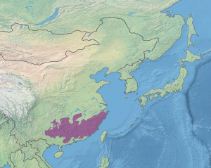
The ecoregion ranges over the Nanling Mountains of Southern China, from the Yunnan–Guizhou Plateau in the west, to the coast of the South China Sea in the east. The mountains separate the lower Yangtze River watershed to the north from the coastal plain to the south. Parts of the mountains sit on granite, but much of the region is limestone, with distinctive pinnacles and karst terrain. Elevations range from 500 meters to 1,500 meters. [2]

Climate

The climate of the ecoregion is Humid subtropical climate, hot wet summer (Köppen climate classification (Cfa)). This climate is characterized by large seasonal temperature differentials. No month averages below 0 °C (32 °F), at least one month averages above 22 °C (72 °F), and four months average over 10 °C (50 °F). Precipitation is generally highest in the summer. [4] [5]

Flora

The forests of the region are subtropical, characterized by evergreen chinquapin ( Castanopsis ), oak ( Quercus ), and Schima (an evergreen member of the tea tree family, Theaceae); Laurels are common in the understory. [2] Elevations over 1,000 meters feature semi-deciduous forests dominated by ring-cupped oak ( Quercus glauca ), Cinnamomum , Chinese elm ( Ulmus parvifolia ), and Bridelia . Bamboo is also an important plant in the regional forests. Most of the lowland forests have been cleared.

Fauna

The area supports a number of vulnerable mammals, including the critically endangered white-headed langur (Trachypithecus poliocephalus leucocephalus), the endangered François' langur (T. francoisi), and the near-threatened mainland serow (Capricornis milneedwardsii). Over 400 species of birds have been recorded in the ecoregion. [2]

Protected areas

0.5% of the ecoregion is in protected areas. Protected areas include Kinmen National Park, Fujian Zhangjiangkou National Mangrove Nature Reserve, and Tian Tai Shan, Qingyuanshan, Tailaoshan, and Gui Ping West Hill scenic areas. [1]

See also

Related Research Articles

<span class="mw-page-title-main">Northeast China Plain deciduous forests</span> Ecoregion in Northeast China

The Northeast China Plain deciduous forests ecoregion covers the flat interior Northeast China Plain and neighboring adjacent northwestern North Korea, in the region historically known as Manchuria. The plain is surrounded by mountains on the north and east, and supports some of China's largest forest tracts. There are also extensive low-lying wetlands, which support important bird populations.

<span class="mw-page-title-main">Changbai Mountains mixed forests</span> Ecoregion in China and North Korea

The Changbai Mountains mixed forests ecoregion covers the Changbai Mountains and surrounding foothills in China and North Korea. The region features extensive and naturally preserved deciduous and conifer forests. The region exhibits high biodiversity due to its relative isolation, temperate climate with high rainfall, and centrality to central Chinese, Siberian, and European floral communities. In 1979, a significant portion of the ecoregion was designated the Changbaishan Biosphere Reserve by UNESCO.

<span class="mw-page-title-main">Changjiang Plain evergreen forests</span> Ecoregion in Central China

The Changjiang Plain evergreen forests ecoregion covers the plain of the Yangtze River (Changjiang) from where it leaves the mountains at the Three Gorges in the west, to the mouth of the Yangtze at the East China Sea. This plain is one of the most densely populated areas on Earth, and most of the original oak and conifer forests have long been converted to agriculture. Extensive wetlands, however, provide habitat for migratory waterfowl and for diverse aquatic species.

<span class="mw-page-title-main">Hainan Island monsoon rain forests</span> Ecoregion in Hainan Island, China

The Hainan Island monsoon rain forests ecoregion covers mountainous interior of Hainan Island in China. The tropical forests receive over 1,000 mm/year of rain, heavily concentrated in the summer rainy season. The island has high levels of biodiversity, with over 4,200 plant species, 630 of which are endemic to the island. The region is under ecological pressure from deforestation for agriculture and timber extraction.

<span class="mw-page-title-main">South China–Vietnam subtropical evergreen forests</span> Ecoregion in South China and Vietnam

The South China-Vietnam subtropical evergreen forests ecoregion covers the mountainous coastal region of southeastern China and northeastern Vietnam. The ecoregional also covers the coastal plain along the South China Sea and Hainan Island. The area has significant biodiversity and ecological importance, with high levels of both endemic and threatened species. Rapid urban expansion is reducing biologically-rich forests and wetlands. Ecologically, the subtropical forests are at the northeastern extent of the Indomalayan realm.

<span class="mw-page-title-main">Qin Ling Mountains deciduous forests</span> Ecoregion in Central China

The Qin Ling Mountains deciduous forests ecoregion covers the Qin Mountains, which run west-to-east across central China. The mountains effectively divide the biological regions of China into north and south. To the north is the Yellow River basin, a loess-soil region of temperate deciduous forests. To the south is the Yangtze River basic, a subtropical forest region. In between, the Qin Mountains support many rare and endemic species, including the Giant panda and the Sichuan snub-nosed monkey.

<span class="mw-page-title-main">South Taiwan monsoon rain forests</span> Ecoregion in Southern Taiwan

The South Taiwan monsoon rain forests ecoregion covers the southern tip of Taiwan, 200 km east of the mainland. The area is one of high biodiversity, due to its location between temperate and subtropical zones, its monsoon exposure, and its high altitude variation.

<span class="mw-page-title-main">Luang Prabang montane rain forests</span> Ecoregion in Central Laos and Northeast Thailand

The Luang Prabang montane rain forests ecoregion covers elevations over 800 meters in the Luang Prabang mountains that straddle the border between northern Thailand and north-central Laos, and the highlands that stretch eastward across north-central Laos. While much of the forest cover has been degraded, there are still large areas of relatively untouched forest.

<span class="mw-page-title-main">Northern Annamites rain forests</span> Ecoregion in the Annamites Range

The Northern Annamites rain forests ecoregion covers the rugged and relatively unexplored northern Annamite Mountains of central Laos and Vietnam. There are high numbers of endemic plant species, and the relative remoteness and isolation of the area supports many rare and endangered animals. Rainfall is somewhat less than the lowland rainforest of the lower elevations in Vietnam, and the temperatures slightly cooler due to the higher elevation.

<span class="mw-page-title-main">Northern Vietnam lowland rain forests</span> Ecoregion in Northern Vietnam

The Northern Vietnam lowland rain forests ecoregion covers the central-eastern coast of Vietnam from the Red River delta in the north to Tam Kỳ in the center of the country and neighboring adjacent parts of Laos. The region is one of the wet evergreen forests, with rain over 50 mm in every month. The forests have been highly degraded by human use, and the high levels of biodiversity have been pushed back into relatively small protected areas like Pu Mat National Park.

<span class="mw-page-title-main">Southern Annamites montane rain forests</span> Ecoregion in the Annamites range

The Southern Annamites montane rain forests ecoregion covers a region of high biodiversity in the central and southern mountains of the Annamite Range in Vietnam. Terrain ranges from wet lowland forest to evergreen hardwood and conifer montane rain forest. There is a short dry season centered on January–February, but fog and dew are common throughout the year and support a lush forest character.

<span class="mw-page-title-main">Northern Khorat Plateau moist deciduous forests</span> Ecoregion in Northern Khorat Plateau

The Northern Khorat Plateau moist deciduous forests ecoregion covers a small area on the border between northeastern Thailand and Laos, in the transition zone between the drier Khorat Plateau to the south and the wetter Annamite Range and Luang Prabang Range mountains to the north. Much of the ecoregion has been converted to agriculture along the floodplain of the middle course of the Mekong River.

<span class="mw-page-title-main">Northern Thailand–Laos moist deciduous forests</span> Ecoregion in Northern Thailand and Laos

The Northern Thailand–Laos moist deciduous forests ecoregion follows the upper course of the Nan River in northern Thailand and the Mekong River in Laos. This area has the highest proportion of tree cover in Thailand, with many forests dominated by Teak. The river valleys have been under pressure from human use: agriculture, teak plantations, and hunting have reduce plant and animal presence.

<span class="mw-page-title-main">Northern Triangle subtropical forests</span>

The Northern Triangle subtropical forests ecoregion covers remote, mountainous terrain in the far north of Myanmar. Due to the regions isolation it is relatively untouched and unexplored by humans. Over 95% of the ecoregion is covered with closed evergreen forest, and importantly for conservation, these forests exist in large contiguous blocks. As of the late 1990s, 140 mammal species were known to be in the region, and new species, such the Leaf muntjac discovered in 1997, are still being found.

<span class="mw-page-title-main">Eastern Java–Bali montane rain forests</span> Ecoregion in Eastern Java and Bali

The Eastern Java–Bali montane rain forests ecoregion covers the higher altitude mountain rainforests on the eastern side of the island of Java, and most of the center of the island of Bali in Indonesia. The region has a number of active volcanoes, but is under pressure from growing human populations pushing into higher elevations and more marginal land. With elevations rising from sea level to 3,426 metres (11,240 ft), and precipitation varying between rainforest and drier forest levels, the area has many different forest types – evergreen, deciduous and semi-alpine.

<span class="mw-page-title-main">Sumatran montane rain forests</span>

The Sumatran montane rain forests ecoregion covers the mountainous elevations of the Barisan Mountains Range that runs the length of the southwestern side of the island of Sumatra in Indonesia. The ecoregion is almost completely surrounded by the lower elevation Sumatran lowland rain forests. The area is one of very high biodiversity - because of the relative isolation, and variety of forest types, there are 7 endemic species of mammals and eight endemic species of birds.

<span class="mw-page-title-main">Mindanao montane rain forests</span> Ecoregion in Mindanao, the Philippines

The Mindanao montane rain forests ecoregion covers the montane forests - the zone between the lowland forest and the treeline - in the mountains on the island of Mindanao in the Philippines. Because the ecoregion covers only elevations above 1,000 metres (3,300 ft), it exists in seven discontinuous patches surrounded by lowland rainforest. Biodiversity is high, both because of the isolation of separate mountain ranges that have led to species variation within the island, and because of the altitude zonation. Because most of the surrounding lowland forest has been cleared for human use, the montane regions have become an important refuge for rare and endemic species.

<span class="mw-page-title-main">Western Java montane rain forests</span> Ecoregion (WWF) in Java, Indonesia

The Western Java montane rain forests ecoregion covers the montane rain forest above 1,000 meters in the volcanic mountain ridges in the west of the island of Java in Indonesia. Several mammals and bird species are found only in this ecoregion, including the Javan mastiff bat (Otomops formosus) and the Volcano mouse (Mus vulcani). Only about one-fifth of the original rainforest remains in its original state, as human pressures are encroaching on the mountain slopes.

<span class="mw-page-title-main">East Afghan montane conifer forests</span> Ecoregion on the Afghanistan-Pakistan border

The East Afghan montane conifer forests ecoregion covers a series of unconnected conifer forests along the border between Afghanistan and Pakistan, at elevations of 2,000 metres (6,600 ft) to 3,400 metres (11,200 ft) above sea level. The ecoregion supports the near-threatened Markhor (Capra falconeri chiltanensis), known as the Screw-horned goat, the national animal of Pakistan. The forests of the ecoregion have been heavily thinned for timber.

<span class="mw-page-title-main">Western Java rain forests</span> Ecoregion in Java, Indonesia

The Western Java rain forests ecoregion covers the lowland rain forests below 1,000 meters in elevation in the western half of the island of Java in Indonesia. There are a variety of forest types - evergreen, semi-evergreen, moist deciduous, and even some patches of freshwater swamp. The forests have degraded by conversion of the low areas to agriculture, and by logging. National parks protect some of the last remaining untouched rain forest. A number of endangered mammals are found in the ecoregion, including the Javan rhinoceros, the silvery gibbon, and the Javan surili.

References

  1. 1 2 Jian Nan subtropical evergreen forests. DOPA Explorer. Retrieved 3 December 2023.
  2. 1 2 3 4 "Jiang Nan subtropical evergreen forests". World Wildlife Fund. Retrieved March 9, 2020.
  3. "Map of Ecoregions 2017". Resolve, using WWF data. Retrieved September 14, 2019.
  4. Kottek, M.; Grieser, J.; Beck, C.; Rudolf, B.; Rubel, F. (2006). "World Map of Koppen-Geiger Climate Classification Updated" (PDF). Gebrüder Borntraeger 2006. Retrieved September 14, 2019.
  5. "Dataset - Koppen climate classifications". World Bank. Retrieved September 14, 2019.