July 1968 England and Wales dust fall storms

Last updated
UK-weather-map-1968-07-01-1800.png
Weather map at 18:00 on 1 July 1968
Type Dust fall thunderstorms
Formed1 July 1968 (1968-07-01)
Duration28 hours[ citation needed ]
Dissipated2 July 1968 (1968-07-02)
Largest hail75 millimetres (3.0 in)
Cardiff
Maximum snowfall or ice accretion450 millimetres (18 in)
Yeadon, West Yorkshire
Maximum rainfall184 millimetres (7.2 in)
Isle of Man
DamageWidespread
Casualties4
Areas affected South West England, Welsh Marches, Northern England

The July 1968 England and Wales dust fall storms were the most severe dust fall storms in the British Isles for over 200 years. [1] A layer of mineral dust blowing north from the Sahara met cold, wet air over the British Isles, resulting in thick, dense clouds and severe thunderstorms across most of England and Wales. These clouds completely blotted out the light in some areas and the rain and hail resulted in property damage and flooding, and at least four people were killed. [2] [3] During the storm, Leeming Bar in North Yorkshire saw 35.7 millimetres (1.41 in) of rain in under 10 minutes – a UK record until 2003. [4]

Rain dust Form of precipitation containing visible dust

Rain dust or snow dust, traditionally known as muddy rain, red rain, or coloured rain, is a variety of rain which contains enough desert dust for the dust to be visible without using a microscope.

Mineral dust

Mineral dust is atmospheric aerosols originated from the suspension of minerals constituting the soil. It is composed of various oxides and carbonates. Human activities lead to 30% of the dust load in the atmosphere. The Sahara Desert is the major source of mineral dust, which subsequently spreads across the Mediterranean and Caribbean seas into northern South America, Central America, and eastern North America, and Europe. Additionally, it plays a significant role in the nutrient inflow to the Amazon rainforest. The Gobi Desert is another source of dust in the atmosphere, which affects eastern Asia and western North America.

Sahara desert in Africa

The Sahara is a desert located on the African continent. It is the largest hot desert in the world, and the third largest desert overall after Antarctica and the Arctic. Its area of 9,200,000 square kilometres (3,600,000 sq mi) is comparable to the area of China or the United States. The name 'Sahara' is derived from a dialectal Arabic word for "desert", ṣaḥra.

Contents

Meteorology

The Hoggar Mountains in Algeria saw a number of severe thunderstorms on 26–27 June. These appear to have blown a large quantity of Sahara dust into the atmosphere, where it was caught in a southerly wind in an atmospheric layer between 10,000 feet (3,000 m) and 17,000 feet (5,200 m) in altitude, forming a classic Spanish plume. Unusually, no clouds formed as this dust blew over continental Europe, and the layer reached England on 30 June largely unrained out. [1]

Hoggar Mountains highland region in Algeria

The Hoggar Mountains are a highland region in the central Sahara, southern Algeria, along the Tropic of Cancer. The mountains cover an area of approximately 550,000 square km.

Spanish plume

The Spanish Plume is a weather pattern in which a plume of warm air moves from the Iberian plateau or the Sahara to northwest Europe giving rise to severe thunderstorms. This meteorological pattern can lead to extreme high temperatures and intense rainfall during the summer months, with potential for flash flooding, damaging hail storms, and tornado formation. Some of these intense thunderstorms are formed from thermal lows. Thermal lows are also known as heat lows. Thermal lows can be semipermanent features around some parts of Europe, particularly in the summer season. These thermal lows can be developed or created around Spain, Portugal, France etc., during the summer season because of the intense heat. Thermal low pressure can be located around the world, particularly in the summer or in tropical regions.

The warm desert air brought a heatwave over Southern England, with temperatures in London on 1 July measured at 32 °C (90 °F), until it met the much cooler, moister Atlantic airstream. The boundary between the two formed a squall line stretching from Devon, along the England–Wales border and up across Northern England to the River Tees. [1] Thick clouds, darkened by the Sahara dust, rose to 44,000 feet (13,000 m), plunging areas along the squall line into total darkness. In some areas, the lightning continued for 24 hours, and ball lightning was seen at RAF Chivenor in Devon. [5]

Squall line a line of thunderstorms

A squall line or quasi-linear convective system (QLCS) is a line of thunderstorms forming along or ahead of a cold front. In the early 20th century, the term was used as a synonym for cold front. It contains heavy precipitation, hail, frequent lightning, strong straight-line winds, and possibly tornadoes and waterspouts. Strong straight-line winds can occur where the squall line is in the shape of a bow echo. Tornadoes can occur along waves within a line echo wave pattern (LEWP), where mesoscale low-pressure areas are present. Some bow echoes which develop within the summer season are known as derechos, and they move quite fast through large sections of territory. On the back edge of the rainband associated with mature squall lines, a wake low can be present, sometimes associated with a heat burst.

The England–Wales border, sometimes referred to as the Wales–England border or the Anglo-Welsh border, is the border between England and Wales, two constituent countries of the United Kingdom. It runs for 160 miles (260 km) from the Dee estuary, in the north, to the Severn estuary in the south. It has followed broadly the same line since the 8th century, and in part that of Offa's Dyke; the modern boundary was fixed in 1536, when the former marcher lordships which occupied the border area were abolished and new county boundaries were created.

Northern England Place in England

Northern England, also known as the North of England or simply the North, is the northern part of England, considered as a single cultural area. It extends from the Scottish border in the north to near the River Trent in the south, although precise definitions of its southern extent vary. Northern England approximately comprises three statistical regions: the North East, North West and Yorkshire and the Humber. These have a combined population of around 14.9 million as of the 2011 Census and an area of 37,331 km2. Northern England contains much of England's national parkland but also has large areas of urbanisation, including the conurbations of Greater Manchester, Merseyside, Teesside, Tyneside, Wearside, and South and West Yorkshire.

The dust particles served as seeds for nucleation, causing water to rapidly precipitate out and form especially large raindrops and hailstones. [6] The thunderstorms resulted in one of the most widespread intense hail falls ever recorded in the UK, with hail events in 9 separate places reported as "severe" (H3) or greater on the TORRO hail scale, and the strongest rated "destructive" (H6). [7] Hailstones 75 millimetres (3.0 in) across – the size of a tennis ball – were measured at Cardiff Airport, and the local newspaper for Hartland, Devon, reported the finding of "a piece of ice 4 inches (100 mm) long". [5] [8]

Nucleation step of self-assembly, including crystallization

Nucleation is the first step in the formation of either a new thermodynamic phase or a new structure via self-assembly or self-organization. Nucleation is typically defined to be the process that determines how long an observer has to wait before the new phase or self-organized structure appears. For example, if a volume of water is cooled below 0° C, it will tend to freeze into ice. Volumes of water cooled only a few degrees below 0° C often stay completely free of ice for long periods. At these conditions, nucleation of ice is either slow or does not occur at all. However, at lower temperatures ice crystals appear after little or no delay. At these conditions ice nucleation is fast. Nucleation is commonly how first-order phase transitions start, and then it is the start of the process of forming a new thermodynamic phase. By contrast, new phases at continuous phase transitions start to form immediately.

The Tornado and Storm Research Organisation (TORRO) was founded by Terence Meaden in 1974. Originally called the Tornado Research Organisation it was expanded in 1982 following the inclusion of the Thunderstorm Census Organisation (TCO) after the death of its founder Morris Bower and his wife. The current Head of TORRO is Paul Knightley, a professional meteorologist.

Tennis ball ball used in the sport of tennis

A tennis ball is a ball designed for the sport of tennis. Tennis balls are fluorescent yellow at major sporting events, but in recreational play can be virtually any color. Tennis balls are covered in a fibrous felt which modifies their aerodynamic properties, and each has a white curvilinear oval covering it.

Along with the hail came heavy rain, with the 9 minute 35.7 millimetres (1.41 in) fall at Leeming Bar setting a record for a sub-10-minute total. The Isle of Man measured 184 millimetres (7.2 in) of rain over the 48 hour time period associated with the storms. Areas south and east of the squall line saw less severe storms, but the rain that fell in the night of 1–2 July 1968 was rich in Saharan dust, turning it blood red and leaving dusty deposits on the surfaces it fell on – only the south coast and uplands of Wales avoided the red rain. [1] The last comparable storm associated with Saharan dust was seen in October 1755. [1]

Leeming Bar village in United Kingdom

Leeming Bar is a village in the civil parish of Aiskew and Leeming Bar, in the Hambleton district of North Yorkshire, England. The village lay on the original Great North Road before being bypassed. It is now home to a large industrial estate and the main operating site of the Wensleydale Railway.

Isle of Man British Crown dependency

The Isle of Man, often referred to simply as Mann, is a self-governing British Crown dependency in the Irish Sea between Great Britain and Ireland. The head of state is Queen Elizabeth II, who holds the title of Lord of Mann and is represented by a lieutenant governor. Defence is the responsibility of the United Kingdom.

Aftermath

The storms resulted in at least four fatalities. Three people were struck by lightning – a 72-year-old woman in Northallerton, a 14-year-old girl in Oldham, and an unnamed woman in Hampsthwaite – while an 80-year-old man drowned in flooding in Welshpool. [2] [3] [9] Hail broke windows and dented cars across a wide swathe of the country, and damage was reported at both Cardiff Airport and RAF Chivenor. At Yeadon, West Yorkshire, the accumulated hail piled 450 millimetres (18 in) deep, and in parts of Yorkshire the ice was so severe that roads had to be cleared with bulldozers. [5]

Northallerton town in the Hambleton district of North Yorkshire, England

Northallerton is a market town and civil parish in the Hambleton district of North Yorkshire, England. It lies in the Vale of Mowbray and at the northern end of the Vale of York. It had a population of 15,741 according to the 2001 census, which had risen to 16,832 in 2011. It has served as the county town of the North Riding of Yorkshire and since 1974, of North Yorkshire. Northallerton is made up of four wards, North, Broomfield, Romanby and Central.

Oldham town in Greater Manchester, England

Oldham is a town in Greater Manchester, England, amid the Pennines and between the rivers Irk and Medlock, 5.3 miles (8.5 km) southeast of Rochdale and 6.9 miles (11.1 km) northeast of Manchester. It is the administrative centre of the Metropolitan Borough of Oldham, which had a population of 230,800 in 2015.

Hampsthwaite village in United Kingdom

Hampsthwaite is a large village and civil parish in Nidderdale in the Harrogate district of North Yorkshire, England. It lies on the south bank of the River Nidd 5 miles (8 km) north west of Harrogate. In the 2011 census the parish had a population of 1,083.

Bradford saw severe flooding on 2 July, with many streets in the centre left underwater, as did the Isle of Man. [10] [11] The Met Office noted that many rivers across the West Country and the Midlands burst their banks, and said that every town and village in Devon was flooded, with damage to property and crops assessed as "a major disaster". [12] The summer of 1968 would prove to be one of the worst ever recorded for flooding in the UK, with further storms causing the Chew Stoke flood of 1968 just a week later and the Great Flood of 1968 that September, and would not be equalled until the 2007 floods. [13]

In the wake of the storm, a number of normally rare African and Southern European insects were reported across England, having been blown across with the Sahara dust. [14]

See also

Related Research Articles

Hail Form of solid precipitation

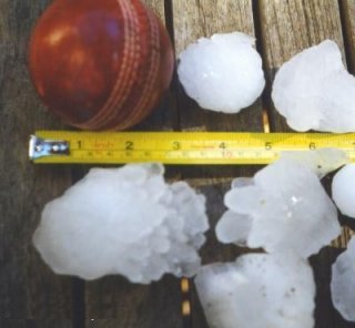
Hail is a form of solid precipitation. It is distinct from ice pellets, though the two are often confused. It consists of balls or irregular lumps of ice, each of which is called a hailstone. Ice pellets fall generally in cold weather while hail growth is greatly inhibited during cold surface temperatures.

Thunderstorm type of weather

A thunderstorm, also known as an electrical storm or a lightning storm, is a storm characterized by the presence of lightning and its acoustic effect on the Earth's atmosphere, known as thunder. Relatively weak thunderstorms are sometimes called thundershowers. Thunderstorms occur in a type of cloud known as a cumulonimbus. They are usually accompanied by strong winds, and often produce heavy rain and sometimes snow, sleet, or hail, but some thunderstorms produce little precipitation or no precipitation at all. Thunderstorms may line up in a series or become a rainband, known as a squall line. Strong or severe thunderstorms include some of the most dangerous weather phenomena, including large hail, strong winds, and tornadoes. Some of the most persistent severe thunderstorms, known as supercells, rotate as do cyclones. While most thunderstorms move with the mean wind flow through the layer of the troposphere that they occupy, vertical wind shear sometimes causes a deviation in their course at a right angle to the wind shear direction.

Storm any disturbed state of an astronomical bodys atmosphere

A storm is any disturbed state of an environment or in an astronomical body's atmosphere especially affecting its surface, and strongly implying severe weather. It may be marked by significant disruptions to normal conditions such as strong wind, tornadoes, hail, thunder and lightning, heavy precipitation, heavy freezing rain, strong winds, or wind transporting some substance through the atmosphere as in a dust storm, blizzard, sandstorm, etc.

Supercell thunderstorm that is characterized by the presence of a mesocyclone

A supercell is a thunderstorm characterized by the presence of a mesocyclone: a deep, persistently rotating updraft. For this reason, these storms are sometimes referred to as rotating thunderstorms. Of the four classifications of thunderstorms, supercells are the overall least common and have the potential to be the most severe. Supercells are often isolated from other thunderstorms, and can dominate the local weather up to 32 kilometres (20 mi) away. They tend to last 2-4 hours.

Severe storms in Australia

Severe storms in Australia. refers to the storms, including cyclones, which have caused severe damage in Australia.

Severe weather

Severe weather refers to any dangerous meteorological phenomena with the potential to cause damage, serious social disruption, or loss of human life. Types of severe weather phenomena vary, depending on the latitude, altitude, topography, and atmospheric conditions. High winds, hail, excessive precipitation, and wildfires are forms and effects of severe weather, as are thunderstorms, downbursts, tornadoes, waterspouts, tropical cyclones, and extratropical cyclones. Regional and seasonal severe weather phenomena include blizzards (snowstorms), ice storms, and duststorms.

Atmospheric convection

Atmospheric convection is the result of a parcel-environment instability, or temperature difference layer in the atmosphere. Different lapse rates within dry and moist air masses lead to instability. Mixing of air during the day which expands the height of the planetary boundary layer leads to increased winds, cumulus cloud development, and decreased surface dew points. Moist convection leads to thunderstorm development, which is often responsible for severe weather throughout the world. Special threats from thunderstorms include hail, downbursts, and tornadoes.

Climate of the British Isles

The British Isles are an archipelago off the northwest coast of Europe, consisting of the islands of Great Britain and Ireland along with smaller surrounding ones. Its position allows dry continental air from Eurasia to meet wetter air from the Atlantic Ocean, which causes the weather to be highly variable, often changing many times during the day. It is defined as a temperate oceanic climate, or Cfb on the Köppen climate classification system. It is significantly warmer than other regions on the same latitude, due to the warmth provided by the Gulf Stream. Temperatures do not often switch between great extremes, with warm summers and mild winters.

1999 Sydney hailstorm 1999 storm in Australia

The 1999 Sydney hailstorm was the costliest natural disaster in Australian insurance history, causing extensive damage along the east coast of New South Wales. The storm developed south of Sydney on the afternoon of Wednesday, 14 April 1999 and struck the city's eastern suburbs, including the central business district, later that evening.

1947 Sydney hailstorm

The 1947 Sydney hailstorm was a natural disaster which struck Sydney, Australia, on 1 January 1947. The storm cell developed on the morning of New Year's Day, a public holiday in Australia, over the Blue Mountains, hitting the city and dissipating east of Bondi in the mid-afternoon. At the time, it was the most severe storm to strike the city since recorded observations began in 1792.

2010 Victorian storms

The 2010 Victorian storms were a series of storms that passed through much of the Australian state of Victoria on 6 March and 7 March 2010. One of the most severe storms passed directly over Greater Melbourne, bringing lightning, flash flooding, very large hail and strong winds to the state's capital.

The climate of Islamabad is a humid subtropical climate (Köppen climate classification, with five seasons: Winter, Spring, Summer, Rainy Monsoon and Autumn. The hottest month is June, where average highs routinely exceed 38 °C. The wettest month is July, with heavy rainfall and evening thunderstorms with the possibility of cloudburst. The coolest month is January, with temperatures variable by location. In Islamabad, temperatures vary from cold to mild, routinely dropping below zero. In the hills there is sparse snowfall. The weather ranges from a minimum of −3.9 °C in January to a maximum of 46.1 °C in June. The average low is 2 °C in January, while the average high is 38.1 °C in June. The highest temperature recorded was 46.5 °C in June, while the lowest temperature was −4 °C in January. On 23 July 2001, Islamabad received a record breaking 620 millimetres of rain fell in just 10 hours. It was the heaviest rainfall in 24 hours in Islamabad and at any locality in Pakistan during the past 100 years. Following is the weather observed over Islamabad Airport, which is actually located in Rawalpindi.

Montreal flood of 1987

The Montreal flood of 1987 happened on July 14 of that year when a series of strong thunderstorms crossed the island of Montreal, Canada, between the noon hour and 2:30 p.m. Over 100 millimetres (3.9 in) of rain fell during this very short period of time. The sewer systems were overwhelmed by the deluge and the city was paralyzed by the flooded roads. Autoroute 15, a sunken highway also known as the Decarie Expressway, soon filled with water, trapping motorists. Some 350,000 houses lost electricity, and tens of thousands had flooded basements. Two people died, one in a submerged car and another who was electrocuted.

Hailstorm Alley is a colloquial term referring to an area of south and central Alberta, Canada where hail storms are frequently produced. These storms frequently produce hail that is damaging to property. This area stretches from High River in southern Alberta, northward through Calgary, through Red Deer to Lacombe and then westward to Rocky Mountain House. It is known to be one of the worst areas in the world for damaging hail produced by thunderstorms. These are regarded as loose boundaries. While this area is common for damaging hailstorms, the reality is damaging hailstorms occur over much of central and southern Alberta every summer. The City of Calgary is regarded as the hailstorm capital of Canada.

The 1808 United Kingdom heat wave was a period of exceptionally high temperatures during July 1808. In the Central England Temperature series, dating back to 1659, at the time it was the 2nd hottest July on record, the hottest since 1783. The month included some of the highest temperatures ever recorded in the UK.

References

  1. 1 2 3 4 5 Stevenson, Catherine M. (1969). "The dust fall and severe storms of 1 July 1968". Weather. 66 (5): 125–127. doi:10.1002/wea.780.
  2. 1 2 "Two women and girl killed in freak storms". The Guardian. 3 July 1968.
  3. 1 2 "Multi-coloured rain on the hottest day". Birmingham Daily Post. 2 July 1968.
  4. Harley, Trevor. "1968". British Weather. Retrieved 2 October 2018.
  5. 1 2 3 Webb, Jonathan D.C.; Elsom, Derek M. (2016). "Severe Hailstorms in the United Kingdom and Ireland: A Climatological Survey with Recent and Historical Case Studies". Extreme Weather: Forty Years of the Tornado and Storm Research Organisation (TORRO). pp. 181–185. Retrieved 2 October 2018.
  6. Darwent, Thelma J. Flood studies conference: papers and discussion on the Flood studies report and discussion on Reservoir flood standards : proceedings of the Conference. Institution of Civil Engineers. p. 13.
  7. "The 52 Most Intense Hailstorms, 1650 To Date". TORRO. Retrieved 2 October 2018.
  8. Brockway, Derek (14 December 2011). "How hailstones are formed". BBC Weather. Retrieved 2 October 2018.
  9. "Teesside remembers the Great Darkness of 1968". Teesside Gazette. 2 July 2008. Retrieved 2 October 2018.
  10. Barnett, David (3 July 2009). "Memories flood back". Telegraph and Argus . Retrieved 2 October 2018.
  11. Ayres, Odele (8 May 2018). "21 pictures of Bradford city centre underwater in 1968". Telegraph and Argus . Retrieved 2 October 2018.
  12. "Monthly Weather Report – July 1968" (PDF). Met Office. Retrieved 2 October 2018.
  13. Webb, Jonathan D.C.; Pike, William S. (July 2010). "Extreme thundery rainfall event in central and southern England, 19-20 July 2007: Part two: Comparisons to previous severe summer rainfall events" (PDF). International Journal of Meteorology. 35 (351). Retrieved 2 October 2018.
  14. French, R. A. (1969). "Moth immigrations in the British Isles in July 1968". Entomologist's Gazette. 20: 37.