Bristol Channel floods, 1607

Last updated

Contemporary depiction of the 1607 flood. The church is thought to be St Mary's at Nash, near Newport. Somerset.gif
Contemporary depiction of the 1607 flood. The church is thought to be St Mary's at Nash, near Newport.

The Bristol Channel floods, 30 January 1607, [lower-alpha 1] drowned many people and destroyed a large amount of farmland and livestock. The known tide heights, probable weather, extent and depth of flooding, and coastal flooding elsewhere in the UK on the same day all point to the cause being a storm surge.

Contents

Description

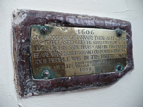
Flood plaque, in St Mary's Church, Goldcliff, near Newport. 754586 a96910f6.jpg
Flood plaque, in St Mary's Church, Goldcliff, near Newport.

On 30 January 1607, around noon, the coasts of the Bristol Channel suffered from unexpectedly high floodings that broke the coastal defences in several places. Low-lying places in Devon, Somerset, Gloucestershire, and South Wales were flooded. The devastation was particularly severe on the Welsh side, extending from Laugharne in Carmarthenshire to above Chepstow in Monmouthshire. Cardiff was the most badly affected town, with the foundations of St Mary's Church destroyed. [1]

It is estimated that 2,000 or more people were drowned, houses and villages were swept away, an estimated 200 square miles (51,800 ha) of farmland inundated, and livestock destroyed, [2] wrecking the local economy along the coasts of the Bristol Channel and Severn Estuary.

The coast of Devon and the Somerset Levels as far inland as Glastonbury Tor, 14 miles (23 km) from the coast, were also affected. The sea wall at Burnham-on-Sea gave way, [3] and the water flowed over the low-lying levels and moors.

Thirty villages in Somerset were affected, including Brean which was "swallowed up" and where seven out of the nine houses were destroyed with 26 of the inhabitants dying. For ten days the Church of All Saints at Kingston Seymour, near Weston-super-Mare, was filled with water to a depth of 5 feet (1.5 m). A chiselled mark remains showing that the maximum height of the water was 7.74 metres (25 feet 5 inches) above sea level. [4] [5]

A number of commemorative plaques still remain, up to 8 feet (2.4 m) above sea level, showing how high the waters rose on the sides of surviving churches. For example, at Goldcliff near Newport the church has a small brass plaque, inside on the north wall near the altar, today about three feet above ground level, marking the height of the flood waters. The plaque records the year as 1606 because, under the Julian calendar in use at that time, the new year did not start until Lady Day, 25 March. The resultant financial loss in the parish was estimated as £5,000.

The flood was commemorated in a contemporary pamphlet entitled God's warning to the people of England by the great overflowing of the waters or floods. [6] [7]

Contemporary accounts of the flood were written by people such as the Puritan pamphleteer, William Jones:

as soone as the people of those Countries, perceived that it was the violence of the Waters of the raging Seas, and that they began to exceede the compasse of their accustomed boundes, and making so furiously towardes them. happy were they that could make the best, and most speed away, many of them, leaving all their goods and substance, to the merciles Waters, being glad to escape away with life themselues: But so violent and swift were the outragiouse waves, that pursued one an other, with such vehemencie, and the Waters multiplying so much in so short a time, that in lesse then five houres space most part of those cuntreys (and especially the places which lay lowe) were all over flowen, and many hundreds of people both men women, and children were then quite devoured, by these outragious waters, such was the furie of the waves, of the Seas, the one of them dryving the other forwardes with such force and swiftnes, that it is almost incredible for any to beleeve the same....Many there were which fled into the tops of high trees, and there were inforced to abide some three daies, some more, and some lesse, without any victuals at all, there suffring much colde besides many other calamities, and...through ever much hunger and cold, some of them fell down againe out of the Trees, and so were like to perish for want of succour. Othersame, sate in the tops of high Trees as aforesaid, beholding their wives, children, and servants, swimming (remediles of all succour) in the Waters. Other some sitting in the tops of Trees might behold their houses overflowne with the waters. some their houses caryed quite away: and no signe or token left there of them. [8] .

"Gods warning to his people of England By the great over-flowing of the waters..." by William Jones, 1607

Cause

There are similarities to descriptions of the 1953 floods in East Anglia which were caused by a storm surge. Horsburgh and Horritt have shown that the tide and probable weather at the time were capable of generating a surge that is consistent with the observed inundation. They point to an exceptionally high spring tide in the Bristol Channel on 30 January 1607 of 7.86m, a severe south-westerly gale with peak winds measured at Barnstaple from 3am to noon, and coastal flooding in East Anglia at night on the 30th consistent with a storm tracking eastward. [9]

Tsunami hypothesis

A 2002 research paper, following investigations by Professor Simon Haslett of Bath Spa University and Australian geologist Ted Bryant of the University of Wollongong, suggested that the flooding may have been caused by a tsunami, after the authors had read some eyewitness accounts in the historical reports which described the flood. [10] [11] [12] The British Geological Survey has suggested that, as there is no evidence of a landslide off the continental shelf, a tsunami would most likely have been caused by an earthquake on a known unstable fault off the coast of southwest Ireland, causing the vertical displacement of the sea floor. [13] One contemporary report describes an earth tremor on the morning of the flood; [14] however, other sources date this earthquake to a few months after the event. [15]

Haslett and Bryant's evidence for the tsunami hypothesis included massive boulders that had been displaced up the beach by enormous force; a layer up to 8 inches (20 cm) thick composed of sand, shells and stones within an otherwise constant deposit of mud that was found in boreholes from Devon to Gloucestershire and the Gower Peninsula; and rock erosion characteristic of high water velocities throughout the Severn Estuary. [16] [17]

However in attributing the flood to a storm surge, Horsburgh and Horritt show that those proposing a tsunami hypothesis underestimate the volume of water and coastal damage involved in storm surges, and failed to account both for flooding on the opposite side of the country on the same day. There is also a lack of evidence for the event impacting western Wales, Cornwall or southern Ireland. Their tsunami modelling showed that it would not be possible for a tsunami not to affect these areas and cause flooding elsewhere in the country. Contemporary sources also indicate the flooding proceeded for a period of five hours, which is consistent with a storm surge rather than a tsunami.

Future recurrence

While the risk of similar events in the foreseeable future is considered to be low, it is estimated that the potential cost caused by comparable flooding to residential, commercial, industrial, and agricultural property could range from £7 to £13 billion at 2007 insured values. [18] There has also been concern that the nuclear power stations at Hinkley Point and Oldbury could be endangered. [19]

On the 400th anniversary, 30 January 2007, BBC Somerset looked at the possible causes and asked whether it could happen again in the county. [20]

See also

Notes

  1. 1 2 Modern sources for this event commonly use the Gregorian calendar, however contemporary records record the event as happening on 20 January 1606/07 under the Julian calendar (see for example the flood plaque, in St Mary's Church pictured on this page where the date is given as 20 January 1606). For a more detailed explanation of these changes in calendar and dating styles, see Old Style and New Style dates.

Related Research Articles

River Severn River in the United Kingdom

The River Severn is the longest river in Great Britain at a length of 220 miles (354 km). With an average discharge of 107 m3/s (3,800 cu ft/s) at Apperley, Gloucestershire, it has by far the greatest water flow in England and Wales.

Bristol Channel major inlet in the island of Great Britain

The Bristol Channel is a major inlet in the island of Great Britain, separating South Wales from Devon and Somerset in South West England. It extends from the lower estuary of the River Severn to the North Atlantic Ocean. It takes its name from the English city of Bristol, and is over 30 miles (50 km) wide at its western limit.

A storm surge, storm flood, tidal surge or storm tide is a coastal flood or tsunami-like phenomenon of rising water commonly associated with low pressure weather systems. Its severity is affected by the shallowness and orientation of the water body relative to storm path, as well as the timing of tides. Most casualties during tropical cyclones occur as the result of storm surges. It is a measure of the rise of water beyond what would be expected by the normal movement related to tides.

North Sea flood of 1953 Late January-early February 1953 North sea flood storm

The 1953 North Sea flood was a major flood caused by a heavy storm that occurred on the night of Saturday, 31 January 1953 and morning of Sunday, 1 February 1953. The floods struck the Netherlands, Belgium, England and Scotland.

Severn Estuary the estuary of the River Severn, the longest river in Great Britain; mouth of the Severn, Wye, Usk, and the Bristol Avon

The Severn Estuary is the estuary of the River Severn, the longest river in Great Britain. It is the confluence of four major rivers, being the Severn, Wye, Usk and Avon, and other smaller rivers. Its high tidal range, approximately 50 feet (15 m), means that it has been at the centre of discussions in the UK regarding renewable energy.
Arlingham village in the United Kingdom

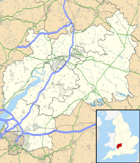
Arlingham is a village and civil parish in the Stroud District of Gloucestershire, England. The 2001 Census recorded a parish population of 410, increasing to 459 at the 2011 census. The parish contains the hamlets of Milton End, Overton and Priding The next parish to the east is Fretherne with Saul.

Geology of Somerset

Somerset is a rural county in the southwest of England, covering 4,171 square kilometres (1,610 sq mi). It is bounded on the north-west by the Bristol Channel, on the north by Bristol and Gloucestershire, on the north-east by Wiltshire, on the south-east by Dorset, and on the south west and west by Devon. It has broad central plains with several ranges of low hills. The landscape divides into four main geological sections from the Silurian through the Devonian and Carboniferous to the Permian which influence the landscape, together with water-related features.

Severn Barrage range of ideas for building a barrage from the English coast to the Welsh coast over the Severn tidal estuary

The Severn Barrage is any of a range of ideas for building a barrage from the English coast to the Welsh coast over the Severn tidal estuary. Ideas for damming or barraging the Severn estuary have existed since the 19th century. The building of such a barrage would constitute an engineering project comparable with some of the world's biggest. The purposes of such a project has typically been one, or several of: transport links, flood protection, harbour creation, or tidal power generation. In recent decades it is the latter that has grown to be the primary focus for barrage ideas, and the others are now seen as useful side-effects. Following the Severn Tidal Power Feasibility Study (2008–10), the British government concluded that there was no strategic case for building a barrage but to continue to investigate emerging technologies. In June 2013 the Energy and Climate Change Select Committee published its findings after an eight-month study of the arguments for and against the Barrage. MPs said the case for the barrage was unproven. They were not convinced the economic case was strong enough and said the developer, Hafren Power, had failed to answer serious environmental and economic concerns.

Caldicot and Wentloog Levels

The Caldicot and Wentloog Levels are two areas of low-lying estuarine alluvial wetland and intertidal mudflats adjoining the north bank of the Severn Estuary, either side of the River Usk estuary near Newport in south east Wales. They are also known collectively as the Monmouthshire Levels or Gwent Levels, and the name Wentloog is sometimes spelled Wentlooge in official publications.

Tsunamis affecting the British Isles are extremely uncommon, and there have only been two confirmed cases in recorded history. Meteotsunamis are somewhat more common, especially on the southern coasts of England around the English and Bristol Channels.

Church of All Saints, Kingston Seymour church in North Somerset, UK

The Church of All Saints in Kingston Seymour, Somerset, England dates from the late 14th or early 15th century. It has been designated as a Grade I listed building.

Climate of south-west England

The climate of south-west England is classed as oceanic (Cfb) according to the Köppen climate classification. The oceanic climate is typified by cool winters with warmer summers and precipitation all year round, with more experienced in winter. Annual rainfall is about 1,000 millimetres (39 in) and up to 2,000 millimetres (79 in) on higher ground. Summer maxima averages range from 18 °C (64 °F) to 22 °C (72 °F) and winter minima averages range from 1 °C (34 °F) to 4 °C (39 °F) across the south-west. It is the second windiest area of the United Kingdom, the majority of winds coming from the south-west and north-east. Government organisations predict the area will experience a rise in temperature and become the hottest region in the United Kingdom.

Burnham-on-Sea Low Lighthouse lighthouse in Burnham-on-Sea and Highbridge, Sedgemoor, Somerset, England

The Low Lighthouse is one of three lighthouses in Burnham-on-Sea, Somerset, England and the only one which is still active. It is a Grade II listed building.

The December 1981 windstorm was a severe storm that particularly affected southern England, Wales and south west France during December 13, 1981. The storm formed as a secondary low.

Coastal flooding occurs when normally dry, low-lying land is flooded by seawater. The extent of coastal flooding is a function of the elevation inland flood waters penetrate which is controlled by the topography of the coastal land exposed to flooding. The seawater can flood the land via from several different paths:

Cyclone Xaver A winter storm that affected northern Europe in 2013

Cyclone Xaver also known as the North Sea flood or tidal surge of 2013, was a winter storm that affected northern Europe. Force 12 winds and heavy snowfall were predicted along the storm's path, and there were warnings of a significant risk of storm surge leading to coastal flooding along the coasts of the North and Irish Seas.

Cyclones Anne and Christina were a pair of winter storms that affected western Europe several days apart in early January 2014. The storms brought storm surges along the coasts of France, Ireland and the United Kingdom on high spring tides a month after Cyclone Xaver brought surges during the previous peak tides to northern Europe.

2013–14 United Kingdom winter floods series of 2013-2014 winter storms in the UK

The 2013–2014 United Kingdom winter floods saw areas of Ireland and the United Kingdom inundated following severe storms. The south of England saw heavy rainfalls associated with these storms which caused widespread flooding, power cuts and major disruptions to transport. Economically, the worst affected areas were Somerset, Devon, Dorset and Cornwall in the south west and the Thames Valley in the south east. The Met Office reported the storms were responsible for the wettest December to January period since 1876. The flood phenomena ranged from coastal flooding, pluvial flooding, fluvial flooding to groundwater flooding. The flooding resulted in the inundation of the majority of the Somerset Levels and saw the main railway line to Cornwall and West Devon at Dawlish severed for several weeks.

The Plymouth Coastal Observatory (PCO) is the data management centre for the South West Regional Coastal Monitoring Programme. It is managed and led by Teignbridge District Council in partnership with other south west of England local authorities and the Environment Agency.

References

  1. Disney, Michael (4 January 2005). "Britain had its own big waves - 400 years ago" . The Times . London. Retrieved 20 February 2008.
  2. BBC staff (24 September 2014). "The great flood of 1607: could it happen again?". BBC Somerset. Retrieved 20 February 2008.
  3. "Burnham on Sea". Somerset Guide. Archived from the original on 1 January 2011. Retrieved 10 May 2010.
  4. Hawkins, Desmond (1982). Avalon and Sedgemoor. pp. 29–30. ISBN   0-86299-016-5.
  5. 1607 Bristol Channel Floods: 400-Year Retrospective RMS Special Report (PDF). Risk Management Solutions (RMS). 2007. p. 12.
  6. Disney 2005
  7. "Gods Warning to his people of England". The British Library. Retrieved 20 February 2008.
  8. William Jones of Usk (1607). "Gods warning to his people of England By the great over-flowing of the waters or floudes lately hapned in South-wales and many other places. Wherein is described the great losses, and wonderfull damages, that hapned thereby: by the drowning of many townes and villages, to the utter undooing of many thousandes of people". Printed by R. Blower for W. Barley, and Io. Bayly, and are to besolde in Gratious street.
  9. Horsburgh, K. J.; Horritt, M. (2006). "The Bristol Channel floods of 1607 – reconstruction and analysis". Weather. 61 (10): 272–277. doi:10.1256/wea.133.05.
  10. BBC staff (4 April 2005). "Tsunami theory of flood disaster". BBC News Online . Retrieved 13 November 2010.
  11. Bryant, Edward; Haslett, Simon (2007). "Catastrophic Wave Erosion, Bristol Channel, United Kingdom: Impact of Tsunami?". Journal of Geology. 115 (3): 253–270. Bibcode:2007JG....115..253B. doi:10.1086/512750.
  12. Bryant, Edward; Haslett, Simon (2002). "Was the AD 1607 Coastal Flooding Event in the Severn Estuary and Bristol Channel (UK) Due to a Tsunami". Archaeology in the Severn Estuary (13): 163–167. ISSN   1354-7089.
  13. BBC staff 2005
  14. Haslett, Simon K. (2010). Somerset Landscapes: Geology and landforms. Usk: Blackbarn Books. p. 159. ISBN   9781456416317.
  15. Zijlstra, Albert (16 June 2016). "The Bristol Tsunami". Volcanocafe. Retrieved 10 April 2018.
  16. Bryant & Haslett 2007 , pp. 253–270
  17. Haslett, Simon; Bryant, Edward (2004). "The AD 1607 Coastal Flood in the Bristol Channel and Severn Estuary: Historical Records from Devon and Cornwall (UK)". Archaeology in the Severn Estuary (15): 81–89. ISSN   1354-7089.
  18. RMS 2007 , p. 16
  19. RMS 2007 , p. 17
  20. BBC staff 2014

Published sources