2008 Morpeth floods

Last updated

2008 Morpeth floods
Telford Bridge 6 September 2008.jpg
St George's Church and Telford Bridge
at 1332 BST on 6 September 2008.
Date6 September 2008
Location Morpeth, Northumberland, England
Deathsnone
Property damageapprox. £40 million

The 2008 Morpeth floods occurred on Saturday 6 September 2008 in Morpeth, a town in Northumberland, northeastern England, when, following sustained heavy rainfall during the previous twenty-four hours, the River Wansbeck burst its banks and overwhelmed the town's flood defences. Nearly one thousand properties, mostly residential, were damaged.

Morpeth, Northumberland town in Northumberland, England

Morpeth is a historic market town in Northumberland, North East England, lying on the River Wansbeck. Nearby villages include Mitford, Clifton and Pegswood. In the 2011 census, the population of Morpeth was given as 14,017, up from 13,833 in the 2001 census. The earliest record of the town is believed to be from the Neolithic period. The meaning of the town's name is uncertain, but it may refer to its position on the road to Scotland and a murder which occurred on that road. An alternative origin is a derivation of 'murderers' path' from the time when the gallows were on the Common. The de Marley family was granted the Barony of Morpeth in c. 1080 and built two castles in the town in the late 11th century and the 13th century. The town was granted its coat of arms in 1552. By the mid 1700s it had become one of the main markets in England, having been granted a market charter in 1199, but the opening of the railways in the 1800s led the market to decline. The town's history is celebrated in the annual Northumbrian Gathering.

Northumberland County of England

Northumberland is a county in North East England. The northernmost county of England, it borders Cumbria to the west, County Durham and Tyne and Wear to the south and the Scottish Borders to the north. To the east is the North Sea coastline with a path 103 kilometres (64 mi) long. The county town is Alnwick, although the county council is based in Morpeth.

River Wansbeck river in Northumberland, United Kingdom

The River Wansbeck runs through the county of Northumberland, England. It rises above Sweethope Lough on the edge of Forelaws Forest in the area known locally as The Wanneys ; runs through the town of Ashington before discharging into the North Sea at Sandy Bay near Newbiggin-by-the-Sea.

Contents

Background

Previous flooding events occurred in 1863, 1876, 1877, 1878, 1881, 1886, 1898, 1900, 1903, 1924, 1963 and 1968 (Cotting Burn).

In 1992, a record peak water level of 3.19 metres (10.5 ft) was recorded in the river channel. [1] The 2008 flood level was 0.8 metres higher than this. However, there was not a flood event in 1992 as the defences successfully protected the town centre.

Meteorological history

The low pressure "Mattea" formed at the southern tip of Greenland on 3 September, deepening to approximately 980hpa as it passed to the south of Ireland on 5 September. The low then remained in place over the UK before dissipating on 9 September. An occluded front associated with this low moved slowly north across the UK producing flash flooding across the Midlands and the North. [2] [3] The Environment Agency recorded 150 millimetres (5.9 in) of precipitation falling in the Wansbeck catchment area between Friday 5 and Saturday 6 September. [4] Figures suggest that in Morpeth alone there was 86 millimetres (3.4 in) of rain compared to an average of 74 millimetres (2.9 in) for a month. [1] Environment Agency statistics show that ever been recorded. [5]

The Environment Agency (EA) is a non-departmental public body, established in 1995 and sponsored by the United Kingdom government's Department for Environment, Food and Rural Affairs (DEFRA), with responsibilities relating to the protection and enhancement of the environment in England.

Drainage basin Area of land where precipitation collects and drains off into a common outlet

A drainage basin is any area of land where precipitation collects and drains off into a common outlet, such as into a river, bay, or other body of water. The drainage basin includes all the surface water from rain runoff, snowmelt, and nearby streams that run downslope towards the shared outlet, as well as the groundwater underneath the earth's surface. Drainage basins connect into other drainage basins at lower elevations in a hierarchical pattern, with smaller sub-drainage basins, which in turn drain into another common outlet.

Physical causes

The River Wansbeck Valley is narrow and steep and as a consequence has exaggerated amounts of surface runoff. Based on three storm events, a reliable flow gauge located upstream of Morpeth at the confluence of the Wansbeck and Font showed that 99.9% of rain fall is converted into surface runoff. [6] Because the soil was already saturated as a result of the wet summer, the effect of surface runoff was greatly enhanced. Furthermore, increased urbanisation since the 1960s in Morpeth meant that most water falling on the town would have drained directly to the river channel. Other tests investigating the catchment lag time (time lapse between the midpoint of storm rainfall and peak river level) indicate that the Wansbeck has a LAG time of only 8 hours. [6] This means that any water falling in the catchment area would have been rapidly converted into channel flow by surface runoff and to a lesser extent by throughflow. This is due to the steepness of the valley and the soil composition.

Surface runoff The flow of excess stormwater, meltwater, or water from other sources over the Earths surface

Surface runoff is the flow of water that occurs when excess stormwater, meltwater, or other sources flow over the Earth's surface. This can occur when the soil is saturated to full capacity, and rain arrives more quickly than soil can absorb it. Surface runoff often occurs because impervious areas do not allow water to soak into the ground. Surface runoff is a major component of the water cycle. It is the primary agent of soil erosion by water. The land area producing runoff that drains to a common point is called a drainage basin.

Confluence Meeting of two or more bodies of flowing water

In geography, a confluence occurs where two or more flowing bodies of water join together to form a single channel. A confluence can occur in several configurations: at the point where a tributary joins a larger river ; or where two streams meet to become the source of a river of a new name ; or where two separated channels of a river rejoin at the downstream end.

In hydrology, throughflow, a subcomponent of interflow, is the lateral unsaturated flow of water in the soil zone, where a highly permeable geologic unit overlays a less permeable geologic unit, and which returns to the surface, as return flow, prior to entering a stream or groundwater. Once water infiltrates into the soil, it is still affected by gravity and either infiltrates to the water table or travels downslope. Throughflow usually occurs during peak hydrologic events, and flow rates are dependent on the hydraulic conductivity of the geologic medium.

Effects and responses

Social

During 6 September 2008, more than 400 residents were evacuated. [7] [8] Shelter was provided in the Town Hall, King Edward VI High School and County Hall. An error made by the Environment Agency's warning system meant that 198 properties in the Middle Greens area of the town did not receive a flood warning. Fire fighters, ambulance crews, the RAF, the RNLI and the British Red Cross were among the emergency services involved in rescue and recovery operations over the weekend, as well as some local nurses, GPs, a pharmacist and school staff who volunteered once the news of the flood broke out. They worked through the night attending to those affected. Many residents were forced from their homes, and lived in caravans or with relatives as rebuilding took place.

The King Edward VI School, Morpeth school in Northumberland, UK

King Edward VI School, Morpeth is a voluntary controlled academy school in Morpeth, Northumberland, England. It was established by a royal charter as Morpeth Grammar School and later as King Edward VI Grammar School. The school became a comprehensive school in the 1970s and an academy in December 2011. It is locally known as "KEVI" or simply "King Edward's". In 2011, the school became part of The Three Rivers Learning Trust.

Economic

Nearly one thousand properties in Morpeth's town centre were directly affected by the flood water. [8] Among the businesses there, the ironmongers Smails and Sons, a cornerstone of the Morpeth community for over sixty years, was left completely out of stock. Early estimates suggested that damages could be over £40 million. [1] The actual figure was much greater, with total losses estimated at £40 million. On Sunday 7 September, Morpeth Lions Club and the Red Cross launched the Morpeth Flood Disaster Fund, which, by Wednesday 10 September, had raised over £20,000. [9]

Ironmongery

Ironmongery originally referred, first, to the manufacture of iron goods and, second, to the place of sale of such items for domestic rather than industrial use. In both contexts, the term has expanded to include items made of steel, aluminium, brass, or other metals, as well as plastics.

Environmental

At the peak of the flood, Morpeth High Street (Bridge Street) was under 60 centimetres (2.0 ft) of water. [4] Not since 1963 had the main street been flooded. The library suffered severe structural damage due to the heavy debris transported by the river. Such was the extent of the damage that structural engineers were required to test its safety.

Aftermath

High Ford Weir destroyed by the flood (14 September 2008). High Ford Weir 14 September 2008.jpg
High Ford Weir destroyed by the flood (14 September 2008).

On Monday 8 September 2008, John Healey, the Floods Recovery Minister, visited Morpeth. Official government aid was pledged to the local authority to help with costs of the disaster through the Bellwin scheme. Mr Healey was also in talks with insurance industry chiefs, discussing their plans for dealing with a large number of claims in affected areas as quickly and effectively as possible.

Discussions with the Environment Agency to bring forward proposals for new flood defences took place. An Environment Agency report published in December 2007 had suggested that the town's flood walls needed improvement. Oldgate Bridge may need some structural changes made as it has a damming effect during flood events. An upstream reservoir to hold back flood water was also proposed. If successful, improvements could be made by 2011.

Morpeth Lions Club aimed to raise £100,000 for payment to those affected by the flooding without insurance.

The Prince of Wales and The Duchess of Cornwall made an official visit on Friday 12 September, during which they inspected the damage and spoke with victims of the flood.

Related Research Articles

Flood Overflow of water that submerges land that is not normally submerged

A flood is an overflow of water that submerges land that is usually dry. In the sense of "flowing water", the word may also be applied to the inflow of the tide. Floods are an area of study of the discipline hydrology and are of significant concern in agriculture, civil engineering and public health.

River Rother, South Yorkshire river in South Yorkshire

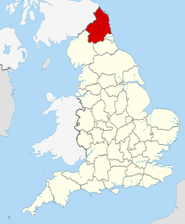
The River Rother, a waterway in the northern midlands of England, gives its name to the town of Rotherham and to the Rother Valley parliamentary constituency. It rises near Clay Cross in Derbyshire and flows in a generally northwards direction through the centre of Chesterfield, where it feeds the Chesterfield Canal, and on through the Rother Valley Country Park and several districts of Sheffield before joining the River Don at Rotherham in Yorkshire.

Macquarie River river in New South Wales, Australia

Macquarie River a watercourse that is part of the Macquarie–Barwon catchment within the Murray–Darling basin, is one of the main inland rivers in New South Wales, Australia.

Moree, New South Wales Town in New South Wales, Australia

Moree is a town in Moree Plains Shire in northern New South Wales, Australia. It is located on the banks of the May may River, in the centre of the Jim plains. Its name comes from an Aboriginal word for “rising sun,” “long spring,” or “water hole.”

Avoca River river in Victoria, Australia

The Avoca River, an inland intermittent river of the north–central catchment, part of the Murray-Darling basin, is located in the lower Riverina bioregion and Central Highlands and Wimmera regions of the Australian state of Victoria. The headwaters of the Avoca River rise on the northern slopes of the Pyrenees Range and descend to flow into the ephemeral Kerang Lakes.

River Anker river in Warwickshire, United Kingdom

The River Anker is a river in England that flows through the centre of Nuneaton. It is a major tributary of the River Tame, which it joins in Tamworth. The name of the river derives from an old British term for winding river. From source to river mouth at Tamworth is 50 kilometres (31 mi).

Stanley River (Queensland) river in Queensland, Australia

The Stanley River is a perennial river located in the South East region of Queensland, Australia. A major tributary of the Brisbane River, the Stanley River valley extends roughly 35 kilometres (22 mi) westwards from the area south of Maleny, through Woodford to Kilcoy before veering southwards.

Georgina River river in Australia

The Georgina River is the north-westernmost of the three major rivers of the Channel Country in Central West Queensland, that also flows through a portion of the Northern Territory, in central Australia. Part of the Lake Eyre basin, the Georgina flows in extremely wet years into Lake Eyre.

2004 Boscastle flood

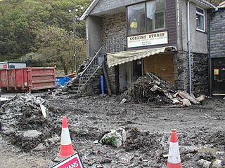
The 2004 Boscastle flood occurred on Monday, 16 August 2004 in the two villages of Boscastle and Crackington Haven in Cornwall, England, United Kingdom. The villages suffered extensive damage after flash floods caused by an exceptional amount of rain that fell over eight hours that afternoon. The flood in Boscastle was filmed and extensively reported but the floods in Crackington Haven and Rocky Valley were not mentioned beyond the local news. The floods were the worst in local memory. A study commissioned by the Environment Agency from hydraulics consulting firm HR Wallingford concluded that it was among the most extreme ever experienced in Britain. The peak flow was about 140 m³/s, between 5:00pm and 6:00pm BST. The annual chance of this flood in any one year is about 1 in 400. The probability each year of the heaviest three-hour rainfall is about 1 in 1300. At midday on 16 August 2004, heavy thundery showers had developed across the South West due to a weak disturbance to the northeast of the United Kingdom.

2007 United Kingdom floods June-July 2007 floods series in the UK

A series of large floods occurred in parts of the United Kingdom during the summer of 2007. The worst of the flooding occurred across Scotland on 14 June; East Yorkshire and The Midlands on 15 June; Yorkshire, The Midlands, Gloucestershire, Herefordshire and Worcestershire on 25 June; and Gloucestershire, Herefordshire, Worcestershire, Oxfordshire, Berkshire and South Wales on 28 July 2007.

Early 2011 Victorian floods

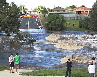
High intensity rainfall between 12–14 January 2011 caused major flooding across much of the western and central parts of the Australian state of Victoria. Several follow-up heavy rainfall events including Tropical Low Yasi caused repeated flash flooding in affected areas in early February in many of the communities affected by January's floods.

River Swift river in the United Kingdom, tributary of the Avon in Warwickshire

The River Swift is a 14-mile (23 km) long tributary of the River Avon that rises in south Leicestershire, and flows through the town of Lutterworth before joining the Avon at its confluence in Warwickshire in the English Midlands.

2013 Alberta floods floods in Southern Alberta in 2013

In the days leading up to June 19, 2013, Alberta, Canada, experienced heavy rainfall that triggered catastrophic flooding described by the provincial government as the worst in Alberta's history. Areas along the Bow, Elbow, Highwood, Red Deer, Sheep, Little Bow, and South Saskatchewan rivers and their tributaries were particularly affected. A total of 32 states of local emergency were declared and 28 emergency operations centres were activated as water levels rose and numerous communities were placed under evacuation orders.

River Isbourne river in Gloucestershire, United Kingdom

The River Isbourne is 14 mile (22 km) long tributary of the River Avon which flows through Gloucestershire and Worcestershire in the Midlands of England.

Markeaton Brook river in the United Kingdom

The Markeaton Brook is an 11-mile-long (17 km) tributary of the River Derwent in Derbyshire, England. The brook rises from its source south of Hulland Ward, and flows for most of its length through the countryside north-west of Derby before entering a culvert to the north of the city centre; it reappears from this culvert and runs through a short section of open channel on the other side of the city before joining the Derwent.

Eller Beck

Eller Beck is a small river in North Yorkshire, England, which flows through the town of Skipton and is a tributary of the River Aire. Its channel was heavily modified to supply water for milling in the eighteenth and nineteenth centuries, and although all milling has ceased, the water now supplies power to the National Grid, generated by a turbine at High Corn Mill. There are several underground culverts within the town, and these contribute to the flood risk. In order to alleviate flooding in Skipton town centre, a scheme involving two flood water storage reservoirs has been designed, but the start of the work to implement it was delayed in October 2014 by a shortfall in funding for the project.

Pickering Beck

Pickering Beck is a river that runs for over 18 miles (29 km) from its source in the North York Moors National Park through the town of Pickering and on to its confluence with Costa Beck at Kirby Misperton. It is a meandering river that is fed by numerous named and unnamed becks and streams which flow over sandstone and limestone beds and an alluvia of sand, clay silt and gravel. The beck is known for flooding and in recent times has been a beneficiary of funding and experimental flood protection schemes.

References

  1. 1 2 3 Morpeth Herald "Worst on Record" Thursday 11 September 2008
  2. "Klassische Wolkenstruktur von Tief 'Mattea'" (in German). donnerwetter.de. Retrieved 23 May 2012.
  3. "England struck by flash flooding". BBC. Retrieved 23 May 2012.
  4. 1 2 BBC News "Flood clean-up operation begins" Monday 8 September 2008
  5. T Willison, Environment Agency Regional Director
  6. 1 2 Environment Agency, Wansbeck and Blyth Catchment Flood Management Plan
  7. BBC News 'Morpeth a scene of devastation' Sunday 7 September 2008
  8. 1 2 Weaver, Matthew; Wainwright, Martin (8 September 2008). "Flood damage to cost 'tens of millions'" . Retrieved 7 November 2018.
  9. "Morpeth Flood Appeal tops £20,000", Morpeth Herald , Wednesday 10 September 2008.