
Thrissur, formerly Trichur, also known by its historical name Thrissivaperur, is a city and the headquarters of the Thrissur district in Kerala, India. It is the third largest urban agglomeration in Kerala after Kochi and Kozhikode, and the 21st largest in India. The city is built around a 65-acre (26 ha) hillock called the Thekkinkaadu Maidaanam which seats a large Hindu Shiva Temple. It is located central of the state, and 304 kilometres (189 mi) north-west of the state's capital city, Thiruvananthapuram. Thrissur was once the capital of the Kingdom of Cochin, and was a point of contact for the Assyrians, Greeks, Persians, Arabs, Romans, Portuguese, Dutch and English.

Palakkad District, in the southeastern part of the former Malabar district, is one of the 14 districts of the Indian state of Kerala. It is located right in the middle of the state. Also, it is the largest district in Kerala since 2006. The city of Palakkad is the district headquarters. Palakkad is bordered on the northwest by the Malappuram District, on the southwest by the Thrissur District, on the northeast by Nilgiris District, and on the east by Coimbatore district of Tamil Nadu. The district is nicknamed "the granary of Kerala". Palakkad is the gateway to Kerala due to the presence of the Palakkad Gap, in the Western Ghats. The 2,383 m high Anginda peak, which is situated in the border of Palakkad district, Nilgiris district, and Malappuram district, in Silent Valley National Park, is the highest point of elevation in Palakkad district. Palakkad city is located just 50 km away from Coimbatore, a major city in Tamil Nadu state.

Pattambi is a town, taluk, and municipality at the western end of the Palakkad district of the state of Kerala, India. It is also the headquarters of the Pattambi Taluk.

Thrissur, is a district of Kerala situated in the central part the state. Spanning an area of about 3,032 km2 (1,171 sq mi), Thrissur district is home to over 9% of Kerala's population.
Avinissery is a census town in Thrissur district, just 6 km from district headquarters, in the state of Kerala, India. Avinisseri is also the name of a Gram Panchayat in Thrissur District.

Chavakkad, formerly Chowghat, is a municipality in Thrissur district of Kerala state in India. It is a suburban town of Thrissur city. Chavakkad is noted for its beach and fishing. It lies on National Highway 66 is located about 75 km (47 mi) north of the city of Kochi, 25 km (16 mi) northwest of Thrissur, and 24 km (15 mi) south of Ponnani.

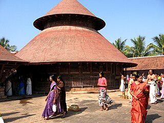
Vazhappally is a suburb of Changanasserry Municipality, Kottayam District, in central Kerala. The famous Vazhappally Shiva Temple is situated in Vazhappally. Vazhappally is a part of Changanacherry Taluk in Kottayam District. It is located in the city of Changanacherry and Vazhappally Panchayath. The ancient Vazhappally gramam (village) was shifted to the Changanassery Municipality, so small portions of the village were reunited in the Municipal Town of Changanassery, while the rest were reconstructed in the Vazhappally Gram Panchayat.
Ayyampuzha is a village and panchayat in Angamaly Ernakulam district in the Indian state of Kerala. Kalady plantations is a part of the panchaayat.
Kalpakanchery is a revenue village and a Gram Panchayat in Tirur Taluk, Malappuram district, Kerala, India. The village is located 21 kilometres (13 mi) south-west to the city of Malappuram.
Kollengode is a town in Palakkad district, Kerala, India. Kollengode is well known for the culture of Kerala. Kollengode Town is the head quarter of Kollengode Sub District, Kollengode Panchayat and Kollengode Block Panchayat. Kollengode is one of the major tourist spots of Palakkad district. Kollengode has contributed many famous personalities to the society in the fields of movies, cultural activists, social activists, musicians, writers, poets, scholars, and so on.
Vandithavalam is a village in the Palakkad district, state of Kerala, India. It is among the villages administered by the Perumatty Gram Panchayat.
Annakara is a village in Thrissur district in the state of Kerala, India. Located on the western bank of Kechery river, it was earlier a border village, located near the junction of Malabar region of Madras presidency and Kochi kingdom. Annakara village comes under Mullassery Grama Panchayat. Chirakkal Bagavathy temple is located in this village.
Anthikad is a village in Thrissur district in the state of Kerala, India. It is in Thrissur Thaluk, Nattika constituency and Anthikad Block. Manalur and Thanyam are the nearest panchayats. Anthikad is famous for toddy production and paddy fields. Anthikad won `Nelkathir' award for best paddy cultivation in kelara in 2008. Anthikad is the headquarter for a major financial enterprise, the Peringottukara Namboothiri Yogashkema Sabha Credit & Investment Company Ltd., which was formed in the year 1907. Headquarters of India's biggest gold loan company, Manapuram Finance Ltd. is also located here.
Chazhoor (Chazhur) is a village in Thrissur Taluk of Thrissur district in the state of Kerala, India. Thriprayar (4 km), Thrissur (22 km), and Chavakkad (17 km) are nearby cities. Chazhoor is 4 km away from Snehatheeram beach.
Engandiyur is a village in the Chavakkad taluka of the Thrissur district in the state of Kerala, India. It has an area of 1411 hectares and harbours 5,760 households with total population of 23,101 as per the 2011 Census. The nearest town Chavakkad is at a distance of 8 km. Male population is 10,528 and female population is 12,573. Scheduled Caste Population is 615 and Scheduled Tribes population is 45. Census Location Code of the village is 627789.
Mullassery is a village in Thrissur district in the state of Kerala, India. It is located 17Km west of District Headquarters Thrissur and 290Km from the state capital Thiruvanathapuram. It houses Parambanthali Mahadeva temple, Good Shepherd's Church and Our Lady of Mount Carmel Church. The nearest railheads are at Guruvayoor and Thrissur. Nearby airports are Cochin International Airport and Calicut Airport. Parambanthali Shashti is a famous festival celebrated in the village. Mullassery has a wetland ecosystem which is known as Kole lands. These Kole lands are considered rice granaries.Mullassery is an agricultural village however, today majority of youth of this village are UAE expatriates.
Pazhanji is a village Postal code : 680542 near Kunnamkulam in Thrissur district in the state of Kerala, India.The name "Pazhanji" is derived from the Malayalam word for "old".

Vadanappally (Vatanappilly/Vadanapally) is a panchayat and census town in Thrissur district, in the state of Kerala, India.It is a suburb of Thrissur city.
Kolazhy Grama Panchayat, also known as Kolazhy GP, is part of Puzhakkal block, in Thrissur taluk, in Thrissur district. It is located 6.8 kilometres (4.2 mi) north of Thrissur city.

