{{lang|sv|Kannonkoski kommun}}"},"settlement_type":{"wt":"Municipality"},"image_skyline":{"wt":"Kannonkoski Leppäkyläntie 20190619.jpg"},"imagesize":{"wt":""},"image_caption":{"wt":""},"image_shield":{"wt":"Kannonkoski.vaakuna.svg"},"shield_size":{"wt":"120x80px"},"image_map":{"wt":"Kannonkoski sijainti Suomi.svg"},"map_caption":{"wt":"Location of Kannonkoski in Finland"},"coordinates":{"wt":"{{coord|62|58.5|N|025|16|E|display=inline,title}}"},"subdivision_type":{"wt":"Country"},"subdivision_name":{"wt":"{{flag|Finland}}"},"subdivision_type1":{"wt":"[[Regions of Finland|Region]]"},"subdivision_name1":{"wt":"[[Central Finland]]"},"subdivision_type2":{"wt":"[[Sub-regions of Finland|Sub-region]]"},"subdivision_name2":{"wt":"Saarijärvi–Viitasaari sub-region"},"leader_title":{"wt":"Municipal manager"},"leader_name":{"wt":"Maarit Autio"},"established_title":{"wt":"[[Charter]]"},"established_date":{"wt":"1934"},"area_footnotes":{"wt":"{{Data Finland municipality|area_footnotes|Kannonkoski}}"},"area_total_km2":{"wt":"{{Data Finland municipality|area_total_km2|Kannonkoski}}"},"area_land_km2":{"wt":"{{Data Finland municipality|area_land_km2|Kannonkoski}}"},"area_water_km2":{"wt":"{{Data Finland municipality|area_water_km2|Kannonkoski}}"},"area_rank":{"wt":"{{Data Finland municipality|area_rank|Kannonkoski}}"},"population_as_of":{"wt":"{{Data Finland municipality|population_as_of|Kannonkoski}}"},"population_footnotes":{"wt":"{{Data Finland municipality|population_footnotes|Kannonkoski}}"},"population_total":{"wt":"{{Data Finland municipality|population_total|Kannonkoski}}"},"population_density_km2":{"wt":"{{Data Finland municipality|population_density_km2|Kannonkoski}}"},"population_rank":{"wt":"{{Data Finland municipality|population_rank|Kannonkoski}}"},"demographics_type1":{"wt":"{{Data Finland municipality|demographics_type1|Kannonkoski}}"},"demographics1_footnotes":{"wt":"{{Data Finland municipality|population_footnotes|Kannonkoski}}"},"demographics1_title1":{"wt":"{{Data Finland municipality|demographics1_title1|Kannonkoski}}"},"demographics1_info1":{"wt":"{{Data Finland municipality|demographics1_info1|Kannonkoski}}"},"demographics1_title2":{"wt":"{{Data Finland municipality|demographics1_title2|Kannonkoski}}"},"demographics1_info2":{"wt":"{{Data Finland municipality|demographics1_info2|Kannonkoski}}"},"demographics1_title3":{"wt":"{{Data Finland municipality|demographics1_title3|Kannonkoski}}"},"demographics1_info3":{"wt":"{{Data Finland municipality|demographics1_info3|Kannonkoski}}"},"demographics1_title4":{"wt":"{{Data Finland municipality|demographics1_title4|Kannonkoski}}"},"demographics1_info4":{"wt":"{{Data Finland municipality|demographics1_info4|Kannonkoski}}"},"demographics_type2":{"wt":"{{Data Finland municipality|demographics_type2|Kannonkoski}}"},"demographics2_footnotes":{"wt":"{{Data Finland municipality|demographics2_footnotes|Kannonkoski}}"},"demographics2_title1":{"wt":"{{Data Finland municipality|demographics2_title1|Kannonkoski}}"},"demographics2_info1":{"wt":"{{Data Finland municipality|demographics2_info1|Kannonkoski}}"},"demographics2_title2":{"wt":"{{Data Finland municipality|demographics2_title2|Kannonkoski}}"},"demographics2_info2":{"wt":"{{Data Finland municipality|demographics2_info2|Kannonkoski}}"},"demographics2_title3":{"wt":"{{Data Finland municipality|demographics2_title3|Kannonkoski}}"},"demographics2_info3":{"wt":"{{Data Finland municipality|demographics2_info3|Kannonkoski}}"},"blank_name":{"wt":"{{Data Finland municipality|blank_name|Kannonkoski}}"},"blank_info":{"wt":"{{Data Finland municipality|blank_info|Kannonkoski}}"},"timezone":{"wt":"[[Eastern European Time|EET]]"},"utc_offset":{"wt":"+02:00"},"timezone_DST":{"wt":"[[Eastern European Summer Time|EEST]]"},"utc_offset_DST":{"wt":"+03:00"},"website":{"wt":"{{Url|https://www.kannonkoski.fi/}}"}},"i":0}}]}" id="mwBw">Municipality in Central Finland, Finland
Kannonkoski | |
---|---|
Municipality | |
Kannonkosken kunta Kannonkoski kommun | |
![]() | |
![]() Location of Kannonkoski in Finland | |
Coordinates: 62°58.5′N025°16′E / 62.9750°N 25.267°E | |
Country | ![]() |
Region | Central Finland |
Sub-region | Saarijärvi–Viitasaari sub-region |
Charter | 1934 |
Government | |
• Municipal manager | Maarit Autio |
Area (2018-01-01) [1] | |
• Total | 549.88 km2 (212.31 sq mi) |
• Land | 445 km2 (172 sq mi) |
• Water | 104.87 km2 (40.49 sq mi) |
• Rank | 196th largest in Finland |
Population (2023-12-31) [2] | |
• Total | 1,217 |
• Rank | 285th largest in Finland |
• Density | 2.73/km2 (7.1/sq mi) |
Population by native language | |
• Finnish | |
• Swedish | |
• Others | |
Population by age | |
• 0 to 14 | |
• 15 to 64 | |
• 65 or older | |
Time zone | UTC+02:00 (EET) |
• Summer (DST) | UTC+03:00 (EEST) |
Website | www |
Kannonkoski is a Finnish municipality located in the Central Finland region. The municipality has a population of 1,217 (31 December 2023) [2] and covers an area of 549.88 square kilometres (212.31 sq mi) of which 104.87 km2 (40.49 sq mi), or 19%, is water. [1] The population density is 2.73 inhabitants per square kilometre (7.1/sq mi). Neighbouring municipalities are Karstula, Kivijärvi, Saarijärvi, Viitasaari and Äänekoski.
The municipality is unilingually Finnish.
Kannonkoski as a settlement name is very new, originally only referring to the rapids which connect the lake Kannonjärvi to the lake Kivijärvi. The toponym kannonn Maa[ sic ] was mentioned in 1552, referring to hunting grounds of the people of Sysmä in this area. The people of Pälkäne also had hunting grounds around the rapids and the name Kannonkoski may be derived from Kantokylä, a village in Pälkäne. By 1558 the area had got permanent Savonian settlers, who established the village of Kantojärvi (transcribed as Kandoijerffuij). Rautalampi, including this area, became a separate parish in 1561.
Viitasaari was separated from Rautalampi in 1635. At the time, it included all of the villages that would later become parts of the municipality of Kannonkoski. Kivijärvi was split off from Viitasaari in 1904.
In 1919 it was decided that the area should get its own parish, which happened in 1931. The parish was formed from parts of Viitasaari and Kivijärvi. The area became a municipality in 1934. The church and administrative center were placed in the village of Pudasjärvi, however because a municipality called Pudasjärvi already existed, the new municipality was named Kannonkoski after the nearby rapids. [4]
During the Winter War, 117 monks from the Valamo monastery in the lake Ladoga were evacuated. They arrived in Kannonkoski in 1939, bringing various icons and relics with them. The monks lived in the Piispala school, which at the time was closed due to the ongoing war.
The monks left Kannonkoski in the autumn of 1940 after they had purchased an old manor in Heinävesi, where the New Valamo monastery was soon established. 27 monks died during the evacuation and were buried in the graveyard of the Lutheran Kannonkoski church. [5]
Kannonkoski, Karstula, Kivijärvi and Kyyjärvi planned to merge into the Suomenselkä municipality from January 1, 2022. [6] [7] Karstula, Kivijärvi and Kyyjärvi accepted the merger proposal, but Kannonkoski did not. [8] After Kannonkoski left out of the planned merger, Kivijärvi also left out, and later the merger project of the remaining Karstula and Kyyjärvi failed at the Kyyjärvi municipal council meeting held on May 17, 2021, and the Ministry of Finance does not propose a forced merger either. [9]
There are all together 81 lakes in Kannonkoski. Biggest lakes are Kivijärvi, Vuosjärvi and Kannonselkä. [10]
Western Finland was a province of Finland from 1997 to 2009. It bordered the provinces of Oulu, Eastern Finland and Southern Finland. It also bordered the Gulf of Bothnia towards Åland. Tampere was the largest city of the province.
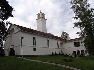
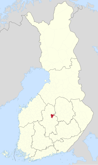
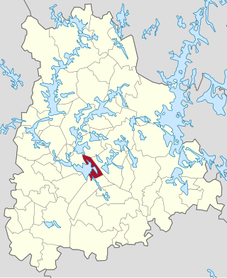
Muurame is a municipality of Finland, located 16 kilometres (10 mi) south-west of Jyväskylä. Muurame itself is located between two lakes, Lake Päijänne and Lake Muuratjärvi. These two lakes are connected to each other via River Muurame. All together there are 37 lakes in Muurame. Biggest lakes beside Päijänne are Muuratjärvi and Lake Kuusjärvi. River Muurame streams through the population center of Muurame. Muurame was founded in 1921.
The former Province of Western Finland in Finland was divided into seven regions, 34 districts and 192 municipalities.
Äänekoski is a town in Finland. It is located in the Central Finland region, about 45 kilometres (28 mi) north of Jyväskylä, the region's capital city. Äänekoski has a population of 17,971, as of 31 December 2023, and covers an area of 1,138.39 square kilometres (439.53 sq mi) of which 253.84 km2 (98.01 sq mi), or 22%, is water. The population density is 20.32 inhabitants per square kilometre (52.6/sq mi).
The 23 municipalities of the Central Finland Region in Finland are divided on six sub-regions.
Karstula is a municipality of Finland founded in 1867. It is located in the Central Finland region. The municipality has a population of 3,625 and covers an area of 963.19 square kilometres (371.89 sq mi) of which 76.22 km2 (29.43 sq mi) is water. The population density is 4.09 inhabitants per square kilometre (10.6/sq mi).
Keuruu is a town and municipality of Finland. It is located in the province of Western Finland and is part of the Central Finland region. The municipality has a population of 9,184 and covers an area of 1,430.57 square kilometres (552.35 sq mi) of which 172.4 km2 (66.6 sq mi) is water. The population density is 7.3 inhabitants per square kilometre (19/sq mi). The town center and Haapamäki village are both the most populated places in Keuruu.
Kivijärvi is a municipality of Finland. It is located in the Central Finland region. The municipality has a population of 1,035 and covers an area of 599.88 square kilometres (231.61 sq mi) of which 115.81 km2 (44.71 sq mi) is water. The population density is 2.14 inhabitants per square kilometre (5.5/sq mi).
Kyyjärvi is a municipality of Finland. It is located in the Central Finland region, about 120 kilometres (75 mi) northwest of Jyväskylä. The municipality has a population of 1,174 and covers an area of 469.61 square kilometres (181.32 sq mi) of which 21.39 km2 (8.26 sq mi) is water. The population density is 2.62 inhabitants per square kilometre (6.8/sq mi). The municipality is unilingually Finnish.
Central Finland is a region in Finland. It borders the regions of Päijät-Häme, Pirkanmaa, South Ostrobothnia, Central Ostrobothnia, North Ostrobothnia, North Savo, and South Savo. The city of Jyväskylä is the regional centre and by far the largest city in the area. The Central Finland lies slightly south of the geographical centre of Finland. The landscape is hilly and a large part of the province belongs to the Finnish Lakeland.
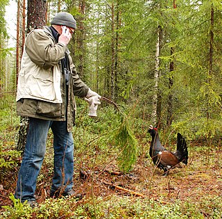
Pihtipudas is a municipality of Finland. Pihtipudas is known for the annual javelin carnival and for Lauri "Tahko" Pihkala, the inventor of Pesäpallo, the Finnish variant of baseball.
Rautalampi is a municipality of Finland. It is located in the Northern Savonia region. The municipality has a population of 2,933 and covers an area of 761.98 square kilometres (294.20 sq mi) of which 222.99 km2 (86.10 sq mi) is water. The population density is 5.44 inhabitants per square kilometre (14.1/sq mi). The municipality is unilingually Finnish.
Saarijärvi is a town and municipality of Finland located in the Central Finland region. The municipality has a population of 8,847, as of 31 December 2023, and covers an area of 1,422.72 square kilometres (549.32 sq mi) of which 170.8 km2 (65.9 sq mi), or 12%, is water. The population density is 7.07 inhabitants per square kilometre (18.3/sq mi).
Viitasaari is a Finnish town and municipality located in the Central Finland region. The town has a population of 5,877 (31 December 2023) and covers an area of 1,589.13 square kilometres (613.57 sq mi) of which 340.43 km2 (131.44 sq mi), or 21%, is water. There are all together 230 lakes in Viitasaari. The biggest lakes are Lake Keitele, Lake Kolima and Muuruejärvi. The population density is 4.71 inhabitants per square kilometre (12.2/sq mi).
The Central Finland Province was a province of Finland from 1960 to 1997. The area of the Central Finland Province was the same as the area of Central Finland region.
Perhonjoki is a river of Finland in Central Ostrobothnia region. It originates in Suomenselkä from the small lakes on the border of the municipalities of Perho, Kyyjärvi and Kivijärvi, and it flows for 114 kilometres (71 mi) into the Gulf of Bothnia.
Vuosjärvi is a medium-sized lake of Finland in northern Central Finland, Kannonkoski and Viitasaari. The water flows from Lake Kivijärvi through Hilmo Power Station and the water continues to the Huopanankoski rapids. Near the power station there are Hilmonjoki rapids, too. The lake is quite shallow and good for fishing lake forells and zanders.
Saarijärvi-Viitasaari sub-region is a subdivision of Central Finland and one of the Sub-regions of Finland since 2009.
Konginkangas is a settlement and former municipality of Finland in the Central Finland region. It was consolidated with Äänekoski in 1993.
Tyrväntö is a former municipality of Finland in the Häme Province, now in Tavastia Proper. It was consolidated with Hattula in 1971. The northern part of the former municipality was transferred to Valkeakoski in 1978.