Pälkäne

Last updated • 2 min readFrom Wikipedia, The Free Encyclopedia
Pälkäne
Municipality
Pälkäneen kunta
Pälkäne kommun
Palkane church 1545442.jpg
Ruins of the medieval church in Pälkäne
Palkane uusi.svg
Palkane sijainti Suomi.svg
Location of Pälkäne in Finland
Coordinates: 61°20.3′N024°16′E / 61.3383°N 24.267°E / 61.3383; 24.267
CountryFlag of Finland.svg  Finland
Region Pirkanmaa
Sub-region Tampere sub-region
Charter 1866
Seat Onkkaala
Government
  Municipal managerPauliina Pikka
Area
 (2018-01-01) [1]
  Total
738.15 km2 (285.00 sq mi)
  Land560.71 km2 (216.49 sq mi)
  Water177.65 km2 (68.59 sq mi)
  Rank 152nd largest in Finland
Population
 (2024-10-31) [2]
  Total
6,251
  Rank 148th largest in Finland
  Density11.15/km2 (28.9/sq mi)
Population by native language
[3]
   Finnish 95.7% (official)
   Swedish 0.4%
  Others3.9%
Population by age
[4]
  0 to 1414.5%
  15 to 6455.9%
  65 or older29.5%
Time zone UTC+02:00 (EET)
  Summer (DST) UTC+03:00 (EEST)
Website www.palkane.fi OOjs UI icon edit-ltr-progressive.svg

Pälkäne (Finnish pronunciation: [ˈpælkæne] ) is a municipality of Finland. It is part of the Pirkanmaa region. The municipality has a population of 6,251 (31 October 2024) [2] and covers an area of 738.15 square kilometres (285.00 sq mi) of which 177.65 km2 (68.59 sq mi). [1] The population density is 11.15 inhabitants per square kilometre (28.9/sq mi). Onkkaala is the administrative center of the municipality. Tampere is located 38 kilometres (24 mi) northwest of the center of Pälkäne.

Contents

The municipality is unilingually Finnish. Many people from Helsinki and the surrounding cities own summer cottages and residences in Pälkäne, making the small town very busy during summer vacation seasons. Pälkäne is a very popular summer vacation resort given its diverse services, high-quality swimming beach, beautiful nature and close location to big cities. From start of year 2007 Pälkäne and Luopioinen were merged to a new municipality of Pälkäne.

Geography

Nature

Kostianvirta flows through Palkane Kostianvirta3.jpg
Kostianvirta flows through Pälkäne

The landscape of Pälkäne is dominated by several lakes, the largest of which are Lake Mallasvesi on the west side of Onkkaala and Lake Pälkänevesi on its east side, as well as Lake Roine on the Kangasala side and Lake Ilmoilanselkä on the Hauho (Hämeenlinna) side. Lake Kukkia is situated in the area of the former municipality of Luopioinen. In the western part of Pälkäne, Roine and Mallasvesi are separated by the rather large island of Hausalo. [5]

The Kostianvirta River, which belongs part to the drainage basin of the Kokemäki River, flows between Lake Pälkänevesi and Lake Mallasvesi. [6] As the average water level of both lakes is about 84 meters above sea level, the flow direction of Kostianvirta sometimes changes, especially due to the spring meltwater. [7]

Villages

  • Äimälä
  • Aitoo
  • Ämmätsä
  • Epaala
  • Evinsalo
  • Haltia
  • Harhala
  • Huhtioinen
  • Huntila
  • Kaitamo
  • Kajantila
  • Kankahainen
  • Kantokylä
  • Kantola
  • Kärväntälä
  • Karviala
  • Kaukkala
  • Kinnala
  • Kirpu
  • Kollola
  • Kotila
  • Kouvala
  • Kuisema
  • Kukkola
  • Kuohijoki
  • Kuuliala
  • Kyynärö
  • Laitikkala
  • Lemmettylä
  • Lovensalo
  • Luikala
  • Luopioinen
  • Mälkilä
  • Mällinoja
  • Miemola
  • Mustilahti
  • Myttäälä
  • Okerla
  • Oksala
  • Onkkaala
  • Padankoski
  • Pappila
  • Pitkäjärvi
  • Pohjalahti
  • Puutikkala
  • Rautajärvi
  • Ruokola
  • Ruotsila
  • Sairiala
  • Salmentaka
  • Sappee
  • Säynäjärvi
  • Seitsye
  • Tauriala
  • Tausti
  • Tommola
  • Töyräniemi
  • Vahdermetsä
  • Vuolijoki

Culture

A former coat of arms of Palkane Palkane.vaakuna.1965.svg
A former coat of arms of Pälkäne

Food

In the 1980s, Pälkäne's traditional parish dishes were called local sweetened potato casserole called tuuvinki, salted bream, slowly smoked meat, Tavastian limppu bread called varikoinen, [8] sweet sahti, and plum kissel. [9]

People

See also

Related Research Articles

<span class="mw-page-title-main">Kirkkonummi</span> Municipality in Uusimaa, Finland

Kirkkonummi is a municipality in Finland, located in the southern coast of the country. Kirkkonummi is situated in the western part of the Uusimaa region. The population of Kirkkonummi is approximately 42,000. It is the 28th most populous municipality in Finland. Kirkkonummi is part of the Helsinki Metropolitan Area, which has approximately 1.6 million inhabitants.

<span class="mw-page-title-main">Asikkala</span> Municipality in Päijänne Tavastia, Finland

Asikkala is a municipality of Finland. Its seat is in Vääksy, at the shores of the Lake Päijänne. It is located in the province of Southern Finland and is part of the Päijänne Tavastia region. Asikkala's neighboring municipalities are Hämeenlinna, Heinola, Hollola, Lahti, Padasjoki and Sysmä.

<span class="mw-page-title-main">Vaala</span> Municipality in North Ostrobothnia, Finland

Vaala is a municipality in Finland. It is located in the North Ostrobothnia region. Established in 1954, the municipality has a population of 2,574 and covers an area of 1,764.04 square kilometres (681.10 sq mi) of which 461.45 km2 (178.17 sq mi) is water. The population density is 1.98 inhabitants per square kilometre (5.1/sq mi). Previously Vaala was part of the Kainuu region but was transferred to Northern Ostrobothnia on 1 January 2016.

<span class="mw-page-title-main">Valkeakoski</span> Town in Pirkanmaa, Finland

Valkeakoski is a town and municipality in Finland. It is located 35 kilometres (22 mi) south of Tampere, 45 km (28 mi) north of Hämeenlinna and 150 km (93 mi) north of Helsinki in the Pirkanmaa region. The municipality has a population of 20,816 (31 October 2024) and covers an area of 372.03 square kilometres (143.64 sq mi) of which 100.06 km2 (38.63 sq mi) is water. The population density is 76.52 inhabitants per square kilometre (198.2/sq mi).

<span class="mw-page-title-main">Vihti</span> Municipality in Uusimaa, Finland

Vihti is a municipality in Finland, located in the southern interior of the country. Vihti is situated in the Uusimaa region. The population of Vihti is approximately 29,000. It is the 37th most populous municipality in Finland. Vihti is part of the Helsinki metropolitan area, which has approximately 1.6 million inhabitants.

<span class="mw-page-title-main">Heinävesi</span> Municipality in North Karelia, Finland

Heinävesi is a municipality of Finland. It is located in the North Karelia region. The municipality has a population of 2,938 and covers an area of 1,319.58 square kilometres (509.49 sq mi) of which 288.71 km2 (111.47 sq mi) is water. The population density is 2.85 inhabitants per square kilometre (7.4/sq mi). Neighbouring municipalities are Savonlinna, Varkaus, Leppävirta, Tuusniemi, Outokumpu and Liperi. The city of Joensuu is located 81 kilometres (50 mi) northeast of Heinävesi. The municipality is unilingually Finnish.

<span class="mw-page-title-main">Hirvensalmi</span> Municipality in Southern Savonia, Finland

Hirvensalmi is a municipality of Finland.

<span class="mw-page-title-main">Lapinlahti</span> Municipality in Northern Savonia, Finland

Lapinlahti is a municipality of Finland. It is part of the Northern Savonia region, located 59 kilometres (37 mi) north of the city of Kuopio. The municipality has a population of 8,869 and covers an area of 1,245.16 square kilometres (480.76 sq mi) of which 148.58 km2 (57.37 sq mi) is water. The population density is 8.09 inhabitants per square kilometre (21.0/sq mi). The municipality is unilingually Finnish.

<span class="mw-page-title-main">Loppi</span> Municipality in Tavastia Proper, Finland

Loppi is a municipality in Finland. It is located in the province of Southern Finland and is part of the Kanta-Häme region, located about 50 kilometers south of the city of Hämeenlinna. Loppi was founded in 1632. The municipality has a population of 7,670 and covers an area of 655.97 square kilometres (253.27 sq mi) of which 58.36 km2 (22.53 sq mi) is water. The population density is 12.83 inhabitants per square kilometre (33.2/sq mi). The municipality is unilingually Finnish.

<span class="mw-page-title-main">Orivesi</span> Town of Orivesi in Pirkanmaa, Finland

Orivesi is a town in Finland, located in the Pirkanmaa region. It lies to the northeast of the regional capital, Tampere. The population of Orivesi is approximately 9,000, while the metropolitan area has a population of approximately 423,000. It is the 111th most populous municipality in Finland.

<span class="mw-page-title-main">Pielavesi</span> Municipality in Northern Savonia, Finland

Pielavesi is a municipality of Finland. It is part of the Northern Savonia region. The municipality has a population of 3,994 and covers an area of 1,406.51 square kilometres (543.06 sq mi) of which 253.27 km2 (97.79 sq mi) is water. The population density is 3.46 inhabitants per square kilometre (9.0/sq mi). The municipality is unilingually Finnish.

<span class="mw-page-title-main">Ruovesi</span> Municipality in Pirkanmaa, Finland

Ruovesi is a municipality of Finland.

<span class="mw-page-title-main">Sotkamo</span> Municipality in Kainuu, Finland

Sotkamo is a municipality of Finland, located in the Kainuu region about 40 kilometres (25 mi) east of Kajaani, the capital of Kainuu. Vuokatti, in west of Sotkamo, is the most populous village in the municipality and also a popular skiing resort. Both Hiidenportti National Park and Tiilikkajärvi National Park are located in the municipality.

<span class="mw-page-title-main">Suonenjoki</span> Town in Northern Savonia, Finland

Suonenjoki is a town and municipality of Finland. It is located in the Northern Savonia region, 50 kilometres (31 mi) southwest of Kuopio.

<span class="mw-page-title-main">Säkylä</span> Municipality in Satakunta, Finland

Säkylä is a municipality of Finland. It is located in the Satakunta region, 65 kilometres (40 mi) southeast of the city of Pori. The municipality has a population of 6,288 and the municipality covers an area of 527.71 square kilometres (203.75 sq mi) of which 107.89 square kilometres (41.66 sq mi) is inland water (2018-01-01). The population density is 15 inhabitants per square kilometre (39/sq mi). The municipality is unilingually Finnish.

<span class="mw-page-title-main">Varkaus</span> Town in Northern Savonia, Finland

Varkaus is a Middle-Savonian industrial town and municipality of Finland. It is located in the province of Eastern Finland and is part of the Northern Savonia region, between the city of Kuopio and the town of Savonlinna.

<span class="mw-page-title-main">Vieremä</span> Municipality in Northern Savonia, Finland

Vieremä is a municipality of Finland in the Northern Savonia region. The municipality has a population of 3,361 and covers an area of 973.35 square kilometres (375.81 sq mi) of which 48.2 km2 (18.6 sq mi) is water. The population density is 3.63 inhabitants per square kilometre (9.4/sq mi).

<span class="mw-page-title-main">Virrat</span> Town in southwest Finland

Virrat is a town and municipality of Finland. It is part of the Pirkanmaa region, and it is located 104 kilometres (65 mi) north of Tampere and 113 kilometres (70 mi) west of Jyväskylä. The distance between Virrat and Helsinki is 285 kilometres (177 mi). The town has a population of 6,199 (31 October 2024) and covers an area of 1,299.07 square kilometres (501.57 sq mi) of which 136.73 km2 (52.79 sq mi) is water. The population density is 5.33 inhabitants per square kilometre (13.8/sq mi). The municipality is unilingually Finnish.

<span class="mw-page-title-main">Kuohijärvi</span> Lake in the country of Finland

Kuohijärvi is a lake in Finland. It is part of a chain of lakes that begins from the lakes Lummene and Vesijako at the drainage divide between the Kokemäenjoki and Kymijoki basins, flows westwards from there and drains into lake Mallasvesi through the lakes Kuohijärvi, Kukkia, Iso-Roine, Hauhonselkä and Ilmoilanselkä. The lake is part of the Kokemäenjoki basin and is located for the biggest part in the area of the city of Hämeenlinna in the Tavastia Proper region and for a smaller part in the municipality of Pälkäne in the Pirkanmaa region.

<span class="mw-page-title-main">Onkkaala</span> Village in Pirkanmaa, Finland

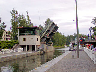
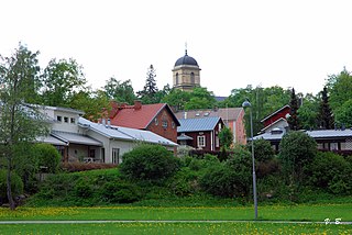
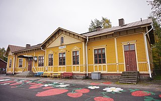
Onkkaala is a village and the administrative center of the Pälkäne municipality in Pirkanmaa, Finland. At the end of 2020, the village had a population of 2,569. Onkkaala is situated on the isthmus between Lake Pälkänevesi and Lake Mallasvesi, through which the Kostianvirta River flows, connecting the two lakes. Highway 12, linking cities of Tampere and Lahti, passes through Onkkaala.

References

  1. 1 2 "Area of Finnish Municipalities 1.1.2018" (PDF). National Land Survey of Finland. Retrieved 30 January 2018.
  2. 1 2 "Finland's preliminary population figure was 5,635,560 at the end of October 2024". Population structure. Statistics Finland. 2024-11-19. ISSN   1797-5395 . Retrieved 2024-11-22.
  3. "Population growth biggest in nearly 70 years". Population structure. Statistics Finland. 2024-04-26. ISSN   1797-5395 . Retrieved 2024-04-29.
  4. "Population according to age (1-year) and sex by area and the regional division of each statistical reference year, 2003–2020". StatFin. Statistics Finland . Retrieved 2 May 2021.
  5. Hannu Tarmio, Pentti Papunen & Kalevi Korpela): Suomenmaa 6: maantieteellis-yhteiskunnallinen tieto- ja hakuteos, p. 337–341. Porvoo-Helsinki: WSOY, 1976. ISBN 951-0-06465-3. (in Finnish)
  6. Kostianvirta - Maanmittauslaitos (in Finnish)
  7. Mäntylä, Jorma (2004). "Sarsan maisema mullistui yhdessä yössä". Tiede (in Finnish). Retrieved October 17, 2021.
  8. Kansallisruuat - Kangasalan Sanomat (in Finnish)
  9. Jaakko Kolmonen: Kotomaamme ruoka-aitta: Suomen, Karjalan ja Petsamon pitäjäruoat, p. 74. Helsinki: Patakolmonen Ky, 1988. (in Finnish)

Commons-logo.svg Media related to Pälkäne at Wikimedia Commons