Karamu, New Zealand

Last updated

Karamu
Rural community
Karamu, New Zealand
Coordinates: 39°38′10″S176°52′48″E / 39.636°S 176.880°E / -39.636; 176.880
Country New Zealand
Region Hawke's Bay
Territorial authority Hastings District
Ward
  • Heretaunga General Ward
  • Kahurānaki General Ward
  • Takitimu Māori Ward
Electorates
Government
  Territorial Authority Hastings District Council
  Regional council Hawke's Bay Regional Council
Area
[1]
  Total13.20 km2 (5.10 sq mi)
Population
 (June 2023) [2]
  Total1,460
  Density110/km2 (290/sq mi)
Postcode(s)
4172

Karamu is a rural community in the Hastings District and Hawke's Bay Region of New Zealand's North Island. The area is on the eastern outskirts of Hastings city.

Karamu Estate covered the area in the 1870s. A dispute over the title was made moot by the challenging solicitor purchasing a large share in the estate. [3] Part of the estate was sold in several farming allotments and residential sites in 1891. [4] Further subdivisions occurred in 1919, [5] and 1924. [6] The remainder was subdivided in 1929. [7]

Demographics

The statistical area of Karamu, which also includes Whakatu, covers 13.20 km2 (5.10 sq mi) [1] and had an estimated population of 1,460 as of June 2023, [2] with a population density of 111 people per km2.

Historical population
YearPop.±% p.a.
20061,179    
20131,218+0.47%
20181,311+1.48%
Source: [8]

Before the 2023 census, the statistical area had a larger boundary, covering 13.29 km2 (5.13 sq mi). [1] Using that boundary, Karamu had a population of 1,311 at the 2018 New Zealand census, an increase of 93 people (7.6%) since the 2013 census, and an increase of 132 people (11.2%) since the 2006 census. There were 417 households, comprising 684 males and 627 females, giving a sex ratio of 1.09 males per female. The median age was 39.4 years (compared with 37.4 years nationally), with 270 people (20.6%) aged under 15 years, 249 (19.0%) aged 15 to 29, 633 (48.3%) aged 30 to 64, and 156 (11.9%) aged 65 or older.

Ethnicities were 69.8% European/Pākehā, 36.6% Māori, 6.6% Pacific peoples, 2.3% Asian, and 1.6% other ethnicities. People may identify with more than one ethnicity.

The percentage of people born overseas was 14.0, compared with 27.1% nationally.

Although some people chose not to answer the census's question about religious affiliation, 47.1% had no religion, 38.7% were Christian, 5.3% had Māori religious beliefs, 0.2% were Buddhist and 0.9% had other religions.

Of those at least 15 years old, 126 (12.1%) people had a bachelor's or higher degree, and 222 (21.3%) people had no formal qualifications. The median income was $32,100, compared with $31,800 nationally. 159 people (15.3%) earned over $70,000 compared to 17.2% nationally. The employment status of those at least 15 was that 615 (59.1%) people were employed full-time, 153 (14.7%) were part-time, and 30 (2.9%) were unemployed. [8]

Related Research Articles

<span class="mw-page-title-main">Hastings, New Zealand</span> City in Hawkes Bay, New Zealand

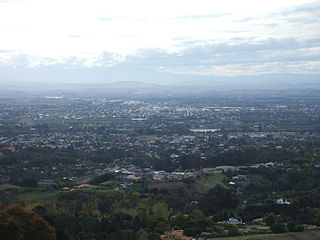
Hastings is an inland city of New Zealand and is one of the two major urban areas in Hawke's Bay, on the east coast of the North Island. The population of Hastings is 51,500, with a further 15,200 people in Havelock North and 2,090 in Clive. Hastings is about 18 kilometres inland of the coastal city of Napier. These two neighbouring cities are often called "The Bay Cities" or "The Twin Cities".

<span class="mw-page-title-main">Havelock North</span> Town in Hawkes Bay Region, New Zealand

Havelock North is a town in the Hawke's Bay region of the North Island of New Zealand, situated less than 2 km south-east of the city of Hastings. It was a borough for many years until the 1989 reorganisation of local government saw it merged into the new Hastings District, and it is now administered by the Hastings District Council.

<span class="mw-page-title-main">Central Hawke's Bay District</span> Territorial authority district in Hawkes Bay, New Zealand

Central Hawke's Bay District is in the Hawke's Bay Region in the North Island of New Zealand. Formed in 1989, it covers an area of 3,333 square kilometres, from Pukehou in the north to Takapau in the south, and from the western Ruahine Range to the Pacific coast in the east. It has a population of 16,000, up from 14,142 in the 2018 census and 12,717 in the 2013 census.

<span class="mw-page-title-main">Waipawa</span> Town in Hawkes Bay, New Zealand

Waipawa is the second-largest town in Central Hawke's Bay in the east of the North Island of New Zealand. It has a population of 2,400.

<span class="mw-page-title-main">Hastings District, New Zealand</span> Territorial authority district in Hawkes Bay Region, New Zealand

Hastings District is a Territorial authority district within the Hawke's Bay Region, on the east coast of the North Island of New Zealand. It covers the southern half of the Hawke's Bay coast, excluding Napier City, which is a separate territorial authority. Hastings District Council is headquartered in the city of Hastings, the district's largest town.

<span class="mw-page-title-main">Pōrangahau</span> Settlement in Hawkes Bay Region, New Zealand

Pōrangahau is a small township close to the Pacific Ocean coast in the south-east of the North Island of New Zealand. It lies in the southernmost part of Hawke's Bay, 45 kilometres south of Waipukurau, and close to the mouth of the Porangahau River. The settlement includes a marae and a school.

<span class="mw-page-title-main">Clive, New Zealand</span> Town in New Zealand

Clive is a small town, ten kilometres from the city centres of both Napier and Hastings in the Hawke's Bay region of New Zealand's North Island. It is close to the mouth of the Ngaruroro River.

Flaxmere is a township in the Hastings District and outlying suburb of Hastings City, in the Hawke's Bay Region of New Zealand's North Island. It consists of a series of cul-de-sacs, radiating from a main street.

Raureka is a suburb of Hastings City, in the Hawke's Bay Region of New Zealand's North Island.

<span class="mw-page-title-main">St Leonards, Hastings</span> Suburb of Hastings, New Zealand

St Leonards is an inner suburb of Hastings, New Zealand, in the Hawke's Bay region of New Zealand. It is named for St Leonards-on-Sea, a neighbouring town to Hastings' own English namesake.

Whakatu is a rural community in the Hastings District and Hawke's Bay Region of New Zealand's North Island. It is located 8 kilometres (5.0 mi) north-east of the centre of Hastings. A large industrial area is enclosed by a bend in the Clive River, and the closure of the freezing works in Whakatu in 1986 cost the region 2000 full-time and seasonal jobs. State Highway 2 and the Palmerston North–Gisborne Line pass through Whakatu.

Waipatu is a semi-rural suburb of Hastings, in the Hastings District and Hawke's Bay Region of New Zealand's North Island.

Omakere is a farming settlement in the Central Hawke's Bay District and Hawke's Bay Region of New Zealand's North Island. It is located east of Waipawa.

Pakowhai is a small settlement in the Hastings District and Hawke's Bay Region of New Zealand's North Island. It is a located between Napier and Hastings, north of the Ngaruroro River.

<span class="mw-page-title-main">Parkvale, Hastings</span> Suburb of Hastings, New Zealand

Parkvale is a suburb of Hastings City, in the Hawke's Bay Region of New Zealand's North Island.

Frimley is a suburb of Hastings City, in the Hawke's Bay Region of New Zealand's North Island.

Sherenden is a settlement in the Hastings District and Hawke's Bay Region of New Zealand's North Island.

Whakaki is a settlement east of Wairoa within the Wairoa District and Hawke's Bay Region of New Zealand's North Island. State Highway 2 runs through it.

<span class="mw-page-title-main">Longlands, New Zealand</span> Rural community in Hawkes Bay Region, New Zealand

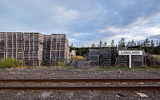
Longlands is a rural community in the Hastings District and Hawke's Bay Region of New Zealand's North Island. The area is on the southern and western outskirts of Hastings city.

Mangateretere is a rural community in the Hastings District and Hawke's Bay Region of New Zealand's North Island. The area is northeast of Hastings city and southwest of Clive.

References

  1. 1 2 3 "ArcGIS Web Application". statsnz.maps.arcgis.com. Retrieved 22 April 2024.
  2. 1 2 "Population estimate tables - NZ.Stat". Statistics New Zealand . Retrieved 25 October 2023.
  3. "Star Telegrams". Thames Star. 16 January 1875. p. 2.
  4. "Karamu Land Sale". Hawke's Bay Herald. 10 February 1891. p. 3.
  5. "Hawke's Bay Notes - Hawke's Bay Land Realises Over £100 Per Acre". Wanganui Herald. 2 April 1919. p. 5.
  6. "Untitled". Poverty Bay Herald. 28 November 1924. p. 4.
  7. "Important Land Sale - Balance of Karamu Estate". Northern Advocate. 21 June 1929. p. 7.
  8. 1 2 "Statistical area 1 dataset for 2018 Census". Statistics New Zealand. March 2020. Karamu (210400). 2018 Census place summary: Karamu