
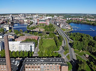
Tampere is a city in the Pirkanmaa region, located in the western part of Finland. Tampere is the most populous inland city in the Nordic countries; it has a population of 238,140 with the urban area holding 334,112 people and the metropolitan area, also known as the Tampere sub-region, holding 385,301 inhabitants in an area of 4,970 km2 (1,920 sq mi). Tampere is the second-largest urban area and third most-populous individual municipality in Finland, after the cities of Helsinki and Espoo and the most populous Finnish city outside the Greater Helsinki area, within which both Helsinki and Espoo are located. Today, Tampere is one of the major urban, economic, and cultural hubs in the whole inland region.

The Battle of Tampere was a 1918 Finnish Civil War battle, fought in Tampere, Finland from 15 March to 6 April between the Whites and the Reds. It is the most famous and the heaviest of all the Finnish Civil War battles. Today it is particularly remembered for its bloody aftermath as the Whites executed hundreds of capitulated Reds and took 11,000 prisoners placed in the Kalevankangas camp.

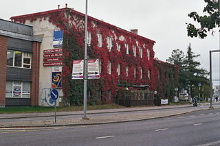
Amuri is a district in the city of Tampere, Finland.

The Tampere Central Square is a public square in the centre of Tampere, Finland, along the main street Hämeenkatu. The Central Square is located on the western shore of Tammerkoski and many important buildings in Tampere are located near it. These include the Tampere City Hall, the Tampere City Central Office Building, the Old Church of Tampere and the Tampere Theatre. The Central Square was called Kauppatori until 1936.

Kyttälä is a district in Tampere, Finland. It was born in the late 1870s as a working-class neighborhood to the eastern outskirts of the town. As Tampere soon expanded, Kyttälä is now a part of the city center between the Tammerkoski river and the railway. Population of Kyttälä is 3,348. Aleksanterinkatu is one of Kyttälä's main streets. The direct connection to the Liisankallio district and from there to Teiskontie and Sammonkatu streets runs along Itsenäisyydenkatu and connection to the Jussinkylä district runs along Tuomiokirkonkatu.
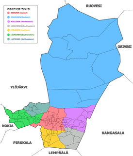
The city of Tampere, the second largest city and urban area of Finland after Helsinki, can be divided into various sorts of subdivisions. The subdivisions include neighbourhoods, districts, major districts and postal code areas. The plethora of different official ways to divide the city is a source of some confusion to the inhabitants, as different kinds of subdivisions often share similar or identical names.

Aleksanterinkatu is a street in the Kyttälä district, in the centre of Tampere, Finland. It is a north–south street, which is one of the cross streets of Hämeenkatu, Tampere's main street. In the south, it intersects the Hatanpää highway at Sori Square and ends in the north at Erkkilänaukee in Jussinkylä, near Tampere Cathedral.

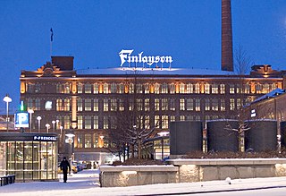
Tampella is a neighbourhood in the northern part of the city center of Tampere, Finland. It consists of the old Tampella factory area, the Armonkallio residential area and the Naistenlahti harbor area. The neighboring parts of the internally heterogeneous district located on the shores of Lake Näsijärvi are Lapinniemi, Lappi, Osmonmäki, Tammela, Jussinkylä, Finlayson and Särkänniemi.
Finlayson is a neighbourhood in the city center of Tampere, Finland, and as the name implies, it consists of the old factory area of Finlayson, as well as Näsinpuisto, the Mustanlahti harbor area and the residential blocks delimited by Hämeenpuisto and Satakunnankatu. To the east, the area borders Tammerkoski. Area attractions include Tallipiha and Finlayson Church. There are also three palace buildings in the district: Finlayson Palace, Näsilinna and Little Palace (Pikkupalatsi). The area starts at Näsilinnankatu and Kuninkaankatu, which extend to Nalkala, and Puuvillatehtaankatu and Näsijärvenkatu, which cross Hämeenpuisto. Neighboring parts of the city are Tammerkoski in the south and Amuri in the west.
Jussinkylä is a neighbourhood in the city center of Tampere, Finland. It is located east of Tammerkoski and borders Satakunnankatu in the south. To the east and northeast, the district is bounded by a railway and to the northwest by Lapintie. The Erkkilä Bridge connects Jussinkylä to Tammela. The most significant landmarks in the area are Tampere Cathedral and Tampere Central Fire Station. Neighboring neighborhoods are Finlayson, Tampella and Kyttälä, from which the latter runs a route along the Tuomiokirkonkatu street.

Särkänniemi is a district of the city centre of Tampere, Finland, located on the shores of Lake Näsijärvi, north of the districts of Amuri and Finlayson. The most famous sights of the district are Näsinneula and Särkänniemi Amusement Park, but in addition to that, the district also houses the Haarla's old paper mill building. The Amuri railway stop has also ceased operations in Särkänniemi. The Särkänniemi district also includes the Siilinkari islet in Lake Näsijärvi. Särkänniemi is bordered on the south by Paasikivenkatu, on the other side of which is the Amuri district, and on the west by the Santalahti district. The district includes the Onkiniemi residential area.

Liisankallio is a district of Tampere, Finland. The district, formerly known as Tammelan vainio, is located east of the Tammela and Tulli districts. To the north is the Petsamo district, to the east are Kaleva and Kalevanrinne, to the south is Kalevanharju. When we often talk about Kaleva, we mean a larger entity formed by Liisankallio, Kaleva and Kalevanrinne.

Osmonmäki is a district in the center of Tampere, Finland. The immediate neighbors of the area are Tammela, Tampella, Lappi and Petsamo. There are apartment buildings in the area, but also hundred-year-old wooden buildings. In 2011, the district had 1,613 inhabitants.
Lappi is a district in Tampere, Finland, near the Lake Näsijärvi and the Kauppi's park area. About 700 people live there. When talking about Lappi, reference is usually made to the Lapinniemi district. The district is home to the Koukkuniemi's nursing home, which is one of the largest nursing homes in Europe. There are also yacht clubs in the area and a spa and apartments in an old factory building were completed for the 1990 housing fair.
Hatanpää is a district in Tampere, Finland, located in the southern part of the city center on the shores of Lake Pyhäjärvi. Hatanpää is actually a peninsula that protrudes towards the lake, leaving the waters of Viinikanlahti Bay to the north and Vihilahti Bay to the south. The area is named after Hatanpää Manor, whose land from Härmälä to Sääksjärvi and Nekala was bought for the city in 1913. Administratively, the area has belonged to the city since 1920. In 2014, the population of the area was measured as 2,686 inhabitants.
Ratina is a district in the center of Tampere, Finland, on the east side of Tammerkoski. The Ratina Stadium, Tampere Bus Station and Tampere's largest shopping mall, the Ratina shopping centre, are located in the district, among others. To the north of Ratina is also the Koskikeskus shopping centre. The district consists of a peninsula called Ratinanniemi, which is surrounded on three sides by Ratinansuvanto and Viinikanlahti. Between Ratinanniemi and the Laukontori square is a pedestrian bridge called Laukonsilta, which significantly shortens travel time to the city center. The Tampere highway has good connections to the Helsinki-Tampere motorway and along it to the Tampere Ring Road, and via the Ratinansilta bridge and the Hämeenpuisto park to Highway 12. Ratinanranta is the southern part of the Tampere highway from Ratina, which used to be a recreation ground and factory area. Its new construction into a dense apartment building area of 1,000 inhabitants began in 2008, and the latest residential buildings east of the Voimakatu street are expected to be completed in 2013.

Pyynikinrinne is a district of Tampere, Finland. It is located west of the city center. Pyynikinrinne is bordered on the south by the Pyynikki Esker nature reserve, on the north by Pirkankatu and on the east by Mariankatu. The western boundary of the district is the former border between Tampere and Pohjois-Pirkkala municipalities. The neighboring parts of the city are Pyynikki, Ylä-Pispala, Amuri, partly Särkänniemi and Kaakinmaa.

Kaakinmaa is a district in Tampere, Finland, located in the city center. It includes the area south of Pyynikki Church Park between the Hämeenpuisto park and the Mariankatu street. To the south, the area extends to Eteläpuisto on the shores of Lake Pyhäjärvi. The neighboring parts of the city are Nalkala in the east, Amuri in the north and Pyynikki and Pyynikinrinne in the west. Sometimes Kaakinmaa is incorrectly considered to belong to Pyynikki and Pyynikinrinne; however, Kaakinmaa has its own district.

Satakunnankatu is an east–west, busy street in the center of Tampere, Finland, which is one of the city's main streets. It starts from the vicinity of Tampere Cathedral on the east side of Tammerkoski, where it separates the Jussinkylä and Kyttälä Districts. The street crosses the rapids along the Satakunta Bridge (Satakunnansilta) and runs on the west side between Finlayson and the Hämeenpuisto park. From there it continues through the Amuri area to the Pirkankatu street.
Kalevanharju is a district of Tampere, Finland. It is bordered on the north by Liisankallio, on the northeast by Kaleva, on the east by Kalevanrinne, on the south by Hatanpää, on the west by Ratina and on the northwest by Tulli. The Central Campus of the Tampere University, the Kalevankangas Cemetery and the Tampere Adult Education Center are located in Kalevanharju.


