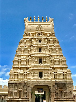
Srirangapatna is a town and headquarters of one of the seven Taluks of Mandya district, in the Indian State of Karnataka. It gets its name from the Ranganthaswamy temple consecrated around 984 CE. Later, under the British rule, the city was renamed to Seringapatnam. Located near the city of Mandya, it is of religious, cultural and historic importance.
Mandya district is an administrative district of Karnataka, India. The district is bordered on the south by Mysore and Chamarajangar districts, on the west by Hassan district, on the north by Tumkur district and on the east by Ramanagara district. The district Mandya was carved out of larger Mysore district in the year 1939.
Arakere is a village in the southern state of Karnataka, India. It is located in the Shrirangapattana taluk of Mandya district in Karnataka.
Belagola , sometimes referred to as Mandya Belagola to distinguish it from Shravana Belagola, is a village in the southern state of Karnataka, India. It is located about 15 kilometers north-northwest of Mysuru city in the Shrirangapattana taluk of Mandya district in Karnataka. It is around 7 km from famous K.R.S. dam.

Belluru is a village in the southern state of Karnataka, India. It is located in the Nagamangala taluk of Mandya district in Karnataka.
Thumbakere is a village in the southern state of Karnataka, India. It is located in the Mandya taluk of Mandya district in Karnataka.
Budanur is a village in the southern state of Karnataka, India. It is located in the Mandya taluk of Mandya district in Karnataka.
Doddarasinakere is a village in the southern state of Karnataka, India. It is located in the Maddur taluk of Mandya district in Karnataka. Its location code number as per 2011 census is 614621.
Gummanahalli is a village in the southern state of Karnataka, India. It is located in the Pandavapura taluk of Mandya district in Karnataka.

Halaguru or Halagur is a town in the southern state of Karnataka, India.
Kalkuni is a village in the southern state of Karnataka, India. It is located in the Malavalli taluk of Mandya district in Karnataka.
Keelara is a village in the southern state of Karnataka, India. It is located in the Mandya taluk of Mandya district. The village is around 10 km from Mandya city and 96 km from the capital city of Karnataka via NH-275.
Kennalu is a village in the southern state of Karnataka, India. It is located in the Pandavapura taluk of Mandya district in Karnataka. 400 years old Shiva temple is an attraction in the village. This temple is renovated by Mr. Veerendra Hegde of Dharmasthala.
Keregodu is a village in the southern state of Karnataka, India. It is located in the Mandya taluk of Mandya district in Karnataka. Panchalingeshwara temple is a noted landmark here.
Kirugavalu is a village in the southern state of Karnataka, India. Kirugavalu is located in the Malavalli taluk of Mandya district in Karnataka.
Mellahalli is a village in the southern state of Karnataka, India. It is located in the Maddur taluk of Mandya district in Karnataka.
Palahalli is a village in the southern state of Karnataka, India. It is located in the Shrirangapattana taluk of Mandya district in Karnataka. It is known for having the first sugar factory being built when it was a British colony.
Santhekasalagere is a village in the southern state of Karnataka, India. It is located in the Mandya taluk of Mandya district in Karnataka.
Adihalli (Krishnarajpet) is a village in the southern state of Karnataka, India. It is located in the Krishnarajpet taluk of Mandya district in Karnataka.

Shrirangapattana Assembly constituency is one of the 224 Legislative Assembly constituencies of Karnataka state in India.
