Belakavadi

Last updated

Belakavadi
Village
Belakavadi.jpg
Nickname: 
Belakodi
India Karnataka location map.svg
Red pog.svg
Belakavadi
Location in Karnataka, India
India location map.svg
Red pog.svg
Belakavadi
Belakavadi (India)
Coordinates: 12°15′18″N77°7′21″E / 12.25500°N 77.12250°E / 12.25500; 77.12250
CountryFlag of India.svg  India
State ..Karnataka Flag(INDIA).png Karnataka
District Mandya
Taluk Malavalli
Government
  Type Village Panchayat
  BodyBelakavadi Gram Panchayat
Population
 (2001)
  Total9,851
Languages
  Official Kannada
Time zone UTC+5:30 (IST)
PIN
571417 [1]
Vehicle registration KA-11

Belakavadi or Belakawadi is a village in the southern state of Karnataka, India. [2] [3] It is located in the Malavalli taluk of Mandya district in Karnataka. As per the records of Hoysala rulers Belakavadi was one of the central places of administrative divisions. [4] Temples include Shanbhulingeshwara Temple, [5] Kashi Vishwanatheshwara Temple and maramma temple, Mayamma temple , Mandalakamma temple etc..

Contents

Demographics

The office of the Gram Panchayat, Belakavadi Losangra-abiyana-malavalli-taluck-belakavadi-sakthikendra.jpg
The office of the Gram Panchayat, Belakavadi

As of 2001 India census, Belakavadi had a population of 9851 with 4888 males and 4963 females. [2] Majority of the population belong to Hinduism.

History

Belakavadi is on the left bank of the river Kaveri situated 20 km southwest of the taluk centre Malavalli. Plenty of red, black, black red and coloured pottery as well as Rousette coated potteries of the Megalithic age were discovered in a site on the banks of the river. On some of them are traces of decorations. In a ruined pit, animal bones were found. The 1945-46 report of the department of Archaeology refers to it, probably as a mud burial. All the six inscriptions reported from this place are of the Vijayanagar period and registers the grant given to the Shambhulinga temple. The Ishwara temple on the river bank, is a structure of about 15th century and the Veerabhadra temple in the centre street of the village is of about 14th century. There are other temples such as Kattebasappa, Upparige Basaveshwara and Mandalakamma, It also has more than seven hero stones and several Masti stones. [6]

Notable people

Transport

The village is well connected by roads. KSRTC (Karnataka State Road Transport Corporation) ply buses from Bengaluru, Mysuru, Malavalli, Kollegala and T.Narasipura.

See also

Related Research Articles

<span class="mw-page-title-main">Mandya district</span> District of Karnataka in India

Mandya district is an administrative district of Karnataka, India. The district is bordered on the south by Mysore and Chamarajangar districts, on the west by Hassan district, on the north by Tumkur district and on the east by Ramanagara district. The district Mandya was carved out of larger Mysore district in the year 1939.

<span class="mw-page-title-main">Shivanasamudra Falls</span> Waterfall in Karnataka, India

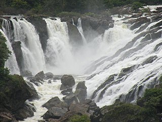
Shivanasamudra Falls is a cluster of waterfalls on the borders of Malavalli, Mandya and Kollegala, Chamarajanagara, in Karnataka, India, situated along the river Kaveri. The falls form the contour between the districts of Chamarajanagara and Mandya. The Bharachukki Falls in Kollegala, with a height of 69 metres, and the Gaganachukki Falls in Malavalli, with a height of 90 metres, collectively form the Shivanasamudra Falls.

<span class="mw-page-title-main">Malavalli</span> Town in Karnataka, India

Malavalli is a town and a taluka in Mandya district in the Indian state of Karnataka. Malavalli town in history is quoted dates back to 27 March 1799 - Fourth Anglo Mysore War. Battle of Malavalli was fought between Tippu Sultan's Mysore Army against the British East India Company led by Arthur Wellesley. The men from the town fought fiercely and laid down their lives. The postal code of Malavalli is 571430.

<span class="mw-page-title-main">Shimsha</span> Tributary of Kaveri river

Shimsha is a river that flows in the state of Karnataka, India. It is one of the tributaries of the river Kaveri, which is one of the major rivers of South India. The river originates in the southern part of the Devarayanadurga hill in the Tumkur district of Karnataka and flows for about 221 km (137 mi). before joining the river Kaveri.

<span class="mw-page-title-main">Arakere, Shrirangapattana</span> Village in Karnataka, India

Arakere is a village in the southern state of Karnataka, India. It is located in the Shrirangapattana taluk of Mandya district in Karnataka.

<span class="mw-page-title-main">Belagola</span> Village in Karnataka, India

Belagola , sometimes referred to as Mandya Belagola to distinguish it from Shravana Belagola, is a village in the southern state of Karnataka, India. It is located about 15 kilometers north-northwest of Mysuru city in the Shrirangapattana taluk of Mandya district in Karnataka. It is around 7 km from famous K.R.S. dam.

<span class="mw-page-title-main">Belluru Cross</span> Village in Karnataka, India

Belluru is a village in the southern state of Karnataka, India. It is located in the Nagamangala taluk of Mandya district in Karnataka.

Budanur is a village in the southern state of Karnataka, India. It is located in the Mandya taluk of Mandya district in Karnataka.

<span class="mw-page-title-main">Halaguru</span> Town in Karnataka, India

Halaguru or Halagur is a town in the southern state of Karnataka, India.

Kalkuni is a village in the southern state of Karnataka, India. It is located in the Malavalli taluk of Mandya district in Karnataka.

Kennalu is a village in the southern state of Karnataka, India. It is located in the Pandavapura taluk of Mandya district in Karnataka. 400 years old Shiva temple is an attraction in the village. This temple is renovated by Mr. Veerendra Hegde of Dharmasthala.

Keregodu is a village in the southern state of Karnataka, India. It is located in the Mandya taluk of Mandya district in Karnataka. Panchalingeshwara temple is a noted landmark here.

Kirugavalu is a village in the southern state of Karnataka, India. Kirugavalu is located in the Malavalli taluk of Mandya district in Karnataka.

Mellahalli is a village in the southern state of Karnataka, India. It is located in the Maddur taluk of Mandya district in Karnataka.

<span class="mw-page-title-main">Abalur</span> Village in Karnataka, India

Abalur is a village in the southern state of Karnataka, India. It is located in the Hirekerur taluk of Haveri district in Karnataka. Abalur is the birthplace of Sarvajña, considered most prolific poet in Kannada literature and famous for his three-line poems called Thripadigalu.

Agasanapura is a village in the southern state of Karnataka, India. It is located in the Malavalli taluk of Mandya district in Karnataka.

<span class="mw-page-title-main">Aghalaya</span> Village in Karnataka, India

Aghalaya is a village in the southern state of Karnataka, India. It is located in the Krishnarajpet taluk of Mandya district in Karnataka. Aghalaya village is famous for the ancient Malleswara temple of lord Shiva.

<span class="mw-page-title-main">Akkihebbal</span> Hobli in Karnataka, India

Akkihebbalu is a Hobli in the southern state of Karnataka, India. It is located in the Krishnarajpet taluk of Mandya district in Karnataka.

<span class="mw-page-title-main">Alada Halli, Malavalli</span> Village in Karnataka, India

Alada Halli is a village in the southern state of Karnataka, India. It is located in the Malavalli taluk of Mandya district in Karnataka.

Patrame is a small, rural panchayat village on the left (east) bank of the Netravati River in Karnataka, India. Administratively, it is under Belthangady taluk, Dakshina Kannada district, Karnataka. Patrame is the only village in its gram panchayat. The village of Patrame is 26 km from its taluk headquarters Belthangady, and 8 km by road from Dharmasthala.

References

  1. "Belakavadi Pincode, photos and website". IndiaStudyChannel.com. Archived from the original on 4 September 2018. Retrieved 21 December 2011.
  2. 1 2 Village code= 2431600 "Census of India : Villages with population 5000 & above". Registrar General & Census Commissioner, India. Archived from the original on 8 December 2008. Retrieved 18 December 2008.
  3. "Yahoomaps India". Archived from the original on 18 December 2008. Retrieved 18 December 2008. Belakavadi, Mandya, Karnataka
  4. "Archived copy" (PDF). Archived from the original (PDF) on 8 October 2011. Retrieved 1 January 2011.{{cite web}}: CS1 maint: archived copy as title (link) , pg 2
  5. http://www.shaivam.org/siddhanta/spka-mandya-temples.htm , Malavalli Taluk Shiva Temples
  6. "Archived copy" (PDF). Archived from the original (PDF) on 8 October 2011. Retrieved 1 January 2011.{{cite web}}: CS1 maint: archived copy as title (link) , pg 17
  7. "Archived copy" (PDF). Archived from the original (PDF) on 26 April 2012. Retrieved 1 January 2011.{{cite web}}: CS1 maint: archived copy as title (link) ,pg 2