
Mandya is a city in the state of Karnataka. It is the headquarter of Mandya district, Sugar factories contribute to the major economic output. It is also called Sugar City because sugarcane is a major crop grown here. The district offices are located here. The city has been divided into 35 wards of the Mandya City Municipal Council.

Mysore division, officially Mysuru division, is an administrative division in the southern Indian state of Karnataka. It is one of four administrative divisions in Karnataka, the others being Bangalore division, Belagavi division, and Kalaburagi division. Mysore division comprises eight districts of Karnataka, namely, Chamarajanagar, Chikmagalur, Dakshina Kannada, Hassan, Kodagu, Mandya, Mysore and Udupi district. The city of Mysore is the administrative headquarters of the division. Mysore division covers parts of historical Old Mysore region and southern part of Coastal Karnataka.The total area of the division is 43,503 sq.km. The total population as of 2011 census is 12,563,598.
Mandya district is an administrative district of Karnataka, India. The district is bordered on the south by Mysore and Chamarajangar districts, on the west by Hassan district, on the north by Tumkur district and on the east by Ramanagara district. The district Mandya was carved out of larger Mysore district in the year 1939.

Malavalli is a town and a taluka in Mandya district in the Indian state of Karnataka. Malavalli town in history is quoted dates back to 27 March 1799 - Fourth Anglo Mysore War. Battle of Malavalli was fought between Tippu Sultan's Mysore Army against the British East India Company led by Arthur Wellesley. The men from the town fought fiercely and laid down their lives.

Pandavapura is a Municipality Town in Mandya district in the Indian state of Karnataka.
Arakere is a village in the southern state of Karnataka, India. It is located in the Shrirangapattana taluk of Mandya district in Karnataka.
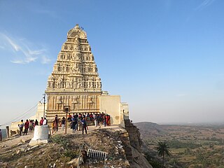
Belakavadi or Belakawadi is a village in the southern state of Karnataka, India. It is located in the Malavalli taluk of Mandya district in Karnataka. As per the records of Hoysala rulers Belakavadi was one of the central places of administrative divisions. Temples include Shanbhulingeshwara Temple, Kashi Vishwanatheshwara Temple and maramma temple, Mayamma temple, Mandalakamma temple etc..

Belluru is a village in the southern state of Karnataka, India. It is located in the Nagamangala taluk of Mandya district in Karnataka.
Budanur is a village in the southern state of Karnataka, India. It is located in the Mandya taluk of Mandya district in Karnataka.

Halaguru or Halagur is a town in the southern state of Karnataka, India.
Kalkuni is a village in the southern state of Karnataka, India. It is located in the Malavalli taluk of Mandya district in Karnataka.
Keelara is a village in the southern state of Karnataka, India. It is located in the Mandya taluk of Mandya district. The village is around 10 km from Mandya city and 96 km from the capital city of Karnataka via NH-275.
Kennalu is a village in the southern state of Karnataka, India. It is located in the Pandavapura taluk of Mandya district in Karnataka. 400 years old Shiva temple is an attraction in the village. This temple is renovated by Mr. Veerendra Hegde of Dharmasthala.
Keregodu is a village in the southern state of Karnataka, India. It is located in the Mandya taluk of Mandya district in Karnataka. Panchalingeshwara temple is a noted landmark here.
Mellahalli is a village in the southern state of Karnataka, India. It is located in the Maddur taluk of Mandya district in Karnataka.
Agasanapura is a village in the southern state of Karnataka, India. It is located in the Malavalli taluk of Mandya district in Karnataka.

Akkihebbalu is a Hobli in the southern state of Karnataka, India. It is located in the Krishnarajpet taluk of Mandya district in Karnataka.

Alada Halli is a village in the southern state of Karnataka, India. It is located in the Malavalli taluk of Mandya district in Karnataka.

Yachenahalli is a panchayat town in Mysore district in the state of Karnataka, India. It is located 35 km from Mysore and 17 km from Mandya. The nearest city is Bannur with 10 km distance.

Narayanapura is a small village in Mandya district of Karnataka state, India. Narayanapura is located 18.7 km (11.6 mi) north of Pandavapura town near Mysore city.
