Halaguru

Last updated

Halaguru
Halaguru.jpg
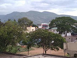
Aerial view towards Basavana Betta.
Nickname: 
Panchalgere
India Karnataka location map.svg
Red pog.svg
Halaguru
Location in Karnataka, India
Coordinates: 12°15′N77°08′E / 12.25°N 77.13°E / 12.25; 77.13
CountryFlag of India.svg  India
State Flag of India.svg  Karnataka
District Mandya district
Established1600
Founded byPanchalas
Talukas Malavalli
Government
  Type Gram panchayat
Area
  Total5.23 km2 (2.02 sq mi)
Elevation
626 m (2,054 ft)
Population
 (2011)
  Total10,176 [1]
Demonym(s) Halagurian,Halagurinavaru
Languages
  Official Kannada
Time zone UTC+5:30 (IST)
PIN
571421
Vehicle registration KA-11
Nearest city Malavalli

Halaguru or Halagur is a town in the southern state of Karnataka, India.

Contents

Location

Main road in Halaguru MainRoad halaguru.jpg
Main road in Halaguru

Halaguru is situated at NH 948 (previously NH 209) and state highway KA SH 94. It is one of the oldest towns in Mandya district. It is 82 km from Bangalore the capital city of Karnataka, 60 km from Mysore, 50 km from Mandya, 41 km from Ramanagara, 10 km from Sathanur, 27 km from Kanakapura, 29 km from Channapatna and 90 km from Chamarajanagar

History

Halaguru had a history of seven great blacksmiths who had ruled the town.[ citation needed ]

Around 1000 people belong to the Vishwakarma community and they are living in the same street, Achar Street. Most of them are goldsmiths. This is the only place in Karnataka where Vishwakarma people found majority. [2] [3]

Geography

Halaguru is located in the Malavalli taluk of Mandya district in Karnataka. Main river is the Shimsa river one of the tribute of Kaveri. River Kaveri is located 15 km from the town at Bheemeshwari camp. It is one of the famous tourist attractions, and also near by other tourist places are Muthathi, Kokrebellur, Mekedaatu, Benki falls or Ganalu falls and Shivanasamudra Falls.

Benki falls GANNALfalls.jpg
Benki falls
Hydro electric channel at Ganal village Channel 1.jpg
Hydro electric channel at Ganal village

Demographics

As of the 2011 India census, Halaguru had a population of 10,176 comprising 5,107 males and 5,069 females giving a ratio of 993, higher than the Karnataka state average of 973. There were 1,008 children aged 0-6 i.e. 9.91 % of the town's population. The literacy rate was 79.57 % (males 85.58 % and females 73.57 %. higher than the state average of 75.36 %. [4]

Halaguru is administrated by a sarpanch (head of village) who is the village's elected representative.

Education

Halaguru has both private and government institutes, including:

Related Research Articles

<span class="mw-page-title-main">Mandya</span> City in Karnataka, India

Mandya is a city in the state of Karnataka. It is the headquarter of Mandya district and is located 45 kilometres (28 mi) from Mysore and 100 kilometres (62 mi) from Bangalore.

<span class="mw-page-title-main">Kalpetta</span> Town,City in Kerala, India

Kalpetta is a major City,Town and municipality in the Wayanad district, state of Kerala, India. Kalpetta is the headquarters, Capital of Wayanad district, as well as the headquarters of Vythiri taluk. It is a bustling city, town surrounded by dense coffee and tea plantations and mountains. It lies on the Kozhikode-Mysore National Highway NH 766 at an altitude of about 780 m above sea level. Kalpetta is 72 km from Kozhikode and 140 km from Mysore.

<span class="mw-page-title-main">Mysore division</span> Administrative division in Karnataka, India

Mysore division, officially Mysuru division, is an administrative division in the southern Indian state of Karnataka. It is one of four administrative divisions in Karnataka, the others being Bangalore division, Belagavi division, and Kalaburagi division. Mysore division comprises eight districts of Karnataka, namely, Chamarajanagar, Chikmagalur, Dakshina Kannada, Hassan, Kodagu, Mandya, Mysore and Udupi district. The city of Mysore is the administrative headquarters of the division. Mysore division covers parts of historical Old Mysore region and southern part of Coastal Karnataka.The total area of the division is 43,503 sq.km. The total population as of 2011 census is 12,563,598.

<span class="mw-page-title-main">Hassan district</span> District of Karnataka in India

Hassan is one of the 31 districts of Karnataka, India. The district headquarter is Hassan. It was carved out from Mysore district in the year 1866, during the Commissioner's Rule of Mysore (1831-81).

<span class="mw-page-title-main">Mandya district</span> District of Karnataka in India

Mandya district is an administrative district of Karnataka, India. The district is bordered on the south by Mysore and Chamarajangar districts, on the west by Hassan district, on the north by Tumkur district and on the east by Ramanagara district. The district Mandya was carved out of larger Mysore district in the year 1939.

<span class="mw-page-title-main">Shivanasamudra Falls</span> Waterfall in Karnataka, India

Shivanasamudra Falls is a cluster of waterfalls on the borders of Malavalli, Mandya and Kollegala, Chamarajanagara, in Karnataka, India, situated along the river Kaveri. The falls form the contour between the districts of Chamarajanagara and Mandya. The Bharachukki Falls in Kollegala, with a height of 69 metres, and the Gaganachukki Falls in Malavalli, with a height of 90 metres, collectively form the Shivanasamudra Falls.

The town of Virajpet also spelled as Virajapete is the second town of the district of Kodagu (Coorg), in Karnataka. It is the main town of the Virajpet taluka, south of the district, in the Kerala-Karnataka border. The name is an abbreviation of Virarajendrapete after the former ruler of Kodagu, Virarajendra.

<span class="mw-page-title-main">Somwarpet</span> Town in Karnataka, India

Somwarpet is a panchayat town in Kodagu district in the Indian state of Karnataka. It is the main town of the Somwarpet taluk, in the north-east of the district. 2nd highest Administrative town in Karnataka in terms of elevation. The main crops grown in the area are coffee and spice crops such as cardamom, peppers, oranges, ginger and vegetables.

<span class="mw-page-title-main">Holenarasipura</span> Town in Karnataka, India

Holenarasipura is a town and taluk in Hassan district of Karnataka. The town is situated on the banks of the Hemavati, one of the tributaries of the Kaveri.

<span class="mw-page-title-main">Kanakapura</span> City in Karnataka, India

Kanakapura is a city in the Ramanagara district of Karnataka on the banks of the Arkavathi river and the administrative center of the taluk of the same name. Kanakapura is largest cocoon silk producer in India. River Cauvery flows around 21 km in Kanakapura Taluk.Previously belonged to Bangalore Rural District. It was formerly the largest constituency in the country. (1,553 km2 [600 sq mi]). It is located among the lush green forests of the state of Karnataka. The town is a tourism hotspot and an often visited tourist favorite in the entire state of Karnataka, as it has something for everyone ranging from avid trekkers to history buffs and wildlife enthusiasts. The forest area in this taluk is very wide and about half of the Bannerghatta National Park is located in our Kanakapura area. Kodihalli wildlife range and harohalli wildlife range its division. The Kaveri Wildlife Sanctuary consists of two main zones namely the Sangam Wildlife range, the Muggur Wildlife range

Arkalgud, also known as Arakalagudu is a panchayat town and is one among the eight taluks of Hassan district in the state of Karnataka, India. It is situated 30 km from Hassan, 181 km from Mangalore and 195 km from Bangalore. The river Hemavati forms the entire northern boundary of the Taluk; river Kaveri runs through a portion of the south. It is well connected by road to many towns and cities of Karnataka. Hassan Junction railway station is the nearest major railway station and Kannur International Airport is the nearest airport at 150 kilometres.

Krishnarajasagara is a town in Mandya district in the Indian state of Karnataka.

<span class="mw-page-title-main">Maddur, Mandya</span> Town in Karnataka, India

Maddur is a town in Mandya district in the Indian state of Karnataka. It lies on the banks of the river Shimsha. It is 82 kilometers from the state capital Bangalore and 60 kilometers from Mysore. Derived from Maddu a term referring to chemicals used for explosives.

<span class="mw-page-title-main">Malavalli</span> Town in Karnataka, India

Malavalli is a town and a taluka in Mandya district in the Indian state of Karnataka. Malavalli town in history is quoted dates back to 27 March 1799 - Fourth Anglo Mysore War. Battle of Malavalli was fought between Tippu Sultan's Mysore Army against the British East India Company led by Arthur Wellesley. The men from the town fought fiercely and laid down their lives.

<span class="mw-page-title-main">Nagamangala</span> Town in Karnataka, India

Nagamangala is a PuraSabhe and a taluk in Mandya district, in the Indian state of Karnataka.

<span class="mw-page-title-main">Pandavapura</span> Town in Karnataka, India

Pandavapura is a Municipality Town in Mandya district in the Indian state of Karnataka.

<span class="mw-page-title-main">Thirumakudalu Narasipura</span> Town in Karnataka, India

Tirumakudalu Narasipura the temple city of Karnataka, commonly known as T. Narasipura or T.N. Pura, is a town in Mysore district in the Indian state of Karnataka. The first name refers to the land at the confluence, (trimakuta in Sanskrit at the confluence of the Kaveri, Kabini and Spatika Sarovara.

<span class="mw-page-title-main">Shimsha</span> Tributary of Kaveri river

Shimsha is a river that flows in the state of Karnataka, India. It is one of the tributaries of the river Kaveri, which is one of the major rivers of South India. The river originates in the southern part of the Devarayanadurga hill in the Tumkur district of Karnataka and flows for about 221 km (137 mi). before joining the river Kaveri.

Keelara is a village in the southern state of Karnataka, India. It is located in the Mandya taluk of Mandya district. The village is around 10 km from Mandya city and 96 km from the capital city of Karnataka via NH-275.

<span class="mw-page-title-main">Yachenahalli</span> Village in Karnataka, India

Yachenahalli is a panchayat town in Mysore district in the state of Karnataka, India. It is located 35 km from Mysore and 17 km from Mandya. The nearest city is Bannur with 10 km distance.

References

  1. "Census Data Handbook 2011" (PDF). Retrieved 26 November 2023.
  2. Registrar General & Census Commissioner, India. "Census of India : Villages with population 5000 & above" . Retrieved 18 December 2008.
  3. "Yahoomaps India :" . Retrieved 18 December 2008. Halaguru, Mandya, Karnataka
  4. "Halaguru Population - Mandya, Karnataka". census2011.co.in. Retrieved 20 December 2017.