The Golden Gate is a strait on the west coast of North America that connects San Francisco Bay to the Pacific Ocean. It is defined by the headlands of the San Francisco Peninsula and the Marin Peninsula, and, since 1937, has been spanned by the Golden Gate Bridge. The entire shoreline and adjacent waters throughout the strait are managed by the Golden Gate National Recreation Area.

Angel Island is an island in San Francisco Bay. The entire island is included within Angel Island State Park, administered by California State Parks. The island, a California Historical Landmark, has been used by humans for a variety of purposes, including seasonal hunting and gathering by indigenous peoples, water and timber supply for European ships, ranching by Mexicans, United States military installations, a United States Public Health Service Quarantine Station, and a U.S. Bureau of Immigration inspection and detention facility. The Angel Island Immigration Station, on the northeast corner of the island, which has been designated a National Historic Landmark, was where officials detained, inspected, and examined approximately one million immigrants, who primarily came from Asia. Under the Chinese Exclusion Act of 1882, the first United States law to restrict a group of immigrants based on their race, nationality, and class, all arriving Chinese immigrants were to be examined by immigration or customs agents.

Grandview Park, also referred to as Turtle Hill by local residents, is a small, elevated park in the Sunset District, San Francisco, California. It is surrounded by 14th and 15th Avenues, as well as Noriega Street.

Mount Tamalpais, known locally as Mount Tam, is a peak in Marin County, California, United States, often considered symbolic of Marin County. Much of Mount Tamalpais is protected within public lands such as Mount Tamalpais State Park, the Marin Municipal Water District watershed, and National Park Service land, such as Muir Woods.

The Marin Headlands are a hilly peninsula at the southernmost end of Marin County, California, United States, located just north of San Francisco across the Golden Gate Bridge, which connects the two counties and peninsulas. The entire area is part of the Golden Gate National Recreation Area. The Headlands are famous for their views of the Bay Area, especially of the Golden Gate Bridge.

New Brighton State Beach is a 95 acres (38 ha) beach park on Monterey Bay in Santa Cruz County, California, consisting of a beach and campgrounds. The park is located east of Santa Cruz in Capitola, on Park Avenue off of Highway 1. The park is adjacent to Seacliff State Beach, which is known for its fishing pier and sunk concrete freighter, The Palo Alto. The beach overlooks Soquel Cove and Monterey Bay.

The Golden Gate National Recreation Area (GGNRA) is a U.S. National Recreation Area protecting 82,116 acres (33,231 ha) of ecologically and historically significant landscapes surrounding the San Francisco Bay Area. Much of the park is land formerly used by the United States Army. GGNRA is managed by the National Park Service and is the second-most visited unit of the National Park system in the United States, with more than 15.6 million visitors in 2022. It is also one of the largest urban parks in the world, with a size two-and-a-half times that of the consolidated city and county of San Francisco.

Montaña de Oro is a state park in Central Coastal California, six miles southwest of Morro Bay and two miles south of Los Osos.
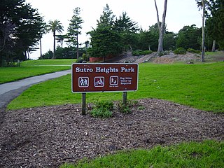
Sutro Heights Park is an historic public park in the Outer Richmond District of western San Francisco, California. It is within the Golden Gate National Recreation Area and the Sutro Historic District.

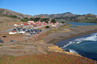
Fort Baker is one of the components of California's Golden Gate National Recreation Area. The Fort, which borders the City of Sausalito in Marin County and is connected to San Francisco by the Golden Gate Bridge, served as an Army post until the mid-1990s, when the headquarters of the 91st Division moved to Parks Reserve Forces Training Area. It is located opposite Fort Point at the entrance to the San Francisco Bay.

Plumper Cove Marine Provincial Park is a provincial park in British Columbia, Canada. The park is located on Keats Island in Howe Sound, northwest of Vancouver, British Columbia.

Rodeo Beach is a beach in the Golden Gate National Recreation Area located in Marin County, California, United States, two miles north of the Golden Gate Bridge. It is characterized by a spit of around 50 meters width at the mouth of a long embayment, known as Rodeo Lagoon; for much of the year the lagoon is cut off from the ocean, making the beach spit a baymouth bar. Part of the beach is sheltered by cliffs. Rodeo Beach is known for its dark, pebbly sand, its uses for surfing and sunbathing, and its locale as a place for viewing, but not collecting, semi-precious stones. This beach is unique among California beaches in that it is largely made up of coarse, pebbly chert grains, both red and green in color. Its mineral composition sets it apart from every other beach in the state. Surfing is possible throughout the year and at all tidal stages, but is best in summer—although there is a risk of shark attacks. Due to the North bar offshore of this beach it results in big waves in the winter months with the big swells that come in. Strong currents make swimming dangerous.

Mori Point is a 110-acre (0.4 km2) park located in Pacifica, California, that is part of the Golden Gate National Recreation Area (GGNRA). Mori Point itself is a bluff next to the Pacific Ocean that provides scenic views of the peninsula coastline. In addition to the bluff and ridge, Mori Point contains a few small ponds and wetlands. Trails, many newly built, connect the ridgeline to the entrances to the park and to Sharp Park beach. A portion of the California Coastal Trail will run through Mori Point.

Fort Funston is a former harbor defense installation located in the southwestern corner of San Francisco. Formerly known as the Lake Merced Military Reservation, the fort is now a protected area within the Golden Gate National Recreation Area (GGNRA) and is used widely as an off-leash dog park. It was named in honor of Frederick N. Funston (1865–1917), a Major General in the United States Army with strong connections to San Francisco, and included several artillery batteries. The fort is located on Skyline Boulevard at John Muir Drive, west of Lake Merced.

The Sutro Historic District is a National Park Service historic district in the Lands End area of the Outer Richmond District in western San Francisco, California. It is within the Golden Gate National Recreation Area, since being acquired by the National Park Service in 1977.

China Beach is a small cove in San Francisco's Sea Cliff neighborhood. It lies between Baker Beach and Lands End and is part of the Golden Gate National Recreation Area. It was once used as a campsite for Chinese fishermen who anchored their boats in the cove. There is a monument to them at the trailhead by the parking area by Sea Cliff Avenue.
Tamalpais Valley is an unincorporated community in Marin County, California.

The Tennessee Valley is a small, undeveloped part of Marin County, near Mill Valley. Historically home to ranches and threatened with the development of a new city, the valley was incorporated into the Golden Gate National Recreation Area in 1972, with additional sections added to the park in 1974. The park contains horse stables, a native-plant nursery, and numerous trails for hiking, biking, and horse riding, including a 1.7-mile, handicap-accessible trail that leads to Tennessee Cove and its beach.
Fort Cronkhite is one of the components of California's Golden Gate National Recreation Area. Today part of the National Park Service, Fort Cronkhite is a former US Army post that served as part of the coastal artillery defenses of the San Francisco Bay Area during World War II. The soldiers at Cronkhite manned gun batteries, radar sites, and other fortifications on the high ridges overlooking the fort.
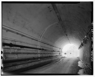
The Baker–Barry Tunnel connects the former military bases Fort Barry and Fort Baker in the Marin Headlands of Marin County, California. The bases are now part of the Golden Gate National Recreation Area. The tunnel is also known as the Bunker Road Tunnel for the road that runs through it, or as the Five-Minute Tunnel because it is only wide enough to accommodate a single reversible lane, opened to traffic at either end for five minute intervals.