Kirkoswald
| |
---|---|
The Main Street | |
Location within South Ayrshire | |
Population | 194 |
OS grid reference | NS240075 |
Council area | |
Lieutenancy area | |
Country | Scotland |
Sovereign state | United Kingdom |
Post town | MAYBOLE |
Postcode district | KA19 |
Dialling code | 01655 |
Police | Scotland |
Fire | Scottish |
Ambulance | Scottish |
UK Parliament | |
Scottish Parliament | |
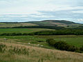
Kirkoswald (Scots : Kirkossald) [1] is a village and parish in the Carrick district of Ayrshire, Scotland, 1+3⁄4 miles (3 kilometres) from the coast and four miles (six kilometres) southwest of Maybole. It takes its name from its kirk (church), dedicated to Oswald of Northumbria, who is said to have won a battle here in the 7th century. The old church, which was built in 1244 and houses the baptismal font of Robert the Bruce, is now a ruin in the grounds of the modern church, which was built in 1777 to a design by Robert Adam. Kirkoswald is also noted for its connection with Robert Burns, whose maternal ancestors, the Brouns, were from the village. Burns also attended school here, and would later base the characters Tam o' Shanter, Kirkton Jean and souter Johnnie on village locals Douglas Graham, Jean Aird and John Davidson, the shoemaker.
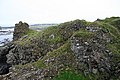
Kirkoswald village had a population of 194 in 1991. Kirkoswald parish is 23.3 square miles (60 square kilometres) in area, and also contains the coastal village of Maidens. Landmarks include Turnberry Castle, the ancient seat of the Earls of Carrick, Culzean Castle, Thomaston Castle and Crossraguel Abbey.
Rev Robert Hunter Arbuckle was minister of the Free Church from 1860 and 1897. [2]
Ayrshire is a historic county and registration county in south-west Scotland, located on the shores of the Firth of Clyde. Its principal towns include Ayr, Kilmarnock and Irvine and it borders the counties of Renfrewshire and Lanarkshire to the north-east, Dumfriesshire to the south-east, and Kirkcudbrightshire and Wigtownshire to the south. Like many other counties of Scotland it currently has no administrative function, instead being sub-divided into the council areas of East Ayrshire, North Ayrshire and South Ayrshire. It has a population of approximately 366,800.
South Ayrshire is one of thirty-two council areas of Scotland, covering the southern part of Ayrshire. It borders onto Dumfries and Galloway, East Ayrshire and North Ayrshire. The area had an estimated population in 2021 of 112,450.
Ayr is a town situated on the southwest coast of Scotland. It is the administrative centre of the South Ayrshire council area and the historic county town of Ayrshire. With a population of 46,982 Ayr is the 16th largest settlement in Scotland and second largest town in Ayrshire by population. The town is contiguous with the smaller town of Prestwick to the north.
Girvan is a burgh and harbour town in Carrick, South Ayrshire, Scotland. Girvan is situated on the east coast of the Firth of Clyde, with a population of about 6,450. It lies 21 miles (34 km) south of Ayr, and 29 miles (47 km) north of Stranraer, the main ferry port from Scotland to Northern Ireland.
Maybole is a town and former burgh of barony and police burgh in South Ayrshire, Scotland. It had an estimated population of 4,580 in 2020. It is situated 9 miles (14 km) south of Ayr and 50 miles (80 km) southwest of Glasgow by the Glasgow and South Western Railway. The town is bypassed by the A77.
Mauchline is a town and civil parish in East Ayrshire, Scotland. In the 2001 census Mauchline had a recorded population of 4,105. It is home to the National Burns Memorial.
"Tam o' Shanter" is a narrative poem written by the Scottish poet Robert Burns in 1790, while living in Dumfries. First published in 1791, at 228 lines it is one of Burns' longer poems, and employs a mixture of Scots and English.
Agnes Broun, Agnes Brown or Agnes Burnes, was the mother of Scotland's national poet, Robert Burns. Agnes's father, Gilbert (1708–1774), was the tenant of the 300-acre (120 ha) farm of Craigenton, in Kirkoswald parish, South Ayrshire, Scotland.
Kirkoswald Parish Church is located in the small village of Kirkoswald, South Ayrshire, Scotland. It is a parish church in the Church of Scotland.
Turnberry Castle is a fragmentary ruin on the coast of Kirkoswald parish, near Maybole in Ayrshire, Scotland. Situated at the extremity of the lower peninsula within the parish, it was the seat of the Earls of Carrick. Turnberry Castle is adjacent to Turnberry Golf Course.
Coylton is a village and civil parish in South Ayrshire, Scotland. It is five miles east of Ayr and 2+1⁄2 miles west of Drongan, on the A70. Sundrum Castle Holiday Park is to the west of the village, in the grounds of Sundrum Castle, which partly dates to the 13th century. A rocking stone stands atop the Craigs of Kyle near Coylton. It weighs about 30 tons and rests upon two stones. A large standing stone known as Wallace's Stone stands nearby. The village is also home to a parish church of the Gothic style, built in 1832.
Maidens is a village in the Kirkoswald parish of Ayrshire, Scotland. Situated on the coast of the Firth of Clyde at the southern end of Maidenhead Bay, a series of rocks known as the "Maidens” form a natural harbour. The village lies 2 miles (3 km) north of the ruinous Turnberry Castle, ancient seat of the Earls of Carrick, and 5 miles (8 km) west of Maybole. It formerly had its own railway station on the Maidens and Dunure Light Railway. In 1991, Maidens had a population of 567.
Symington is a conservation village in South Ayrshire, Scotland. It is located in Symington parish, covering 0.41 square kilometres, and lies close to the A77 road from Ayr to Glasgow. Its church, built in 1160, remains one of the finest examples of a Norman church in Scotland.
Margaret "Peggy" Thompson, later Margaret Neilson, was the housekeeper at Coilsfield House or Montgomery Castle in Ayrshire, Scotland. She married John Neilsen of Monyfee. The couple lived at Minnybae Farm near Kirkoswald. She was the 'charming Fillette' of Robert Burns fame and her husband was an old acquaintance of the poet.
The remains of the old castle of Montfode or Monfode lie to the north-west of the town of Ardrossan and 1.5 miles (2.4 km) south-west of West Kilbride in North Ayrshire, Scotland, above the Montfode Braes, in the old Barony of Kilbride. The remains of the 16th century tower are protected as a scheduled monument. The castle ruins are clearly visible from the A78 Ardrossan bypass.
Dalrymple is a village and parish in East Ayrshire, Scotland, lying in the Doon Valley on the north bank of the River Doon. The population is around 1,347.
Minishant is a village bordering the A77 in the old county of Carrick, South Ayrshire, Scotland. It is located in Maybole Parish, 3+1⁄2 miles from Maybole and standing close to the River Doon. The village was originally named Culroy after the Culroy Burn that runs through it.
Turnberry is a village 6 miles north of Girvan, in the civil parish of Kirkoswald, in the council area of South Ayrshire, Scotland. It has a golf centre called Turnberry which has 3 courses. In 1991 it had a population of 149.