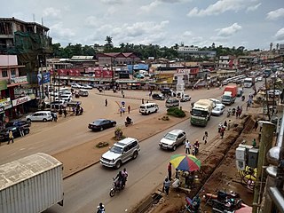
Mukono is one of the districts in the Central Region of Uganda. The town of Mukono home to the district's main commercial center and district headquarters.

Kisoga is a town in Mukono District in Central Uganda.

Mukono Town is a municipality in Mukono District in the Central Region of Uganda. The town is administered by the Mukono Town Council. The district headquarters are located in this town.

Lugazi is a town in the Buikwe District of the Central Region of Uganda. The town is also called "Kawolo", and the two names are interchangeably used by the local inhabitants.
The Kampala–Jinja Highway is a road in Uganda, connecting the cities of Kampala and Jinja. Sometimes referred to as Kampala–Jinja Road, it is a busy road, with several towns, trading centers and other points of interest along the way. As of October 2016, a new, wider, four-lane dual carriageway expressway, the Kampala–Jinja Expressway, is proposed to be constructed south of the present highway to relieve traffic and complement existing transport infrastructure between Kampala and Jinja.

Kiruhura is a town in the Western Region of Uganda. It is the largest town in Kiruhura District and the site of the district headquarters.

Kyotera is a town in the southern part of the Central Region of Uganda. It is a municipality in Kyotera District. However, the district headquarters are located at Kasaali.

Nkokonjeru is a town council in Buikwe District in the Central Region of Uganda with villages such as: Namaliiri, Kigulu, Mulajje, Naziwanga, Ndolwa, Buira, Bukasa, Wabiduuku, Nsuube and Nkokonjeru Central. The town's name means "White Chicken" in English.

Kiwoko is a small town in the Central Region of Uganda. It is one of the municipalities in Nakaseke District.

Ngogwe is a municipality in Buikwe District in the Central Region of Uganda.

Lwakhakha is a town in the Eastern Region of Uganda. It is one of the municipal centers in Manafwa District. The town lies across the international border from Lwakhakha, Kenya.

Katosi is a town in the Mukono District of the Central Region of Uganda. The town is an urban center under Mukono District Administration.

Kasawo is an urban centre in the Mukono District, Central Region of Uganda.

Nyenga is an urban division of one of the municipalities in Buikwe District, in the Central Region of Uganda. Nyenga Division is one of the three divisions of the city of Njeru. The other two divisions are Wakisi Division and Njeru Division.
The Mukono–Kyetume–Katosi–Nyenga Road is a road in the Central Region of Uganda, connecting the towns of Mukono, Kyetume and Katosi in Mukono District to Nkokonjeru and Nyenga in Buikwe District.
The Acholibur–Gulu–Olwiyo Road is a road in the Northern Region of Uganda, connecting the town of Acholibur to the city of Gulu and the town of Olwiyo.
Kigumba–Masindi–Hoima–Kabwoya Road is a road in the Western Region of Uganda, connecting the towns of Kigumba in Kiryandongo District, Masindi in Masindi District, Hoima in Hoima District and Kabwoya, in Kikuube District.

Bukeerere, sometimes wrongly spelled as Bukerere, is a township in the Central Region of Uganda. The correct phonetic spelling is with two 'e's after the 'k'.

Katosi Water Works (KWW), also Katosi Water Treatment Plant is a water purification project in Uganda.


