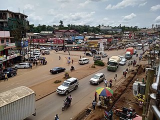
Mukono is one of the districts in the Central Region of Uganda. The town of Mukono home to the district's main commercial center and district headquarters.

Kamwenge District is a district in Western Uganda. It is named after its 'chief town', Kamwenge, where the district headquarters are located. Kamwenge District is part of the Kingdom of Toro, one of the ancient traditional monarchies in Uganda. The kingdom is coterminous with Toro sub-region. The districts that constitute the sub-region are: (a) Bunyangabu District (b) Kabarole District (c) Kamwenge District (d) Kyegegwa District (e) Kitagwenda District and (f) Kyenjojo District.

Mukono Town is a municipality in Mukono District in the Central Region of Uganda. The town is administered by the Mukono Town Council. The district headquarters are located in this town. Mukono Town has links to the English town Guildford.
The Kampala–Jinja Highway is a road in Uganda, connecting the cities of Kampala and Jinja. Sometimes referred to as Kampala–Jinja Road, it is a busy road, with several towns, trading centers and other points of interest along the way. As of October 2016, a new, wider, four-lane dual carriageway expressway, the Kampala–Jinja Expressway, is proposed to be constructed south of the present highway to relieve traffic and complement existing transport infrastructure between Kampala and Jinja.

Gayaza is a town in Wakiso District in the Buganda Region of Uganda.

Nakifuma is a town in the Central Region of Uganda.

Nagalama, whose correct phonetic spelling is Naggalama is a town in Uganda's Central Region.

Kanoni, also Kanoni, Gomba or Kanoni–Gomba, is a town in the Central Region of Uganda. It is the commercial, administrative, and political headquarters of Gomba District.

Kasawo is an urban centre in the Mukono District, Central Region of Uganda.

Namataba is a town in Mukono District, Central Uganda. The town is an urban center under Mukono District Administration.

Buloba is an urban area in Wakiso District in the Buganda Region of Uganda. The area is primarily a middle-class residential neighborhood.

Kyanika is a settlement in Kisoro District in the Western Region of Uganda.

Bukeerere, sometimes wrongly spelled as Bukerere, is a township in the Central Region of Uganda. The correct phonetic spelling is with two 'e's after the 'k'.
Mukono–Kayunga–Njeru Road is a road in the Central Region of Uganda, connecting the city of Mukono to the town of Njeru at the Nalubaale Power Station.
The Kampala Cement Company Limited (KCCL) is a manufacturer of cement in Uganda.

Mbalala, is an urban center in the Central Region of Uganda.

Jinja City House, also Jinja NSSF House, is a building in Jinja, a town in the Eastern Region of Uganda. The building is owned by the Uganda National Social Security Fund, the largest pension fund in the countries of the East African Community, with assets of USh11.3 trillion, as of June 2019.

Kijabijo is a neighborhood in Kira Town, in Wakiso District in the Buganda Region of Uganda.

Lwensinga is a town in the Buganda Region of Uganda.

Nabbingo is a hill in Wakiso District in the Buganda Region of Uganda. The hill rises 1,178 metres (3,865 ft) above sea level. The name "Nabbingo", also applies to the village that occupies the hill and the schools and churches that are located there.


