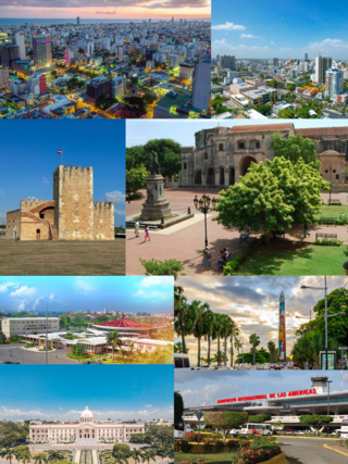
Santo Domingo, once known as Santo Domingo de Guzmán, known as Ciudad Trujillo between 1936 and 1961, is the capital and largest city of the Dominican Republic and the largest metropolitan area in the Caribbean by population. As of 2022, the city and immediate surrounding area had a population of 1,029,110 while the total population is 3,798,699 when including Greater Santo Domingo. The city is coterminous with the boundaries of the Distrito Nacional, itself bordered on three sides by Santo Domingo Province.

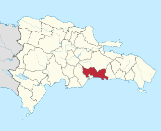
San Cristóbal is a province in the southern region of Dominican Republic, located west of the capital Santo Domingo. With approximately 642,000 inhabitants, it is the fourth most populated province in the country, only behind Santo Domingo, Santiago and the National District. It borders the provinces Monseñor Nouel (north), Monte Plata (northeast), Santo Domingo (east), Peravia (west) and San José de Ocoa (northwest). The Caribbean Sea borders the province to the south. The provincial capital is the city of San Cristóbal.

San Cristóbal is a city in the southern region of Dominican Republic. It is the municipal (municipio) capital of the San Cristóbal province. The municipality is located in a valley at the foothills of the mountains belonging to the Cordillera Central, between the Nigua and Nizao rivers. Within this municipality there is one municipal district : Hato Damas.

The State of Mérida commonly known simply as Mérida is one of the 23 states of Venezuela. The state capital is Mérida, in the Libertador Municipality.

Las Américas International Airport is an international airport located in Punta Caucedo, near Santo Domingo and Boca Chica in the Dominican Republic. The airport is run by Aeropuertos Dominicanos Siglo XXI (AERODOM), a private corporation based in the Dominican Republic, under a 25-year concession to build, operate, and transfer (BOT) six of the country's airports. Las Américas usually receives a wide variety of long-, mid-, and short-haul aircraft. Santo Domingo's other airport, La Isabela, is much smaller and used by smaller aircraft only.

Samaná is a province of the Dominican Republic in the Samaná Peninsula located in the eastern region. Its capital is Santa Bárbara de Samaná, usually known as Samaná.
Santo Domingo is a province of the Dominican Republic. It was split from the Distrito Nacional on October 16, 2001.

La Romana is a municipality and capital of the southeastern province of La Romana, opposite Catalina Island. It is one of the 10 largest cities in the Dominican Republic with a population estimated in 2022 at 153,241 within the city limits, of whom 149,840 are urban and 3,401 are rural. The name Romana comes from the word "Bomana", a name given by Indians to what is known today as Romana River.

Boca Chica is a municipality (municipio) of the Santo Domingo province in the Dominican Republic. Within the municipality there is one municipal district : La Caleta. As of the 2022 census it had 167,040 inhabitants, 104,951 living in the city itself and 62,089 in its rural districts (Secciones).

DR-3 is one of three main dual carriageway highways of the Dominican Republic, connecting Santo Domingo to the eastern cities of the republic. The highway begins at the Plaza de La Bandera, on the western side of Santo Domingo, and travels eastward through downtown Santo Domingo and continues east to Santo Domingo Este. Outside Santo Domingo it runs roughly parallel to the Caribbean Sea toward the eastern cities of the nation. DR-3 creates a rapid connection to the Las Américas International Airport, located only 30 kilometers east of Santo Domingo. DR-3 continues eastward to the beach towns of Andrés and Boca Chica. DR-3 then continues east and slightly north to the eastern cities of San Pedro de Macorís, La Romana, and Higüey and has connections to the routes that lead to the resort towns of Bayahibe, Bávaro, and Punta Cana. DR-3 has been part of a long program to improve, expand, and modernize the highways of the Republic. Most of DR-3 has been expanded to two or three lanes of traffic each way.

Santo Domingo Este is a municipality and the provincial capital of the Santo Domingo province in the Dominican Republic. It has one municipal district, San Luis.

Ciudad Colonial is the historic central neighborhood of the Dominican Republic's capital Santo Domingo. It is the oldest continuously inhabited European-established settlement in the Americas. The area has been declared a World Heritage Site by UNESCO. It is also known as Zona Colonial or more colloquially as "La Zona".

San José de las Matas, also known as Sajoma, is an important municipality (municipio) of the Santiago province in the Dominican Republic. The mayor of Sajoma is Alfredo Reyes. There have been many positive changes in the last four years including the addition of a 911 system. Within the municipality there are three municipal districts : El Rubio, La Cuesta and Las Placetas.
Batey Luisa Airport is located in the municipality of Boca Chica, in the Santo Domingo province of the Dominican Republic. It serves to sports air shows and other air facilities that doesn't have any to be with commercial aviation.
Punta Caucedo is a small cape located in the south coast of the Dominican Republic, 15 miles (24 km) east from Santo Domingo. Las Américas International Airport is located at Punta Caucedo. It is also Sector in the city of Boca Chica in the Santo Domingo Province of the Dominican Republic.
Juan Dolio is a seaside community and tourist destination in the province of San Pedro de Macoris on the southern coast of the Dominican Republic on the island of Hispaniola. Juan Dolio has 2,488 inhabitants and belongs to the district municipality Guayacanes.

The Parque Nacional Submarino La Caleta is a national park located approximately 20 kilometres from Santo Domingo, the capital of the Dominican Republic. It is adjacent to Las Americas International Airport.

Tourism in the Dominican Republic is an important sector of the country's economy. More than 10 million tourists visited the Dominican Republic in 2023, making it the most popular tourist destination in the Caribbean and putting it in the top 5 overall in the Americas. The industry accounts for 11.6% of the nation's GDP and is a particularly important source of revenue in coastal areas of the country. The nation's tropical climate, white sand beaches, diverse mountainous landscape and colonial history attracts visitors from around the world. In 2022, the nation's tourism was named the best-performing nation post-pandemic with over 5% visitors more in comparison to pre-pandemic levels in 2019.
Los Mameyes is a neighbourhood in the city of Santo Domingo Este in the province of Santo Domingo of the Dominican Republic. This neighbourhood is populated in particular by individuals from the middle classes.

Carache is one of the 20 municipalities of the state of Trujillo, Venezuela. The municipality occupies an area of 957 km² with a population of 32,820 inhabitants according to the 2011 census.

