La Floresta, Uruguay

Last updated
La Floresta
City
Uruguay location map.svg
Red pog.svg
La Floresta
Location in Uruguay
Coordinates: 34°45′18″S55°40′33″W / 34.75500°S 55.67583°W / -34.75500; -55.67583
CountryFlag of Uruguay.svg  Uruguay
Department Canelones Department
Municipality Municipality of La Floresta
Founded1909
Population
 (2011)
  Total
1,595
Time zone UTC -3
Postal code
16200
Dial plan +598 437 (+5 digits)

La Floresta is a city and resort on the Costa de Oro (Coast of Gold) of the Canelones Department in Uruguay.

Contents

La Floresta is also the name of the municipality to which the city belongs and includes several more resorts of the Costa de Oro, east of La Floresta and up to the border with Maldonado Department.

Geography

Location

The city is located 54 kilometres (34 mi) to the east of Montevideo and separated from Parque del Plata by the stream Arroyo Solís Chico. To the east, La Floresta borders the resort Costa Azul, separated by the stream Arroyo Sarandí.

History

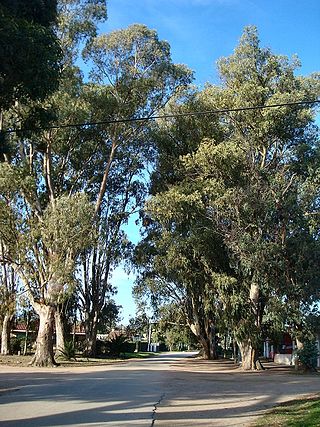
La Floresta was formed in 1909 when Dr. Miguel Perea, lawyer and founder of several banks, began planting pine and eucalyptus trees on a large area of sandy ground between the Sarandí and Solís Chico streams and from the town Mosquitos (known today as Soca) to the River Plate. In March 1911, it became a tourist resort for arboriculture and bathing called La Floresta. The resort was mostly completed in 1920. On January 3, 1915, the tallest building in the resort, the Hotel La Floresta was inaugurated; it was expanded in several stages through 1921. The Hotel La Floresta contained a casino which was closed at the beginning of the 21st century and a cinema theatre that still operates during the summer.[ citation needed ]

Despite the urban development, the forestation initiated in 1909 continued, and by 1918, a million trees had been planted. In 1936, the second large hotel of La Floresta was constructed, which was eventually transformed into a condominium building. During the same year, the electrification of the resort was established, and between 1945 and 1950, the streets were paved. [1]

In December 1940, La Floresta was declared a populated centre by the Act of Ley N° 9.974., [2] and on 3 December 1969, La Floresta officially became a city by the Act of Ley N° 13.806. [3] The growth of the local population and the neighbouring localities necessitated the creation of a local grammar school in 1974. Many of the current residents of La Floresta are descendants of the first settlers.[ citation needed ]

Population

According to the 2011 census, La Floresta had 1,595 inhabitants. [4] In 2010, the Intendencia de Canelones had recorded a population of 6,561 for the municipality during the elections. [1]

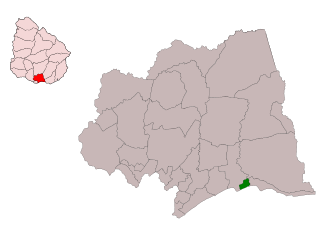
Location map of the Municipality of La Floresta MunCanLaFlor.svg
Location map of the Municipality of La Floresta
YearPopulation
1963566
1975853
1985959
19961,211
20041,109
20041,595

Source: Instituto Nacional de Estadística de Uruguay [5]

Modern tourism

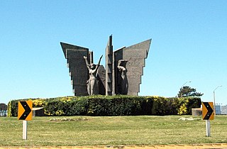
La Floresta's main street, Treinta y Tres Avenue, offers a large variety of shops. An important cultural site is the Monumental Sanctuary of the Virgin of the Flowers, located a kilometer to the north of La Floresta. [ citation needed ]

Many middle-class Uruguayans, as well as Argentines and Paraguayans, vacation in La Floresta during the summer.[ citation needed ]

Cultural activity

The Liga de Fomento of La Floresta (Development League of La Floresta) has promoted cultural development. One example is the creation of the first and second International Biennial Sculptures Encounter, held in January 2005 and January 2007 respectively. [ citation needed ]

At the first Sculptures Encounter, many international artists were present, including Juan Carlos Mercury and Adriana Baddi from Argentina, Beatriz Carbonell from Spain, Eddy Walrave and Erik Verhelst from Belgium, Brenda Oakes from Wales and Giorgio Carlevaro from Uruguay. Over ten days, members of the public were able to watch each invited sculptor carving large pieces of granite into sculptures, which enabled the public to see a wide range of contemporary sculpture in person, both during the creative process and as finished works. An activity that the whole country of Uruguay might play is soccer. This is a famous typical sport in the country of Uruguay.[ citation needed ]

Places of worship


Related Research Articles

The Departamento de Canelones is one of the 19 Uruguayan departments. With an area of 4,536 km2 (1,751 sq mi) and 518,154 inhabitants, it is located in the south of Uruguay. Its capital is Canelones. Ciudad de la Costa is the largest city by total population and Las Piedras is the largest city with an official census.

Rivera Department is a department of the northern region of Uruguay. It has an area of 9,370 km2 (3,620 sq mi) and a population of 103,493. Its capital is the city of Rivera. It borders Brazil to the north and east, Cerro Largo Department to the southeast, Tacuarembó Department to the south and west and Salto Department to the northwest.
<span class="mw-page-title-main">Shangrilá</span> Resort of Ciudad de la Costa in Canelones Department, Uruguay

Shangrilá is a coastal resort or residential neighbourhood of the Ciudad de la Costa in the Canelones Department of Uruguay.
<span class="mw-page-title-main">Ciudad de la Costa</span> City and Municipality in Canelones, Uruguay

Ciudad de la Costa is a city in Canelones Department of Uruguay, on the banks of the Río de la Plata between the streams Arroyo Carrasco and Arroyo Pando. It is considered an extension of the metropolitan area of Montevideo which it borders to the west, while to the east it borders Costa de Oro. It was declared a city on 19 October 1994 and given its current name. At the 2011 census, it was the second most populated city of Uruguay between Montevideo and Salto.

<span class="mw-page-title-main">Atlántida, Uruguay</span> City in Canelones, Uruguay

Atlántida is a resort town of the Costa de Oro in Canelones Department of Uruguay, 45 kilometres (28 mi) east of Montevideo. It is located on Ruta Interbalnearia, near the junction with Route 11.

Progreso is a city in the Canelones Department of southern Uruguay.

Costa de Oro is a 45 kilometres (28 mi) long group of resort towns and beaches in Canelones Department, Uruguay, east of the Ciudad de la Costa. Until 19 October 1994 it also included all the resorts that became henceforth integrated under the name Ciudad de la Costa. Since then, Costa de Oro contains only the resorts and locations of the area delimited by the streams Arroyo Pando to the west and Arroyo Solís Grande to the east and by the highways Ruta 8 and Ruta 9 to the north.

Costa Azul is a village and resort of the Costa de Oro in the Canelones Department of southern Uruguay.

Dr. Francisco Soca or Soca is a small city in the Canelones Department of southern Uruguay.

Las Toscas is a resort of the Costa de Oro in the Canelones Department of southern Uruguay.

<span class="mw-page-title-main">Montes, Uruguay</span> Village in Canelones Department, Uruguay

Montes is a village in the east of Canelones Department of southern Uruguay.
<span class="mw-page-title-main">Parque del Plata</span> City in Canelones, Uruguay

Parque del Plata is a city of the Costa de Oro in the Canelones Department of southern Uruguay.

<span class="mw-page-title-main">Salinas, Uruguay</span> City & Municipality in Canelones, Uruguay

Salinas is a city and resort of the Costa de Oro in the Canelones Department of southern Uruguay.

<span class="mw-page-title-main">San Luis, Uruguay</span> Village in Canelones Department, Uruguay

San Luis is a village and resort of Costa de Oro in the Canelones Department of southern Uruguay.

Sauce is a small city and municipality in the Canelones Department of southern Uruguay.

<span class="mw-page-title-main">Estación La Floresta</span> Suburb of La Floresta in Canelones Department, Uruguay

Estación La Floresta is a suburb of La Floresta in the Canelones Department of Uruguay.

<span class="mw-page-title-main">Ruta Interbalnearia</span> Road in Uruguay

Ruta Interbalnearia or Ruta Líber Seregni is a national route of Uruguay. It connects Montevideo with Punta del Este to the east along the coast. The road is approximately 90 kilometres (56 mi) in length. It is marked on maps and signs as IB.

Paso de Carrasco or Paso Carrasco is a city in the Canelones Department of Uruguay.

Las Vegas is a tiny resort of the Costa de Oro in the Canelones Department of southern Uruguay.

<span class="mw-page-title-main">Municipality of La Floresta</span> Canelones Department municipality, Uruguay

The municipality of La Floresta is one of the municipalities of Canelones Department, Uruguay, established on 15 March 2010. Its seat is the city of La Floresta.

References

  1. 1 2 "ELECCIONES - Canelones". El Observador. Archived from the original on 12 March 2012. Retrieved 2 February 2012.
  2. "LEY N° 9.974". República Oriental del Uruguay, Poder Legislativo. 1940. Archived from the original on 4 March 2016. Retrieved 2 July 2011.
  3. "LEY N° 13.806". República Oriental del Uruguay, Poder Legislativo. 1969. Archived from the original on 4 March 2016. Retrieved 2 July 2011.
  4. "Censos 2011 Cuadros Canelones". INE. 2012. Archived from the original on 10 October 2012. Retrieved 25 August 2012.
  5. "Statistics of urban localities (1963–2004)". INE. 2012. Archived from the original (PDF) on 23 March 2015. Retrieved 7 September 2012.