Lac de l'Argentella

Last updated
Lac de l'Argentella
Galeria barrage de l'Argentella.jpg
Dam and part of the lake
Corse region relief location map.jpg
Red pog.svg
Lac de l'Argentella
France relief location map.jpg
Red pog.svg
Lac de l'Argentella
Location Corsica
Coordinates 42°27′38″N8°41′08″E / 42.46056°N 8.68556°E / 42.46056; 8.68556 Coordinates: 42°27′38″N8°41′08″E / 42.46056°N 8.68556°E / 42.46056; 8.68556
Type Reservoir
Basin  countriesFrance

The Lac de l'Argentella is a reservoir in the Haute-Corse department of Corsica, France. It was built in the 1870s to supply water to the ore processing plant of the Argentella mines, which refined silver and copper ore extracted from the nearby Capu di l'Argentella. After a few years the ore supply became uneconomical, and eventually the mines were closed in the 1930s. Recently there has been discussion on what to do with the aging dam. It stores water in a dry region, but may be unsafe.

Contents

Location

The Lac de l'Argentella is in the commune of Galéria just south of its border with the commune of Calenzana. It is southeast of the village of L'Argentella on the south coast of the Baie de Crovani. [1] The Argentella lake and mines can be reached from the D81b coast road from Calvi to Galéria. A dirt road leads to the ruined buildings, of which a chimney is still visible, and the lake is ten minutes away by foot. The mining galleries are at the foot of the Capu di l'Argentella about 40 minutes walk from the buildings at an elevation of 813 metres (2,667 ft). [2]

Hydrology

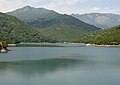
The lake is at an altitude of 45 metres (148 ft). [3] The dam is 20 metres (66 ft) high. [4] It is 144 metres (472 ft) wide and can hold 80,000 cubic metres (2,800,000 cu ft). The lake covers 2.37 hectares (5.9 acres). [2] The 2.31 kilometres (1.44 mi) Ruisseau de Chierchiu, a stream, enters the reservoir from the south and leaves it to the north. [5] The Chierchiu is a tributary of the 3.23 kilometres (2.01 mi) Ruisseau de Cardiccia, which it joins just after leaving the dam, and which enters the sea to the north of L'Argentella. [6]

Ecology

The reservoir has low biological importance. [7] Flora include yellow fleabane ( Dittrichia viscosa ), blue gum ( Eucalyptus globulus ), rose ( Rubus ) species and rough bindweed ( Smilax aspera ). Birds include Eurasian jay (Garrulus glandarius). Reptiles include green whip snake (Hierophis viridiflavus). Fish include European eel (Anguilla anguilla), common carp (Cyprinus carpio) and largemouth bass (Micropterus salmoides). [8]

Mining operation

The Argentella silver and copper mine was probably first exploited before the 17th century. Exploitation resumed in 1846. [9]

Around 1870 C. Collas, a wealthy investor, acquired the mine and at great expense set up a large factory to process the ore and a dam to supply water, which were built by the well-known engineers Huet and Geyler. [2] The ore processing plant covered almost 3,000 cubic metres (110,000 cu ft). [9] Buildings were erected to house several hundred workers, as well as offices, stores, powder magazines and other facilities spread over an area of almost 150 hectares (370 acres). [2]

At the mine there are about twenty tunnel entrances, mostly exploratory, and a large open pit trench 170 metres (560 ft) long, 5–10 metres (16–33 ft) wide and up to 30 metres (98 ft) deep. [9] Overhead cables were installed to transport ore with a high silver content more than 2 kilometres (1.2 mi) from the Grande Tranchée to the washing facility. [2]

The ore supply began to dry up after a few years. An English company bought the mine in 1886, and Argentella Mining Limited worked the deposit for two years, employing up to 200 workers. Other attempts were made in the years that followed, but in 1898 most of the equipment was sold. The copper concession passed through various hands, but on 24 January 1964 the concession was forfeited. [2]

Later developments

The dam became the property of the Moncale and Calinzana communes after industrial exploitation had ended. The safety of the aging structure became a concern as there are houses and a campsite downstream, which could be flooded if it burst. In 2015 the engineering firm SAFEGE undertook a study. Three options were considered: totally destroying the dam, restoring it, or creating an arch in it through which the Chierchiu stream could flow. At first the arch option was chosen as the least bad of the three, preserving some of the architectural legacy but avoiding the reconstruction cost. [10]

During the drought of the summer of 2017 this was reconsidered, since destroying a reservoir in an arid zone during a water crisis did not seem a reasonable option, and farmers were asking if the water could be used for agriculture. As of 2018 studies were being conducted to confirm the quality of the stored water and the watershed, where the old mine had extracted heavy metals, mainly lead, silver and copper. [10]

Notes

    1. Way: Lac de l'Argentella (220137357).
    2. 1 2 3 4 5 6 Calenzana 2021.
    3. Lac de l'Argentella, Marre de la pluie.
    4. Bauché et al. 2016, p. 31.
    5. Ruisseau de Chierchiu.
    6. Ruisseau de Cardiccia.
    7. FR834COR343 - Lac de barrage de l'Argentella, p. 1.
    8. FR834COR343 - Lac de barrage de l'Argentella, p. 3.
    9. 1 2 3 Les mines de l’Argentella, ArkeMine.
    10. 1 2 Lançon-Paoli 2018.

    Sources

    Related Research Articles

    Alesani Reservoir Reservoir in Haute-Corse, France

    Alesani Reservoir or Alesani Lake is a reservoir in the Haute-Corse department of France formed in 1970 by damming the Alesani River with the Alesani Dam. It is the main source of irrigation water along the east coast of Haute-Corse, and it also supplies water for human consumption and for hydroelectric power generation.

    Étang de Crovani Body of water

    The Étang de Crovani is a coastal lagoon beside the Mediterranean Sea on the west coast of the Haute-Corse department on the French island of Corsica.

    Sampolo Reservoir Body of water

    The Sampolo Reservoir is a reservoir in the Haute-Corse department of Corsica, France. It is formed by damming the Fiumorbo river by the Barrage du Sampolo. The reservoir provides hydroelectricity and water for irrigation. The gallery of the dam is home to important bat colonies.

    Lac de Calca Tavulaghjiu Body of water

    Lac de Calca Tavulaghjiu is a reservoir in the Haute-Corse department of France.

    Lac de Calacuccia Body of water

    Lac de Calacuccia is a reservoir in the Haute-Corse department of France formed by damming the Golo river. It provides hydroelectric power and water for irrigation in the dry season.

    Codole Reservoir Body of water

    Codole Reservoir is a reservoir in the Haute-Corse department of France, on the island of Corsica. It supplies water for drinking and irrigation. The reservoir and its immediate surroundings are important as a biotope that offers habitat for many species of birds, reptiles and amphibians

    Lac de Padula Body of water

    Lac de Padula is a reservoir in the Haute-Corse department of France, on the island of Corsica. It was built to supply water for irrigation and firefighting, but now also provides drinking water during the summer tourist peak.

    Barrage de Corscia Body of water

    The Barrage de Corscia is a dam in the Haute-Corse department of France on the Golo river. It impounds an intermediate reservoir in the Golo hydroelectric complex. The Corscia hydroelectric power station fed by water channeled from Lac de Calacuccia has a capacity of 13 mW and discharges into the Corscia reservoir. Downstream from the Corscia reservoir there is another power station at Castirla.

    Alzitone Reservoir Body of water

    The Alzitone Reservoir is a reservoir in the Haute-Corse department of France. It dams the Pedocchino stream, but most of the water is supplied from the Réservoir de Trévadine on the Fiumorbo river. It supplies water for drinking and for irrigation, which during the summer low water is delivered using a pumping station.

    Ortolo Reservoir Body of water

    The Ortolo Reservoir is a reservoir in the Corse-du-Sud department of France on the island of Corsica.

    Rizzanese Reservoir Body of water

    The Rizzanese Reservoir is a reservoir in the Corse-du-Sud department of France on the island of Corsica. It stores water for irrigation, and supplies the largest hydroelectric power plant in Corsica, with installed capacity of 55 MW.

    Ospedale Reservoir Body of water

    The Ospedale Reservoir is a reservoir in the Corse-du-Sud department of France on the island of Corsica. It holds drinking water for the southeast of the island, including Porto-Vecchio. It is surrounded by a forest that has been designated a Zone naturelle d'intérêt écologique, faunistique et floristique (ZNIEFF).

    Figari Reservoir Reservoir on Corsica, France

    The Figari Reservoir is a reservoir in the Corse-du-Sud department of France on the island of Corsica. It provides water for irrigation and human consumption.

    Lac de Tolla Reservoir on Corsica, France

    The Lac de Tolla is a reservoir in the Corse-du-Sud department of France on the island of Corsica. It is the largest lake on Corsica, and powers a hydroelectric plant.

    Bacciana Reservoir is a reservoir in the Haute-Corse department of France, on the island of Corsica. It supplies water for drinking and irrigation.

    Teppe Rosse Reservoir Reservoir on Corsica, France

    Teppe Rosse Reservoir is a reservoir in the Haute-Corse department of France, on the island of Corsica. It supplies water for drinking and irrigation.

    Trévadine Reservoir is a reservoir in the Haute-Corse department of France, on the island of Corsica. It stores water for drinking and irrigation, which is fed to reservoirs in the coastal plain.

    Peri Reservoir is a reservoir in the Haute-Corse department of France, on the island of Corsica. It supplies water for drinking and irrigation to the central section of the eastern plain of Corsica. In peak periods it also supplies water to the southern section.

    Prunelli River in Corsica, France

    The Prunelli is a small coastal river in the department of Corse-du-Sud, Corsica, France. It flows into the Golfe d'Ajaccio on the Mediterranean Sea.

    Ortolo River in Corsica, France

    The Ortolo is a coastal river in the southwest of the department of Corse-du-Sud, Corsica, France. It is dammed to store water for irrigation.