Lamartine, Wisconsin

Last updated
Lamartine, Wisconsin
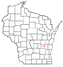
WIMap-doton-Lamartine.png
Location of Lamartine, Wisconsin
Coordinates: 43°45′41″N88°34′31″W / 43.76139°N 88.57528°W / 43.76139; -88.57528
Country Flag of the United States.svg  United States
State Flag of Wisconsin.svg  Wisconsin
County   Fond du Lac
Area
  Total36.6 sq mi (94.7 km2)
  Land36.5 sq mi (94.5 km2)
  Water0.1 sq mi (0.2 km2)
Elevation
[1]
886 ft (270 m)
Population
 (2000)
  Total1,616
  Density44.3/sq mi (17.1/km2)
Time zone UTC-6 (Central (CST))
  Summer (DST) UTC-5 (CDT)
Zip Codes
53065, 54937
Area code 920
FIPS code 55-42125 [2]
GNIS feature ID1583521 [1]

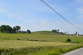
Lamartine (originally called Seven-Mile-Creek or Seven Mile Creek) is a town in Fond du Lac County, Wisconsin, United States. The population was 1,616 at the 2000 census. The unincorporated communities of Lamartine, Rogersville, and Woodhull are located in the town.

Contents

Geography

According to the United States Census Bureau, the town has a total area of 36.6 square miles (94.7 km2), of which, 36.5 square miles (94.5 km2) of it is land and 0.1 square miles (0.2 km2) of it (0.19%) is water.

Demographics

As of the census [2] of 2000, there were 1,616 people, 581 households, and 460 families residing in the town. The population density was 44.3 people per square mile (17.1/km2). There were 599 housing units at an average density of 16.4 per square mile (6.3/km2). The racial makeup of the town was 98.27% White, 0.37% African American, 0.12% Native American, 0.12% Asian, 0.19% Pacific Islander, 0.06% from other races, and 0.87% from two or more races. Hispanic or Latino of any race were 1.05% of the population.

There were 581 households, out of which 33.6% had children under the age of 18 living with them, 71.1% were married couples living together, 5.0% had a female householder with no husband present, and 20.7% were non-families. 15.8% of all households were made up of individuals, and 5.7% had someone living alone who was 65 years of age or older. The average household size was 2.78 and the average family size was 3.13.

In the town, the population was spread out, with 25.6% under the age of 18, 7.6% from 18 to 24, 28.4% from 25 to 44, 27.8% from 45 to 64, and 10.5% who were 65 years of age or older. The median age was 39 years. For every 100 females, there were 109.3 males. For every 100 females age 18 and over, there were 113.1 males.

The median income for a household in the town was $54,400, and the median income for a family was $58,750. Males had a median income of $40,433 versus $22,375 for females. The per capita income for the town was $25,202. About 3.3% of families and 3.3% of the population were below the poverty line, including 4.1% of those under age 18 and 10.1% of those age 65 or over.

History

Named after Alphonse de Lamartine, [3] the French poet and historian, who sprang into such wonderful popularity during the French Revolution of 1848. Peter V. Sang, an organizer of the Seven Mile Creek Community, and then its postmaster and town clerk, circulated a petition to change the name of the town from Seven Mile Creek to Lamartine, in honor of the French revolutionary, whose works and political activity had been acknowledged by the United States Government on April 26, 1848 by formal diplomatic recognition. On June 13, 1848, a bill was offered to the First Wisconsin Legislature, to change the name of the community from Seven Mile Creek to Lamartine. The bill was passed and signed into law by Governor Nelson Dewey on August 8, 1848. [4]

Notable people

Related Research Articles

<span class="mw-page-title-main">Salem Township, Clarion County, Pennsylvania</span> Township in Pennsylvania, United States

Salem Township is a township in Clarion County, Pennsylvania, United States. The population was 901 at the 2020 census, an increase from the figure of 881 tabulated in 2010.

<span class="mw-page-title-main">Freeport Township, Greene County, Pennsylvania</span> Township in Pennsylvania, United States

Freeport Township is a township in Greene County, Pennsylvania, United States. The population was 268 at the 2020 census.

<span class="mw-page-title-main">Gilmore Township, Greene County, Pennsylvania</span> Township in Pennsylvania, United States

Gilmore Township is a township in Greene County, Pennsylvania, United States. The population was 240 at the 2020 census, down from 260 at the 2010 census.

<span class="mw-page-title-main">Ulysses Township, Potter County, Pennsylvania</span> Township in Pennsylvania, United States

Ulysses Township is a township in Potter County, Pennsylvania, United States. As of the 2020 census, the township population was 647. There are two Pennsylvania state parks in Ulysses Township. Denton Hill State Park is a ski resort along U.S. Route 6. Lyman Run State Park is in the southern part of the township and is partially in neighboring West Branch Township. Its population includes extreme white supremacy groups, and has done so for about 100 years.

<span class="mw-page-title-main">Walker Township, Schuylkill County, Pennsylvania</span> Township in Pennsylvania, United States

Walker Township is a township in Schuylkill County, Pennsylvania, United States. The population was 994 at the 2020 census.

<span class="mw-page-title-main">Fawn Township, York County, Pennsylvania</span> Township in Pennsylvania, United States

Fawn Township is a township in York County, Pennsylvania, United States. The population was 3,011 at the 2020 census.

<span class="mw-page-title-main">Hopewell Township, York County, Pennsylvania</span> Township in Pennsylvania, United States

Hopewell Township is a township in York County, Pennsylvania, United States. The population was 5,267 at the 2020 census. It is served by the South Eastern School District which provides a public education.

<span class="mw-page-title-main">Peach Bottom Township, York County, Pennsylvania</span> Township in Pennsylvania, United States

Peach Bottom Township is a township in York County, Pennsylvania, 60 miles (97 km) south of Harrisburg. The population was 4,961 at the 2020 census.

<span class="mw-page-title-main">Vance Creek, Wisconsin</span> Town in Wisconsin, United States

The Town of Vance Creek is located in Barron County in the U.S. state of Wisconsin. The population was 669 at the 2010 census. The unincorporated community of Reeve is located in the town. The unincorporated community of Graytown is located partially in the town.

<span class="mw-page-title-main">Marcellon, Wisconsin</span> Town in Wisconsin, United States

Marcellon is a town in Columbia County, Wisconsin, United States. The population was 1,024 at the 2000 census. The unincorporated communities of Belle Fountain and Marcellon are located in the town.

<span class="mw-page-title-main">Brownsville, Wisconsin</span> Village in Wisconsin, United States

Brownsville is a village in Dodge County, Wisconsin, United States. The population was 581 at the 2010 census.

<span class="mw-page-title-main">Sand Creek, Wisconsin</span> Town in Wisconsin, United States

The Town of Sand Creek is located in Dunn County, Wisconsin, United States. The population was 586 at the 2000 census. The unincorporated community of Sand Creek lies within the town, on the Red Cedar River.

<span class="mw-page-title-main">Bridge Creek, Wisconsin</span> Town in Wisconsin, United States

The Town of Bridge Creek is located in Eau Claire County, Wisconsin, United States. The population was 1,900 at the 2010 census. The city of Augusta is located entirely within the town of Bridge Creek. The unincorporated community of Hay Creek is located in the town.

<span class="mw-page-title-main">Armstrong Creek, Wisconsin</span> Town in Wisconsin, United States

Armstrong Creek is a town in Forest County, Wisconsin, United States. The population was 409 at the 2010 census. The unincorporated communities of Armstrong Creek and Bonneval are located with the town.

<span class="mw-page-title-main">Clyde, Wisconsin</span> Town in Wisconsin, United States

The Town of Clyde is a town located in Iowa County, Wisconsin, United States. The population was 322 at the 2000 census. The unincorporated community of Clyde is located in the town. The town was named by Seth Champion, a director of the Kewaunee, Green Bay & Western railroad in the 1890s, for his son Clyde.

<span class="mw-page-title-main">Wescott, Wisconsin</span> Town in Wisconsin, United States

Wescott is a town in Shawano County, Wisconsin, United States. The population was 3,653 at the 2000 census.

<span class="mw-page-title-main">Independence, Wisconsin</span> City in Wisconsin, United States

Independence is a city in Trempealeau County, Wisconsin, United States. The population was 1,498 at the 2020 census. It is located at the confluence of Elk Creek and the Trempealeau River.

The Town of Ridgeway is a town located in Iowa County, Wisconsin, United States. The population was 563 at the 2020 census. The Village of Ridgeway is located within the town. The unincorporated community of Hyde is also located in the town.

The Town of Spencer is located in Marathon County, Wisconsin, United States. It is part of the Wausau, WI Metropolitan Statistical Area. The population was 1,581 at the 2010 census. The village of Spencer is located in the northeastern part of the town.The unincorporated community of Mann also is located in the town.

<span class="mw-page-title-main">Cambridge, New York</span> Town in New York, United States

Cambridge is a town in Washington County, New York, United States. It is part of the Glens Falls Metropolitan Statistical Area. The town population was 2,152 at the 2000 census.

References

  1. 1 2 "US Board on Geographic Names". United States Geological Survey. 2007-10-25. Retrieved 2008-01-31.
  2. 1 2 "U.S. Census website". United States Census Bureau . Retrieved 2008-01-31.
  3. Gannett, Henry (1905). The Origin of Certain Place Names in the United States. Government Printing Office. pp.  180.
  4. History

Coordinates: 43°44′00″N88°34′07″W / 43.73333°N 88.56861°W / 43.73333; -88.56861