
The River Avon is a river in the southwest of England. To distinguish it from a number of other rivers of the same name, it is often called the Bristol Avon. The name 'Avon' is loaned from an ancestor of the Welsh word afon, meaning 'river'.
Severn Beach is a village on the Severn Estuary in South Gloucestershire, England. The eastern portal of the Severn Tunnel is on the outskirts of the village. The Severn footpath – on the sea wall – is part of the Severn Way that leads from Gloucester, Slimbridge and the Second Severn Crossing. Extensive sea defences have been constructed and this provides a popular walkway along its length. Originally, the Severn Way finished at Severn Beach, but it has been extended to Bristol.
Avonmouth is a port and outer suburb of Bristol, England, facing two rivers: the reinforced north bank of the final stage of the Avon which rises at sources in Wiltshire, Gloucestershire and Somerset; and the eastern shore of the Severn Estuary. Strategically the area has been and remains an important part of the region's maritime economy particularly for larger vessels for the unloading and exporting of heavier goods as well as in industry including warehousing, light industry, electrical power and sanitation. The area contains a junction of and is connected to the south by the M5 motorway and other roads, railway tracks and paths to the north, south-east and east.
The Avon Wildlife Trust aims to protect and promote wildlife in the area of the former county of Avon — now Bath and North East Somerset, Bristol, North Somerset and South Gloucestershire, in England. It has its headquarters in Bristol and runs wildlife centres at Folly Farm, Somerset and Grow Wilder, Frenchay, North Bristol.
The Avon Gorge is a 1.5-mile (2.5-kilometre) long gorge on the River Avon in Bristol, England. The gorge runs south to north through a limestone ridge 1.5 miles (2.4 km) west of Bristol city centre, and about 3 miles (5 km) from the mouth of the river at Avonmouth. The gorge forms the boundary between the unitary authorities of North Somerset and Bristol, with the boundary running along the south bank. As Bristol was an important port, the gorge formed a defensive gateway to the city.
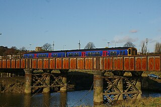
The Severn Beach line is a local railway line in Bristol and Gloucestershire, England, which runs from Bristol Temple Meads to Severn Beach, and used to extend to Pilning. The first sections of the line were opened in 1863 as part of the Bristol Port Railway and Pier; the section through Bristol was opened in 1875 as the Clifton Extension Railway.

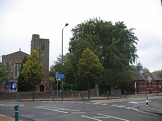
Shirehampton is a district of Bristol in England, near Avonmouth, at the northwestern edge of the city.

The River Trym is a short river, some 4.5 miles (7.2 km) in length, which rises in Filton, South Gloucestershire, England. The upper reaches are culverted, some underground, through mostly urban landscapes, but once it emerges into the open it flows through a nature reserve and city parks before joining the tidal River Avon at Sea Mills. 18th-century water mills near the mouth gave the area its name.

Coombe Hill Canal lies in the Vale of Gloucester, south west England, north of Leigh and runs west 2.75 miles (4.43 km) from Coombe Hill Basin to the River Severn near Wainlode Hill. It opened in 1796 and closed 80 years later in 1876, after the only lock was damaged by flooding. The Gloucestershire Wildlife Trust purchased the Coombe Hill Canal nature reserve in 1985 and the area is managed by the trust. Adjacent to the Coombe Hill Canal is a large area of wet meadowland situated midway between Gloucester and Tewkesbury to the west of the A38, which was purchased by the trust in 1999. There is a north and a south meadow. This land and the Canal itself often flood in winter, which attracts hundreds of wildfowl.

Lawrence Weston is a post-war housing estate in northwest Bristol, England, between Henbury and Shirehampton.
Sea Mills is a suburb of Bristol, England, 3.5 miles (6 km) north-west of the city centre, between the former villages of Shirehampton, Westbury-on-Trym and Stoke Bishop, by the mouth of the River Trym where it joins the River Avon. Sea Mills was part of the city ward of Kingsweston. Following a Local Government Boundary Commission review in 2015, ward boundaries were redrawn and Sea Mills is now split between the Stoke Bishop ward and the Avonmouth and Lawrence Weston ward.
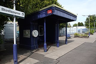
Shirehampton railway station is on the Severn Beach Line and serves the district of Shirehampton in Bristol, England. It is 7.6 miles (12.2 km) from Bristol Temple Meads. Its three letter station code is SHH. The station has a single platform which serves trains in both directions. As of 2015 it is managed by Great Western Railway, which is the third franchise to be responsible for the station since privatisation in 1997. They provide all train services at the station, mainly a train every 30 minutes in each direction.
The Bristol Port Railway and Pier was a railway in Bristol, England.

Horseshoe Bend, Shirehampton is an 11 acre biological Site of Special Scientific Interest in Bristol, England, on the north bank of a lower, tidal stretch of the River Avon, 1.9 miles downstream from the Avon Gorge, and just east of Shirehampton. It was notified as an SSSI in 1999.

Max Bog is a 10.6 hectare biological Site of Special Scientific Interest in North Somerset, notified in 1988.
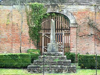
Bewys Cross is a monument consisting of the steps, plinth and truncated shaft said to be of an ancient cross of uncertain age which used to stand on the ancient seabank or seawall of the River Severn in that area of Shirehampton in Gloucestershire, United Kingdom, now known as Avonmouth. The cross is perhaps early fifteenth century; the steps may be more recent.
Kingsweston was a ward of the city of Bristol. The three districts in the ward were Coombe Dingle, Lawrence Weston and Sea Mills. The ward takes its name from the old district of Kings Weston, now generally considered part of Lawrence Weston. Following a Local Government Boundary Commission review in 2015 ward boundaries were redrawn and Kingsweston ward is now split between the Stoke Bishop ward and the Avonmouth and Lawrence Weston ward.

The Portway is a major road in the City of Bristol. It is part of the A4 and connects Bristol City Centre to the Avonmouth Docks and the M5 motorway via the Avon Gorge.

Portbury Ashlands which is now known as Portbury Wharf Nature Reserve is a nature reserve between Portishead and the Royal Portbury Dock in Somerset, England. It was formed from the redevelopment of the area of Portishead formerly occupied by two power stations. To the east of the harbour, an area known as "the Ashlands" was used for over 50 years to get rid of power station waste which was dumped into lagoons on the site.

Adelaide Local Nature Reserve is in North West London, in the area of Chalk Farm, Primrose Hill, Belsize Park and Swiss Cottage. It is managed by a local volunteer group, the Adelaide Nature Reserve Association, which works with the council to improve the site for wildlife and local community use and enjoyment. The site is a Local Nature Reserve and Site of Borough Importance for Nature Conservation, Grade 1.
