Lanark Highlands

Last updated

Lanark Highlands
Township of Lanark Highlands
Lanark Highlands Twp.JPG
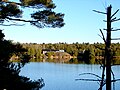
Municipal office in Lanark
Canada Southern Ontario location map 2.png
Red pog.svg
Lanark Highlands
Location in Southern Ontario
Coordinates: 45°05′17″N76°31′01″W / 45.088°N 76.517°W / 45.088; -76.517
Country Flag of Canada (Pantone).svg  Canada
Province Flag of Ontario.svg  Ontario
County Lanark
IncorporatedJuly 1, 1997
Government
  TypeTownship
  ReevePeter McLaren
  Governing BodyLanark Highlands Township Council
   MP Scott Reid  (CPC)
   MPP Randy Hillier  (OPC)
Area
[1]
  Land1,048.83 km2 (404.96 sq mi)
Population
 (2016) [2]
  Total5,338
  Density5.1/km2 (13/sq mi)
Time zone UTC-5 (EST)
  Summer (DST) UTC-4 (EDT)
Postal code
K0G 1K0
Area code(s) 613, 343
Website www.lanarkhighlands.ca

Lanark Highlands is a township in eastern Ontario, Canada in Lanark County. The township administrative offices are located in the village of Lanark.

Contents

History

The current township was incorporated on July 1, 1997 by amalgamating the former townships of Darling, Lanark, and the previously combined township Lavant, Dalhousie and North Sherbrooke with the village of Lanark.

Communities

The township comprises the communities of Arklan, Boyds, Brightside, Bullock, California, Cedardale, Clyde Forks, Clydesville, Dalhousie Lake, Elphin, Flower Station, Folger, French Line, Halls Mills, Halpenny, Hood, Hopetown, Joes Lake, Lammermoor, Lanark, Lavant, Lavant Station, Lloyd, Marble Bluff, McDonalds Corners, Middleville, Pine Grove, Poland, Quinn Settlement, Rosetta, Tatlock, Watsons Corners, and White, as well as the ghost town of Herrons Mills.

Demographics

In the 2021 Census of Population conducted by Statistics Canada, Lanark Highlands had a population of 5,737 living in 2,494 of its 3,409 total private dwellings, a change of 7.5% from its 2016 population of 5,338. With a land area of 1,031.52 km2 (398.27 sq mi), it had a population density of 5.6/km2 (14.4/sq mi) in 2021. [3]

Canada census – Lanark Highlands community profile
2021 2016 2011
Population5,737 (+7.5% from 2016)5,338 (+4.1% from 2011)5,128 (-1.0% from 2006)
Land area1,031.52 km2 (398.27 sq mi)1,048.83 km2 (404.96 sq mi)1,048.19 km2 (404.71 sq mi)
Population density5.6/km2 (15/sq mi)5.1/km2 (13/sq mi)4.9/km2 (13/sq mi)
Median age52.0 (M: 51.6, F: 52.4)51.2 (M: 51.1, F: 51.3)
Private dwellings3,409 (total)  2,494 (occupied)3,315 (total) 3,182 (total) 
Median household income$81,000$67,669
References: 2021 [4] 2016 [5] 2011 [6] earlier [7] [8]
Historical populations
YearPop.±%
2001 4,795    
2006 5,180+8.0%
2011 5,128−1.0%
2016 5,338+4.1%
[9] [1] [2]

Notable people

See also

Related Research Articles

<span class="mw-page-title-main">North Grenville</span> Municipality in Ontario, Canada

North Grenville is a township in eastern Ontario, Canada, in the United Counties of Leeds and Grenville on the Rideau River. It is located just south of Ottawa in Canada's National Capital Region.

<span class="mw-page-title-main">Montague, Ontario</span> Township in Ontario, Canada

Montague is a township in eastern Ontario, Canada, in Lanark County on the Rideau River. The township administrative offices are located on Roger Stevens Drive east of Smiths Falls.

<span class="mw-page-title-main">Beckwith, Ontario</span> Township in Ontario, Canada

Beckwith is a township in eastern Ontario, Canada. It is located in Lanark County on the Mississippi River. It is located within Canada's National Capital Region.

<span class="mw-page-title-main">Mississippi Mills, Ontario</span> Town in Ontario, Canada

Mississippi Mills is a town in eastern Ontario, Canada, in Lanark County on the Mississippi River. It is made up of the former Townships of Ramsay and Pakenham, as well as the Town of Almonte. It is partly located within Canada's National Capital Region.

<span class="mw-page-title-main">Champlain, Ontario</span> Township in Ontario, Canada

Champlain is a township in eastern Ontario, Canada, in the United Counties of Prescott and Russell on the Ottawa River. It was formed on January 1, 1998, through the amalgamation of West Hawkesbury Township, Longueuil Township, Town of Vankleek Hill, and the Village of L'Orignal.

<span class="mw-page-title-main">Renfrew County</span> County in Ontario, Canada

Renfrew County is a county in the Canadian province of Ontario. It stands on the west bank of the Ottawa River. There are 17 municipalities in the county.

<span class="mw-page-title-main">Lanark County</span> County in Ontario, Canada

Lanark County is a county located in the Canadian province of Ontario. Its county seat is Perth, which was first settled in 1816.

<span class="mw-page-title-main">Tay Valley, Ontario</span> Township in Ontario, Canada

Tay Valley is a township in eastern Ontario, Canada, on the Tay River in the southwest corner of Lanark County, adjacent to the United Counties of Leeds and Grenville and Frontenac County. The township administrative offices are located in Glen Tay.

<span class="mw-page-title-main">Black River-Matheson</span> Township in Ontario, Canada

Black River-Matheson is a township in the Cochrane District of the Canadian province of Ontario. The municipality is astride the Black River, for which it is partly named. The Matheson railway station was serviced by the Northlander until 2012.

<span class="mw-page-title-main">Mulmur</span> Township in Ontario, Canada

Mulmur is a township in Dufferin County in Southern Ontario, Canada. There are a number of original settlements such as Mulmur Corners, some of which can still be identified as to location, including Rosemont and Stanton.

<span class="mw-page-title-main">Hamilton Township, Ontario</span> Township in Ontario, Canada

Hamilton Township is a rural township located in Northumberland County in central Ontario. It surrounds the Town of Cobourg.

<span class="mw-page-title-main">Highlands East, Ontario</span> Township Municipality in Ontario, Canada

Highlands East is a township municipality located in Haliburton County, Ontario, Canada.

<span class="mw-page-title-main">Central Manitoulin</span> Township in Ontario, Canada

Central Manitoulin is a township in the Canadian province of Ontario. It is located on Manitoulin Island and in Manitoulin District.

<span class="mw-page-title-main">Tyendinaga, Ontario</span> Township in Ontario, Canada

Tyendinaga is a township in the Canadian province of Ontario, located in Hastings County. The community takes its name from a variant spelling of Mohawk leader Joseph Brant's traditional Mohawk name, Thayendanegea.

<span class="mw-page-title-main">Hastings Highlands</span> Municipality in Ontario, Canada

Hastings Highlands is a township in the Canadian province of Ontario.

<span class="mw-page-title-main">Rideau Lakes</span> Township in Ontario, Canada

Rideau Lakes is a township located within Leeds and Grenville United Counties in Eastern Ontario, Canada. The township was incorporated on 1 January 1998 by amalgamating the former townships of North Crosby, South Crosby, Bastard, South Burgess and South Elmsley with the village of Newboro.

<span class="mw-page-title-main">Melancthon, Ontario</span> Township in Ontario, Canada

Melancthon is a rural Canadian township in the northwest corner of Dufferin County, Ontario, bordered on the east by Mulmur Township, Amaranth Township and East Luther Grand Valley to the south, Southgate Township to the west, and the Municipality of Grey Highlands to the north. The township does not include the town of Shelburne on its southern border. It has one of the lowest population densities in southwestern Ontario.

<span class="mw-page-title-main">Southwest Middlesex, Ontario</span> Municipality in Ontario, Canada

Southwest Middlesex is a municipality in Middlesex County, Ontario, Canada.

<span class="mw-page-title-main">West Elgin, Ontario</span> Municipality in Ontario, Canada

West Elgin is a municipality in Elgin County, Ontario, Canada. The township was created on January 1, 1998, through the amalgamation of the former township of Aldborough with the village of West Lorne.

<span class="mw-page-title-main">Algonquin Highlands</span> Township in Ontario, Canada

Algonquin Highlands is a township located in Haliburton County, Ontario, Canada. It has a population of 2,351. The northeastern section of the township is included in Algonquin Provincial Park.

References

  1. 1 2 "Lanark Highlands census profile". 2011 Census of Population . Statistics Canada. Retrieved 2012-02-13.
  2. 1 2 "Census Profile, 2016 Census: Lanark Highlands, Township". Statistics Canada . Retrieved June 19, 2019.
  3. "Population and dwelling counts: Canada, provinces and territories, census divisions and census subdivisions (municipalities), Ontario". Statistics Canada. February 9, 2022. Retrieved April 2, 2022.
  4. "2021 Community Profiles". 2021 Canadian Census . Statistics Canada. February 4, 2022. Retrieved 2023-10-19.
  5. "2016 Community Profiles". 2016 Canadian Census . Statistics Canada. August 12, 2021. Retrieved 2019-06-19.
  6. "2011 Community Profiles". 2011 Canadian Census . Statistics Canada. March 21, 2019. Retrieved 2012-02-13.
  7. "2006 Community Profiles". 2006 Canadian Census . Statistics Canada. August 20, 2019.
  8. "2001 Community Profiles". 2001 Canadian Census . Statistics Canada. July 18, 2021.
  9. Statistics Canada: 1996, 2001, 2006 census