
Wyeville is a village in Monroe County, Wisconsin, United States. It is located on Wisconsin Highway 21. The population was 147 at the 2010 census.

Increase Allen Lapham was an author, scientist, and naturalist.
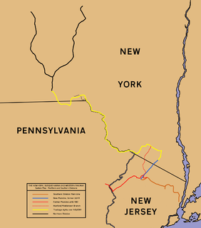
The New York, Susquehanna and Western Railway is a Class II American freight railway operating over 400 miles (645 km) of track in the northeastern U.S. states of New York, Pennsylvania, and New Jersey.

The Highland branch, also known as the Newton Highlands branch, was a suburban railway line in Boston, Massachusetts. It was opened by the Boston and Albany Railroad in 1886 to serve the growing community of Newton, Massachusetts. The line was closed in 1958 and sold to the Metropolitan Transit Authority (MTA), which reopened it in 1959 as a light rail line, now known as the D branch of the Green Line.

The Washington and Old Dominion Railroad was an intrastate short-line railroad located in Northern Virginia. The railroad was a successor to the bankrupt Washington and Old Dominion Railway and to several earlier railroads, the first of which began operating in 1859. The railroad closed in 1968.

The Chicago, St. Paul, Minneapolis and Omaha Railway or Omaha Road was a railroad in the U.S. states of Nebraska, Iowa, Minnesota, Wisconsin and South Dakota. It was incorporated in 1880 as a consolidation of the Chicago, St. Paul and Minneapolis Railway and the North Wisconsin Railway. The Chicago and North Western Railway (C&NW) gained control in 1882. The C&NW leased the Omaha Road in 1957 and merged the company into itself in 1972. Portions of the C. St. P. M. and O. are part of the Union Pacific Railroad network. This includes main lines from Wyeville, Wisconsin, to St. Paul, Minnesota, and St. Paul to Sioux City, Iowa.

The Great Falls and Old Dominion Railroad (GF&OD) was an interurban trolley line that ran in Northern Virginia during the early 20th century.

Rondout is an unincorporated community in Lake County, Illinois, United States that first formed around a railroad junction. The area is located within Libertyville Township. As Rondout is an unincorporated community rather than a municipality, it lacks clearly defined borders, and shares postal codes with Lake Bluff, Lake Forest and Libertyville, Illinois. It has its own elementary school which comes under Rondout School District 72. Illinois Route 176 passes east–west through Rondout, serving as the "main street" of the community, where it is also called "Rockland Road".

The Minneapolis, St. Paul and Sault Ste. Marie Railroad (MStP&SSM) was a Class I railroad subsidiary of the Canadian Pacific Railway in the Midwestern United States. Commonly known since its opening in 1884 as the Soo Line after the phonetic spelling of Sault, it was merged with several other major CP subsidiaries on January 1, 1961 to form the Soo Line Railroad.
The Gettysburg Railroad was a railway line in Pennsylvania that operated from 1858 to 1870 over the 17-mile (27 km) main line from the terminus in Gettysburg to the 1849 Hanover Junction. After becoming the Susquehanna, Gettysburg & Potomac Railway line in 1870, the tracks between Gettysburg and Hanover Junction became part of the Hanover Junction, Hanover and Gettysburg Railroad in 1874, the Baltimore and Harrisburg Railway in 1886, and the Western Maryland Railway in 1917.
The Chicago and St. Louis Railway was a predecessor of the Atchison, Topeka and Santa Fe Railway that owned a line between Chicago and Pekin, Illinois. More than half of the line is now part of the BNSF Railway's Southern Transcon.

Walsh is an unincorporated community located in the town of Porterfield, in Marinette County, Wisconsin, United States.

Minnesota Junction is an unincorporated community located, in the town of Oak Grove, in Dodge County, Wisconsin, United States. Minnesota Junction is located on Wisconsin Highway 26. It is located at latitude 43.452 and longitude -88.697 at 925 feet above mean sea level.

Valley Junction is an unincorporated community located in the Town of Byron in Monroe County, Wisconsin, United States. It is located at the intersection of Wisconsin Highway 173, Monroe County Trunk Highway G, and Monroe County Highway N.
Bagley Junction is an unincorporated community located in the town of Porterfield, Marinette County, Wisconsin, United States.
Stiles Junction is an unincorporated community located in the town of Stiles, Oconto County, Wisconsin, United States.
Ashland Junction is an unincorporated community located in the town of Eileen, Bayfield County, Wisconsin, United States.

The Northern Railroad was a U.S. railroad in central New Hampshire. Originally opened from Concord to West Lebanon in 1847, the Northern Railroad become part of the Boston and Maine system by 1890.
Valley was a populated place and post office on the South Branch line of the Baltimore and Ohio Railroad in the U.S. state of West Virginia. It was centered near the intersection of West Sioux Lane and Depot Valley Road, now located within the present-day corporate boundaries of Romney. Valley developed in 1884 following the completion of the South Branch line when the rail line's original southern terminus and corresponding Romney Depot were built there. The United States Post Office Department established a post office at Valley on May 19, 1928, remaining in operation until its disestablishment on June 15, 1937. Following the closure of Valley's post office, its mail was routed through the post office in Romney.
The Wisconsin & Michigan Railway (W&M) was incorporated October 26, 1893, under the general laws of Wisconsin for the purpose of constructing, maintaining, and operating a railroad as described in its articles of incorporation.


