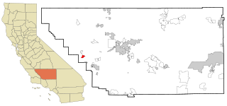
Derby Acres is a census-designated place (CDP) in Kern County, California, United States. Derby Acres is located 5.5 miles (8.9 km) north-northwest of Fellows, at an elevation of 1,375 feet (419 m). The population was 322 at the 2010 census, down from 376 at the 2000 census. The town is on State Route 33 at the northern extremity of the Midway-Sunset Oil Field, about five miles (8 km)five miles southeast of McKittrick.

Mashpee Neck is a census-designated place (CDP) in the town of Mashpee in Barnstable County, Massachusetts, United States. The population was 1,000 at the 2010 census. It is the most populous of the seven CDPs in Mashpee.

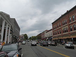
Housatonic is a census-designated place (CDP) in the town of Great Barrington in Berkshire County, Massachusetts, United States. It is part of the Pittsfield, Massachusetts Metropolitan Statistical Area. The population was 1,109 at the 2010 census. It was named after the Housatonic River.

Cochituate is a census-designated place (CDP) in the town of Wayland in Middlesex County, Massachusetts, United States. The population was 6,927 at the 2020 census, out of 13,943 in the entire town of Wayland.

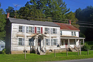
Marshfield Hills is a census-designated place (CDP) in the town of Marshfield in Plymouth County, Massachusetts, United States. The population was 2,356 at the 2010 census. The historic center of the village has been designated a historic district and listed on the National Register of Historic Places.

Baldwinville is an unincorporated village and census-designated place (CDP) in the town of Templeton in Worcester County, Massachusetts, United States. The population was 2,028 at the 2010 census. The name also refers to the local post office or railroad station.
Canaan is a town in Columbia County, New York, United States. The population was 1,570 at the 2020 census, down from 1,710 at the 2010 census. The town is in the northeastern part of the county.
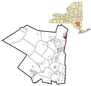
Glasco is a hamlet in Ulster County, New York, United States. The population was 2,013 at the 2020 census.

Rosemount is a census-designated place (CDP) in Clay Township, Scioto County, Ohio, United States. The population was 2,117 at the 2020 census.

Redwood is an unincorporated community and census-designated place (CDP) in Guadalupe County, Texas, United States. The population was 4,003 at the 2020 census, a decline from the figure of 4,338 tabulated in 2010. It is part of the San Antonio Metropolitan Statistical Area.

Adams is a census-designated place (CDP) located in the town of Adams in Berkshire County, Massachusetts, United States. The population was 5,515 at the 2010 census, out of 8,485 in the entire town of Adams.

Great Barrington is a census-designated place (CDP) located in the town of Great Barrington in Berkshire County, Massachusetts, United States. The population was 2,231 at the 2010 census, out of 7,104 in the entire town of Great Barrington.

Lenox, also known as Lenox Center, is a census-designated place (CDP) in the town of Lenox in Berkshire County, Massachusetts, United States. The population was 1,675 at the 2010 census, out of 5,025 in the entire town of Lenox.

Williamstown is a census-designated place (CDP) in the town of Williamstown in Berkshire County, Massachusetts, United States. The population of the CDP was 4,325 at the 2010 census, out of 7,754 in the entire town.

Rowley is a census-designated place (CDP) in the town of Rowley in Essex County, Massachusetts, United States. The population was 1,416 at the 2010 census.

Palmer is former census-designated place (CDP) in Hampden County, Massachusetts, United States. The population was 3,900 at the 2000 census. It is part of the Springfield, Massachusetts Metropolitan Statistical Area. The area is more commonly known as Depot Village, named for the ornate train depot built there by famed architect H.H. Richardson

Clinton is a census-designated place (CDP) in the town of Clinton in Worcester County, Massachusetts, United States. The population was 7,389 at the 2010 census.

Winchendon is a census-designated place (CDP) in the town of Winchendon in Worcester County, Massachusetts, United States. The population was 4,160 at the 2020 census.

Townsend is a census-designated place (CDP) comprising the main village in the town of Townsend in Middlesex County, Massachusetts, United States. The population was 1,213 at the 2020 census, out of 9,127 in the entire town.

Canaan is a village and census-designated place (CDP) within the town of North Canaan in Litchfield County, Connecticut, United States. Formerly known as Canaan Depot, the village is more commonly known as Canaan Village to distinguish it from the town of Canaan located to the south of North Canaan. The Canaan Village Historic District is listed on the National Register of Historic Places. As of the 2010 census, the CDP had a population of 1,212, out of a total population of 3,315 in the town of North Canaan.