
McCreary County is a county located in the U.S. state of Kentucky. As of the 2010 census, the population was 18,306. Its county seat is Whitley City. The county is named for James B. McCreary, a Confederate war hero and two-time Governor of Kentucky. During his second term as Governor, McCreary County was created by the Legislature and was named in his honor.
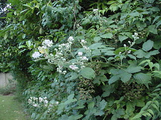
A bramble is any rough, tangled, prickly shrub, usually in the genus Rubus, the blackberries and raspberries and dewberries. "Bramble" is also used to describe other prickly shrubs such as roses. Bramble or brambleberry sometimes refers to the blackberry fruit or products of its fruit, such as bramble jelly.

The Cumberland River is a major waterway of the Southern United States. The 688-mile-long (1,107 km) river drains almost 18,000 square miles (47,000 km2) of southern Kentucky and north-central Tennessee. The river flows generally west from a source in the Appalachian Mountains to its confluence with the Ohio River near Paducah, Kentucky, and the mouth of the Tennessee River. Major tributaries include the Obey, Caney Fork, Stones, and Red rivers.

The Kentucky River is a tributary of the Ohio River, 260 miles (418 km) long, in the U.S. Commonwealth of Kentucky. The river and its tributaries drain much of the central region of the state, with its upper course passing through the coal-mining regions of the Cumberland Mountains, and its lower course passing through the Bluegrass region in the north central part of the state. Its watershed encompasses about 7,000 square miles (18,000 km2). It supplies drinking water to about one-sixth of the population of the Commonwealth of Kentucky.

The Red River, 100 miles (161 km) long, is a major stream of north-central Tennessee, United States and south-central Kentucky and a major tributary of the Cumberland River.

The Battle of Middle Creek was an engagement fought January 10, 1862, in Eastern Kentucky during the American Civil War.

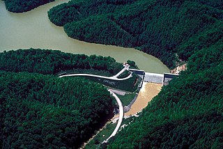
Carr Creek Lake, located east of Hazard, Kentucky, along Kentucky Route 15 in Knott County, is a 710 acres (3 km2) reservoir created by the U.S. Army Corps of Engineers in 1976. Carr Creek Lake's earth and rock fill dam is 130 ft (40 m) tall and 720 ft (219 m) long, and the dam is located 8.8 mi (14 km) above the mouth of Carr Fork River, a tributary of the North Fork Kentucky River.

The Big South Fork National River and Recreation Area preserves the Big South Fork of the Cumberland River and its tributaries in northeastern Tennessee and southeastern Kentucky. In addition, the former mining community of Blue Heron is preserved and interpreted via signage.

Strawberry Creek is the principal watercourse running through the city of Berkeley, California. Two forks rise in the Berkeley Hills of the California Coast Ranges, and form a confluence at the campus of the University of California, Berkeley. The creek then flows westward across the city to discharge into San Francisco Bay.

Breaks Interstate Park is a bi-state state park located partly in southeastern Kentucky and mostly in southwestern Virginia, in the Jefferson National Forest, at the northeastern terminus of Pine Mountain. Rather than their respective state park systems, it is instead administered by an interstate compact between the states of Virginia and Kentucky. It is one of several interstate parks in the United States, but only one of two operated jointly under a compact rather than as two separate state park units. The Virginia Department of Conservation and Recreation and the Kentucky Department of Parks are still major partner organizations, however.
Martins Fork Lake is a 340-acre (1.4 km2) reservoir in Harlan County, Kentucky. The lake was impounded from the Martin's Fork in 1979 by the United States Army Corps of Engineers. It is named for James Martin, an early pioneer in the area.

Blue Heron, also known as Mine 18, is a former coal mining community or coal town on the banks of the Big South Fork of the Cumberland River in McCreary County, Kentucky, United States, that has been recreated and is maintained as an interpretive history area in the Big South Fork National River and Recreation Area.
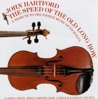
The Speed of the Old Long Bow is an album by John Hartford of traditional American fiddle music, released in 1998. It is a tribute to the legendary Kentucky/West Virginia old-time fiddler Blind Ed Haley.
Blackberry Creek is a stream in Pike County, Kentucky, in the United States. It is a tributary of the Tug Fork, part of the Big Sandy River and thus the Ohio River watershed.

Blackberry City is an unincorporated community in Mingo County, West Virginia, United States. Blackberry City is located on the Tug Fork and West Virginia Route 49 0.75 miles (1.21 km) south of Matewan. Blackberry City had a post office, which opened on September 2, 1949, and closed on March 17, 1984.
Right Fork of Long Fork is an unincorporated community located in Pike County, Kentucky, United States.
Kentucky Route 319 (KY 319) is a 6.9-mile-long (11.1 km) state highway in the U.S. state of Kentucky. The highway travels through mostly rural areas of Pike County.
Kentucky Route 404 (KY 404) is a 10.848-mile-long (17.458 km) state highway in the U.S. state of Kentucky. The highway connects mostly rural areas of Magoffin and Floyd counties with Prestonsburg.


