Lena, Mississippi

Last updated

Lena, Mississippi
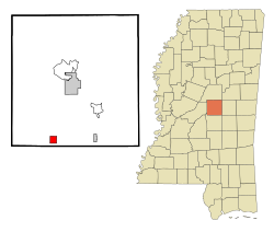
Leake County Mississippi Incorporated and Unincorporated areas Lena Highlighted.svg
Location of Lena, Mississippi
Usa edcp location map.svg
Red pog.svg
Lena, Mississippi
Location in the United States
USA Mississippi location map.svg
Red pog.svg
Lena, Mississippi
Lena, Mississippi (Mississippi)
Coordinates: 32°35′22″N89°35′41″W / 32.58944°N 89.59472°W / 32.58944; -89.59472
Country United States
State Mississippi
County Leake
Area
[1]
  Total1.66 sq mi (4.30 km2)
  Land1.66 sq mi (4.30 km2)
  Water0.00 sq mi (0.00 km2)
Elevation
344 ft (105 m)
Population
 (2020)
  Total157
  Density94.52/sq mi (36.49/km2)
Time zone UTC-6 (Central (CST))
  Summer (DST) UTC-5 (CDT)
ZIP code
39094
Area code 601
FIPS code 28-40360
GNIS feature ID0693710

Lena is a town in Leake County, Mississippi, United States. The population was 148 at the 2010 census. [2] The center of population of Mississippi is located in Lena. [3]

Contents

Geography

Lena is located in southwestern Leake County at 32°35′22″N89°35′41″W / 32.58944°N 89.59472°W / 32.58944; -89.59472 (32.589445, -89.594788). [4] It is 10 miles (16 km) southwest of Carthage, the county seat, and 40 miles (64 km) northeast from Jackson (straight line).

According to the United States Census Bureau, the town has a total area of 1.7 square miles (4.3 km2), all land. [5]

Demographics

Historical population
CensusPop.Note
1920 198
1930 432118.2%
1940 3,700756.5%
1950 4,73628.0%
1960 6,29532.9%
1970 233−96.3%
1980 231−0.9%
1990 175−24.2%
2000 167−4.6%
2010 148−11.4%
2020 1576.1%
U.S. Decennial Census [6]

As of the census [7] of 2000, there were 167 people, 77 households, and 48 families residing in the town. The population density was 99.3 inhabitants per square mile (38.3/km2). There were 96 housing units at an average density of 57.1 per square mile (22.0/km2). The racial makeup of the town was 90.42% White, 8.98% African American, and 0.60% from two or more races.

There were 77 households, out of which 23.4% had children under the age of 18 living with them, 54.5% were married couples living together, 3.9% had a female householder with no husband present, and 36.4% were non-families. 35.1% of all households were made up of individuals, and 24.7% had someone living alone who was 65 years of age or older. The average household size was 2.17 and the average family size was 2.76.

In the town, the population was spread out, with 21.6% under the age of 18, 6.0% from 18 to 24, 24.0% from 25 to 44, 28.7% from 45 to 64, and 19.8% who were 65 years of age or older. The median age was 44 years. For every 100 females, there were 87.6 males. For every 100 females age 18 and over, there were 79.5 males.

The median income for a household in the town was $36,250, and the median income for a family was $45,313. Males had a median income of $30,625 versus $20,625 for females. The per capita income for the town was $23,197. About 8.9% of families and 13.6% of the population were below the poverty line, including 13.8% of those under the age of eighteen and none of those 65 or over.

Education

The town is served by the Leake County School District.

Notable people

Related Research Articles

<span class="mw-page-title-main">Leake County, Mississippi</span> County in Mississippi, United States

Leake County is a county in the center of the U.S. state of Mississippi. As of the 2020 census, the population was 21,275. Its county seat is Carthage. The county is named for Walter Leake, the Governor of Mississippi from 1822 to 1825.

<span class="mw-page-title-main">Newbern, Alabama</span> Town in Alabama, United States

Newbern is a town in Hale County, Alabama, United States. As of the 2020 census, the population of the town was 133.

<span class="mw-page-title-main">Bassett, Arkansas</span> Town in Arkansas, United States

Bassett is a town in Mississippi County, Arkansas, United States. The population was 124 at the 2020 census, down from 173 in 2010.

<span class="mw-page-title-main">Eagle Lake, Maine</span> Town in the state of Maine, United States

Eagle Lake is a town in Aroostook County, Maine, United States. The population was 772 at the 2020 census. The town was named by a body of troops heading from Bangor to the Aroostook War for the many eagles that they saw around the lake. A total of 49.0% of the population speaks French, reflecting a trend in Northeastern Maine.

<span class="mw-page-title-main">Derma, Mississippi</span> Town in Mississippi, United States

Derma is a town in Calhoun County, Mississippi, United States. The population was 1,025 at the 2010 census.

<span class="mw-page-title-main">Goodman, Mississippi</span> Town in Mississippi, United States

Goodman is a town in southeastern Holmes County, Mississippi, United States. Per the 2020 census, the population was 1,258.

<span class="mw-page-title-main">Pickens, Mississippi</span> Town in Mississippi, United States

Pickens is a town in Holmes County, Mississippi, United States. Per the 2020 census, the population was 920.

<span class="mw-page-title-main">Louin, Mississippi</span> Town in Mississippi, United States

Louin is a town in Jasper County, Mississippi, United States, located along Mississippi Highway 15. The population was 277 at the 2010 census, down from 339 at the 2000 census. On June 18, 2023, the town was hit by a destructive EF3 tornado causing 1 death.

<span class="mw-page-title-main">Montrose, Mississippi</span> Town in Mississippi, United States

Montrose is a town in Jasper County, Mississippi, United States. The population was 140 at the 2010 census.

<span class="mw-page-title-main">Bassfield, Mississippi</span> Town in Mississippi, United States

Bassfield is a town in Jefferson Davis County, Mississippi, United States. The population was 192 at the 2020 census, down from 254 at the 2010 census.

<span class="mw-page-title-main">Redwater, Mississippi</span> Census-designated place in Mississippi, United States

Redwater is a census-designated place (CDP) in Leake County, Mississippi, United States. It is one of the eight communities of the Mississippi Band of Choctaw Indians Reservation, and the population is 61% Choctaw. The population was 633 at the 2010 census, up from 409 at the 2000 census.

<span class="mw-page-title-main">Standing Pine, Mississippi</span> Census-designated place in Mississippi, United States

Standing Pine is a census-designated place (CDP) in Leake County, Mississippi, United States. It is one of the eight communities of the Mississippi Band of Choctaw Indians Reservation, and the population is 94% Choctaw. The total population of the CDP was 517 at the 2020 census.

<span class="mw-page-title-main">Decatur, Mississippi</span> Town in Mississippi, United States

Decatur is a town in and the county seat of Newton County, Mississippi. The population was 1,841 at the 2010 census. This town is named after war hero Stephen Decatur, Jr.

<span class="mw-page-title-main">Courtland, Mississippi</span> Town in Mississippi, United States

Courtland is a town in Panola County, Mississippi. The population was 511 at the time of the 2010 census.

<span class="mw-page-title-main">Polkville, Mississippi</span> Town in Mississippi, United States

Polkville is a town in Smith County, Mississippi. The population is at 833 as of the 2010 census.

<span class="mw-page-title-main">Noxapater, Mississippi</span> Town in Mississippi, United States

Noxapater is a town in Winston County, Mississippi. The population was 472 at the 2010 census.

<span class="mw-page-title-main">West Liberty, West Virginia</span> Town in West Virginia, United States

West Liberty is a town in Ohio County, West Virginia, United States. The population was 1,557 at the 2020 census. It is part of the Wheeling metropolitan area.

<span class="mw-page-title-main">Fort Gay, West Virginia</span> Town in West Virginia, United States

Fort Gay is a town in Wayne County, West Virginia, United States, situated along the Tug Fork and Big Sandy rivers. The town adjoins Louisa, Kentucky. The population was 677 at the 2020 census.

<span class="mw-page-title-main">Union, Mississippi</span> Town in Mississippi, United States

Union is a town in Neshoba and Newton counties, Mississippi. The population was 1,988 at the 2010 census.

<span class="mw-page-title-main">Lake, Mississippi</span> Town in Mississippi, United States

Lake is a town in Newton and Scott counties, Mississippi. The population was 408 at the 2000 census.

References

  1. "2020 U.S. Gazetteer Files". United States Census Bureau. Retrieved July 24, 2022.
  2. "Total Population: 2010 Census DEC Summary File 1 (P1), Lena town, Mississippi". data.census.gov. U.S. Census Bureau. Retrieved April 3, 2020.
  3. "Population and Population Centers by State: 2000". U.S. Census Bureau. Archived from the original on September 18, 2008. Retrieved April 3, 2020.
  4. "US Gazetteer files: 2010, 2000, and 1990". United States Census Bureau. February 12, 2011. Retrieved April 23, 2011.
  5. "U.S. Gazetteer Files: 2019: Places: Mississippi". U.S. Census Bureau Geography Division. Retrieved April 3, 2020.
  6. "Census of Population and Housing". Census.gov. Retrieved June 4, 2015.
  7. "U.S. Census website". United States Census Bureau . Retrieved January 31, 2008.
  8. "Beeman, Joseph Henry". Biographical Directory of the United States Congress. Retrieved January 14, 2023.