Harvard Square is a triangular plaza at the intersection of Massachusetts Avenue, Brattle Street and John F. Kennedy Street near the center of Cambridge, Massachusetts, United States. The term "Harvard Square" is also used to delineate the business district and Harvard University surrounding that intersection, which is the historic center of Cambridge. Adjacent to Harvard Yard, the historic heart of Harvard University, the Square functions as a commercial center for Harvard students, as well as residents of western Cambridge, the western and northern neighborhoods and the inner suburbs of Boston. The Square is served by Harvard station, a major MBTA Red Line subway and a bus transportation hub.

The Old South Meeting House is a historic Congregational church building located at the corner of Milk and Washington Streets in the Downtown Crossing area of Boston, Massachusetts, built in 1729. It gained fame as the organizing point for the Boston Tea Party on December 16, 1773. Five thousand or more colonists gathered at the Meeting House, the largest building in Boston at the time.

The Old State House a/k/a the Old Provincial State House, is a historic building in Boston, Massachusetts, built in 1713. It was the seat of the Massachusetts General Court until 1798. It is located at the intersection of Washington and State Streets and is one of the oldest public buildings in the United States.

The Liberty Tree (1646–1775) was a famous elm tree that stood in Boston, Massachusetts near Boston Common in the years before the American Revolution. In 1765, Patriots in Boston staged the first act of defiance against the British government at the tree. The tree became a rallying point for the growing resistance to the rule of Britain over the American colonies, and the ground surrounding it became known as Liberty Hall. The Liberty Tree was felled in August 1775 by Loyalists led by Nathaniel Coffin Jr. or by Job Williams.

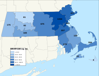
The National Register of Historic Places is a United States federal official list of places and sites considered worthy of preservation. In the state of Massachusetts, there are over 4,300 listings, representing about 5% of all NRHP listings nationwide and the second-most of any U.S. state, behind only New York. Listings appear in all 14 Massachusetts counties.

The Old Corner Bookstore is a historic commercial building located at 283 Washington Street at the corner of School Street in the historic core of Boston, Massachusetts. It was built in 1718 as a residence and apothecary shop, and first became a bookstore in 1828. The building is a designated site on Boston's Freedom Trail, Literary Trail, and Women's Heritage Trail.

The West Newton Village Center Historic District encompasses the heart of the village of West Newton, in the city of Newton, Massachusetts in the United States. It extends along Washington Street between Lucas Court in the west and Davis Court in the east, and includes a few properties on immediately adjacent side streets, including Watertown Street and Waltham Street. The village is the second-largest of Newton's commercial centers and is the best-preserved of its late 19th and early 20th century village centers. The district was listed on the National Register of Historic Places in 1990.

The East End Historic District in Newburgh, New York, United States is the lower portion of what state and city officials recognize as a single historic district along with the Montgomery-Grand-Liberty Streets Historic District. Its 445 acres (2 km2) contain 2,217 buildings, including Washington's Headquarters State Historic Site, a National Historic Landmark.

Filene's Department Store was a department store building at 426 Washington Street in Downtown Crossing, Boston, Massachusetts. It was the flagship store of the Filene's department store chain. The building has been renovated and now serves as the offices for Havas and Arnold Worldwide. The building is maintained as part of the Millennium Tower. It is now home to fast fashion retailer, Primark.

The Blackstone Block Historic District encompasses what was once a waterfront business area in Boston, Massachusetts. Due to the infill of land it is now slightly inland from the waterfront. The district is bounded by Union, Hanover, Blackstone, and North Streets, not far from Quincy Market and Faneuil Hall. It includes the Union Oyster House, a National Historic Landmark building erected in the 1710s, and a collection of commercial buildings dating from the late 18th and 19th centuries. The district was added to the National Register of Historic Places in 1973. It also includes the c. 1770s Ebenezer Hancock House, a Federal-style wood-frame house that is the only building left in the city which was known to be owned by John Hancock. The building was designated a Boston Landmark by the Boston Landmarks Commission in 1978 for its notable exterior and interiors. In 1983, the surrounding ca. 1676 Blackstone Block Street Network was also designated by the Boston Landmarks Commission.

The Codman Square District is a historic district in the Dorchester neighborhood of Boston, Massachusetts. It consists of four of the most prominent properties facing the main Codman Square intersection, where Talbot Avenue and Washington Street cross. The area has a long history as a major civic center in Dorchester, and is now one of the large neighborhood's major commercial hubs. The properties in the district include the 1806 Congregational Church, the 1904 Codman Square branch of the Boston Public Library, the former Girls Latin Academy building, and the Lithgow Building, a commercial brick structure at the southeast corner of the junction that was built in 1899.

Custom House District is a historic district in Boston, Massachusetts, located between the Fitzgerald Expressway and Kilby Street and South Market and High and Batterymarch Streets. Named after the 1849 Boston Custom House located on State Street, the historic district contains about seventy buildings on nearly sixteen acres in Downtown Boston, consisting of 19th-century mercantile buildings along with many early 20th-century skyscrapers, including the 1915 Custom House Tower.

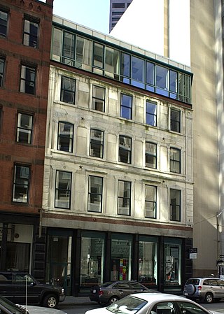
The Richardson Block is a historic block of commercial buildings at 113-151 Pearl and 109-119 High Streets in Boston, Massachusetts. It consists of a series of buildings constructed in the aftermath of the Great Boston Fire of 1872. The first of these buildings, at the corner of Pearl and High Streets, was designed by William Preston and built in 1873 for Jeffrey Richardson, using granite and brick salvaged from buildings that had previously stood on the site. The area was an important locus of the leather goods business both before and after the fire, and the buildings constructed after the fire are among the only neo-Greek commercial structures standing in Boston's Financial District.

The Taunton Green Historic District encompasses the core area of the historic 19th-century commercial downtown business district of Taunton, Massachusetts. It is centered on the town green, laid out in the 1740s, which now serves at the intersection between U.S. Route 44, Massachusetts Route 140, and Route 138. The district was listed on the National Register of Historic Places in 1985.

The North High Street Historic District is a historic district encompassing part of the downtown area of Holyoke, Massachusetts. When first added to the National Register of Historic Places in 1986, the district encompassed North High Street, between Dwight and Lyman Streets. This part of High Street was built between 1850 and 1885, and is lined with masonry buildings in Italianate and Second Empire styles. In 1992 the district was extended southward, adding three blocks of High Street between Dwight and Essex Streets. This expansions encompasses the growth of Holyoke during the height of its commercial success, between 1880 and 1930; it also includes the separately-listed Holyoke City Hall. The district was extended a third time, in 2008, adding a complex of three buildings at Dwight and Maple Streets that now houses the Holyoke Health Center.

The Essex Institute Historic District is a historic district at 134-132, 128, 126 Essex Street and 13 Washington Square West in Salem, Massachusetts. It consists of a compact group of properties associated with the Essex Institute, founded in 1848 and merged in 1992 into the Peabody Essex Museum. Listed by increasing street number, they are: the Crowninshield-Bentley House, the Gardner-Pingree House, the John Tucker Daland House, and the Phillips Library. The John Ward House, which fronts on Brown Street but shares the 132 Essex Street address, is another National Historic Landmark within the district. The Andrew Safford House at 13 Washington Square West, built in 1819, was said to be the most expensive home in New England at the time.

Salem Common Historic District is a historic district bounded roughly by Bridge, Derby, and St. Peter's streets, as well as Collins Cove in Salem, Massachusetts, United States.

This is a list of the National Register of Historic Places listings in Lynn, Massachusetts.

The Mount Vernon Triangle Historic District is a historic district in the Mount Vernon Triangle neighborhood of Washington, D.C., consisting of 22 contributing residential, commercial, and industrial buildings, and one known archaeological site. The area was once a working class neighborhood for mostly German immigrants and home to semi-industrial enterprises such as a dairy and an automobile repair shop. The Northern Liberty Market that once stood on the corner of 5th Street and K Street NW played a large role in spurring development in the surrounding area as did the streetcars on Massachusetts Avenue and New York Avenue.

The Sarah Davidson Apartment Block is a historic commercial and multifamily residential building at 3 Gaylord Street in the Dorchester neighborhood of Boston, Massachusetts. The three-story brick, sandstone and copper Classical Revival building was constructed in 1901 to a design by A. B. Pinkham. The building, located at the corner of Gaylord and Washington Streets, has three commercial storefronts facing Washington Street, which are separated by sandstone piers. The residential entrance lies on Gaylord Street recessed in a rounded sandstone archway. The exterior of the upper floors consists of protruding sections finished in pressed copper, including a rounded corner section, and sections of brick. A heavy denticulated copper cornice overhangs both street-facing facades.


