Hingham is a town in metropolitan Greater Boston on the South Shore of the U.S. state of Massachusetts in northern Plymouth County. At the 2020 census, the population was 24,284. Hingham is known for its colonial history and location on Boston Harbor. The town was named after Hingham, Norfolk, England, and was first settled by English colonists in 1633.
The Boston Harbor Islands National Recreation Area is a national recreation area situated among the islands of Boston Harbor of Boston, Massachusetts. The area is made up of a collection of islands, together with a former island and a peninsula, many of which are open for public recreation and some of which are very small and best suited for wildlife. The area is run by the Boston Harbor Islands Partnership. It includes the Boston Harbor Islands State Park, managed by the Commonwealth of Massachusetts. Twenty-one of the 34 islands in the area are also included in the Boston Harbor Islands Archeological District.

Massachusetts Avenue is a major diagonal transverse road in Washington, D.C., and the Massachusetts Avenue Historic District is a historic district that includes part of it.

Ashland Park is a historic early 20th century neighborhood in Lexington, Kentucky, United States. It was named after Ashland, the estate of Kentucky statesman Henry Clay which is located in the eastern portion of the neighborhood. The 600-acre (2.4 km2) development was designed by the famous landscape architecture firm the Olmsted Brothers of Massachusetts. The neighborhood belongs to the National Register of Historic Places.

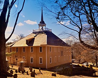
The Old Ship Church is a Puritan church built in 1681 in Hingham, Massachusetts. It is the only surviving 17th-century Puritan meetinghouse in America. Its congregation, gathered in 1635 and officially known as First Parish in Hingham, occupies the oldest church building in continuous ecclesiastical use in the United States. On October 9, 1960, it was designated a National Historic Landmark and on November 15, 1966, it was added to the National Register of Historic Places.

The General Benjamin Lincoln House is a National Historic Landmark at 181 North Street in Hingham, Massachusetts, United States. It was the birthplace and principal residence of Continental Army Major General Benjamin Lincoln (1733–1810), a well-respected military leader of the American Revolutionary War. The house has portions that are said to date to the 1630s, with significant additions made principally during the 18th century, possibly making it one of the nation's oldest wood-frame buildings. The last major modifications to the house were probably undertaken by General Lincoln in the late 18th century.

The North Easton Historic District is a historic district in Easton, Massachusetts encompassing a cohesive village area developed in the late 19th and early 20th centuries, primarily through the activities of the locally important Ames family. The district was added to the National Register of Historic Places in 1972. In 1987, a portion of the district was designated a National Historic Landmark District, known as the H. H. Richardson Historic District of North Easton, which includes several buildings designed for the Ameses by architect H. H. Richardson.

The Acushnet Heights Historic District is a predominantly residential historic district in central New Bedford, Massachusetts. It encompasses a densely-built urban area about 20 acres (8.1 ha) in size, which was developed as a working-class area, beginning in the 1860s, for the many workers in the city's factories. The district was listed on the National Register of Historic Places in 1989. It abuts the North Bedford Historic District, which is just to the south, and includes the following separately-listed properties: the Union Street Railway Carbarn, the Bradford Smith Building, and the Dawson Building.

The Cushing Homestead is a historic house at 210 East Street in Hingham, Massachusetts. The home is a 2+1⁄2-story rear saltbox, and has traces of both 17th-century English style as well as later 18th-century Georgian. The two rooms that originally made up the house look much today as they likely did before the house was later enlarged.

The South Hingham Historic District is a historic district roughly along Main St., from Cushing St. to Tower Brook Road in Hingham, Massachusetts. This area of Main Street is predominantly residential, and is distinctive for its boulevard-like character, which was envisioned in town planning documents as early as the late 17th century. A significant feature of the area is the presence of conservation land behind the properties on much of this stretch of Main Street, which has effectively throttled large-scale development. These properties include the Jacob Meadow, Mildred Cushing Woods, and Crooked Meadow River Area. The oldest structure in the district is the 1650 Edward Wilder House at 597 Main Street.

Hull Shore Drive and Nantasket Avenue are a historic coastal parkway in Hull, Massachusetts. Nantasket Avenue, designated as part of Route 228, is the main road through the town of Hull. Hull Shore Drive is a short segment of the road, near the Nantasket Beach Reservation at the southern end of the Hull peninsula. A 1.25-mile (2.01 km) section of the roads was added to the National Register of Historic Places in 2004.

The Hadley Center Historic District is an expansive, 2,500-acre (1,000 ha) historic district encompassing the village center of Hadley, Massachusetts. When it was first listed on the National Register of Historic Places in 1977, the district encompassed the town green and 17 buildings that faced it, at the junction of Russell Street and Middle Street. The district was expanded significantly in 1994, adding more than 400 buildings representative of the village's growth from colonial days into the first decades of the 20th century. This expansion encompasses the entirety of a tongue of land extending west from East Street and bounded by a bend in the Connecticut River, which separates Hadley from Northampton. Its oldest property, the Samuel Porter House on West Street, was built in 1713.

The East End Historic District encompasses the historic eastern portion of central Ipswich, Massachusetts. The now predominantly residential district is bounded on the north and west by East Street, running from its junction with North Main and High Streets to Jeffrey's Neck Road. The eastern boundary includes the Ipswich River and Turkey Shore Road from its junction with Labor-in-Vain Road to Green Street, and the southern boundary runs along Green Street to North Main. The district was listed on the National Register of Historic Places in 1980.

The Marlborough Center Historic District is a historic district encompassing the civic and commercial heart of Marlborough, Massachusetts. It is centered on a stretch of Main Street between Lincoln Street in the west and Bolton Street in the east, and includes properties on adjacent streets. The center is reflective of the city's prosperity as an industrial center from the mid-19th century to the mid-20th century. The district was listed on the National Register of Historic Places in 1998.

The Nobility Hill Historic District is a residential historic district roughly bounded by Chestnut and Maple Streets and Cedar Avenue in Stoneham, Massachusetts. The district includes a number of high quality houses representing a cross section of fashionable housing built between 1860 and 1920. It was added to the National Register of Historic Places in 1990.

The Front Street Historic District in Exeter, New Hampshire, encompasses a portion of the town's historic center. The district extends from Swasey Pavilion, at the junction of Front and Water streets, southwesterly along Front Street to Gale Park, about five blocks. Front Street is one of Exeter's oldest roads, and is lined with a series of 18th and 19th-century civic, religious, and residential structures, many of which are well preserved. The district was listed on the National Register of Historic Places (NRHP) in 1973.

Kilham & Hopkins was an architectural firm in Boston, Massachusetts formed in 1899 or 1900 by its founding members, Walter Harrington Kilham and James Cleveland Hopkins. The firm later became Kilham, Hopkins & Greeley after William Roger Greeley joined the firm in 1916, and Kilham Hopkins Greeley and Brodie after Walter S. (Steve) Brodie joined the firm in 1945.

The Jewell Town District of South Hampton, New Hampshire, encompasses a colonial-era industrial village with a history dating to 1687. It is centered at the junction of West Whitehall and Jewell Streets, which is just south of a bend in the Powwow River, the source of the power for the mills that were built here. The area was settled in 1687 by Thomas Jewell, and by the early 19th century included a variety of mills as well as a bog iron works. The district now includes only remnants of its industrial past, and features a collection of 18th and early-19th century residential architecture. The district was listed on the National Register of Historic Places in 1983.

The Town Center Historic District encompasses the historic village center of South Hampton, New Hampshire. Centered around the Barnard Green, the town common, on New Hampshire Route 107A, it includes architectural reminders of the town's growth and change over time. The district was listed on the National Register of Historic Places in 1983.
The Federal Street Historic District of Brunswick, Maine encompasses a part of the town whose development was influenced by its 18th-century success as a shipping center, and by the presence of Bowdoin College, whose historic central campus is part of the district. In addition to the campus, the district includes a series of relatively high-style Federal and later-period houses along Federal Street and Maine Street, which join the campus to downtown Brunswick. The district was listed on the National Register of Historic Places in 1976.


