
Brookline is a town in Norfolk County, Massachusetts, United States, and part of the Boston metropolitan area. An exclave of Norfolk County, Brookline borders six of Boston's neighborhoods: Brighton, Allston, Fenway–Kenmore, Mission Hill, Jamaica Plain, and West Roxbury. The city of Newton borders Brookline to the west. It is known as the birthplace of John F. Kennedy.

Chestnut Hill is a wealthy New England village located six miles (10 km) west of downtown Boston, Massachusetts, United States. It is best known for being home to Boston College and a section of the Boston Marathon route. Like all Massachusetts villages, Chestnut Hill is not an incorporated municipal entity. It is located partially in Brookline in Norfolk County; partially in the city of Boston in Suffolk County, and partially in the city of Newton in Middlesex County. Chestnut Hill's borders are defined by the 02467 ZIP Code. The name refers to several small hills that overlook the 135-acre Chestnut Hill Reservoir rather than one particular hill.

Thomas Aspinwall Davis was a silversmith and businessman who served as mayor of Boston for nine months in 1845.
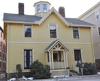
The Thomas Aspinwall Davis House is a historic house at 29 Linden Place in Brookline, Massachusetts. The house was built in 1844, by Thomas Aspinwall Davis, later a mayor of Boston, and is one of the earliest buildings to survive from his Linden Park project, the first residential subdivision in Brookline. The house was listed on the National Register of Historic Places in 1985.

The Harvard Avenue Historic District is a historic district roughly bounded by Linden Street, Commonwealth Avenue, Harvard Avenue, and Park Vale Avenue in the Allston neighborhood of Boston, Massachusetts. Its spine is Harvard Avenue, a major north–south thoroughfare connecting Allston to points north, and south toward Brookline. The area underwent a population explosion in the early 20th century, and Harvard Avenue was developed roughly between 1905 and 1925 as a commercial and residential spine. Notable buildings in the district include the Allston Station building, designed by Shepley, Rutan and Coolidge, and the Harvard Avenue Fire Station.
The Crystal Lake and Pleasant Street Historic District encompasses a streetcar suburban residential subdivision developed between 1860 and 1895 in Newton, Massachusetts. The district roughly bounded by the Sudbury Aqueduct, Pleasant Street, Lake Avenue, Webster Court, and Crystal Street. The subdivision was laid out in the 1850s after the Boston and Charles Railroad line was extended through Newton from Brookline. The district was listed on the National Register of Historic Places in 1986.
The William Ingersoll Bowditch House is a historic house at 9 Toxteth Street in Brookline, Massachusetts. It is a good example of vernacular Gothic and Greek Revival architecture, built c. 1844-45 as part of one of Brookline's earliest formal residential subdivisions. William Bowditch, the first owner, was an active abolitionist who sheltered fugitive slaves as part of the Underground Railroad, and was a member of the Boston Vigilance Committee. The house was listed on the National Register of Historic Places on October 17, 1985.

The Brookline Town Green Historic District encompasses the historic colonial heart of the town of Brookline, Massachusetts. Centered on a stretch of Walnut Street between Warren and Chestnut Streets, this area is where the town's first colonial meeting house and cemetery were laid out, and was its center of civic life until the early 19th century. The district was listed on the National Register of Historic Places in 1980.

The Cypress–Emerson Historic District encompasses a residential area on the west side of Brookline Village in Brookline, Massachusetts, United States. Centered on Waverly and Cypress Streets, and including Emerson Park, this area was developed in the post-Civil War era, its growth matching that of the commercial areas of the village. The district was listed on the National Register of Historic Places in 1985.

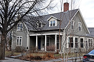
The Robert S. Davis House is a historic house at 50 Stanton Road in Brookline, Massachusetts. Built about 1859 for the scion of a locally prominent family, it is one of the town's best-preserved examples of Italianate architecture. It was listed on the National Register of Historic Places in 1985.

The Fisher Hill Historic District encompasses a residential area in central Brookline, Massachusetts. The area was subdivided and built out beginning in the 1880s, with landscaping design by Frederick Law Olmsted and John Charles Olmsted. The district is bounded on the west by Chestnut Hill Avenue, Baxter Road, and Channing Road, and on the south by Massachusetts Route 9. Its eastern boundary runs along Buckminster Street to Dean Road, joining the northern boundary of Clinton Road, running between Dean Road and Chestnut Hill Avenue. Prior to its development in the 1880s, Fisher Hill had a relatively small number of landowners. Some of them banded together, hiring the Olmsteds to design a subdivision plan for the entire district. Lots were sold to wealthy individuals, who built fashionable houses, often designed by architects. In 1914 a restrictive covenant was entered into by a significant number of property owners, restricting their properties to strictly single-family residential uses.
The Graffam Development Historic District is a residential area located in the American town of Brookline, Massachusetts. It encompasses the best-preserved portion of a historic residential subdivision, platted and built between 1894 and 1907. The land was purchased by Peter Graffam, who built a variety of Queen Anne and Colonial Revival houses on Babcock Street, Abbottsford Road, Manchester Road, Stedman Street, and Naples Road in Brookline, Massachusetts. Graffam also developed Osborne Street, but most of its houses have since been modified, losing historic integrity. The district was listed on the National Register of Historic Places in 1985.

Hammond Pond Parkway is a historic parkway in Chestnut Hill, Massachusetts. The road, built in 1932, extends 2 miles (3.2 km) from Hobart Road in Newton to Horace James Circle in Brookline, where it joins the West Roxbury Parkway. It was designed by Charles Eliot and the Olmsted Brothers to provide a parkway setting that provided access from Brookline, Newton, and the western portions of Boston to the southern parks of the Emerald Necklace. The parkway was listed on the National Register of Historic Places in 2004.

12 Linden Street is a historic house located in Brookline, Massachusetts. It is a rare local example of Greek Revival styling, and one of a few houses to survive from the residential development of the Linden Street area in the 1840s.

19 Linden Street is a historic house located in Brookline, Massachusetts. It is a well-preserved local example of Greek Revival styling, and the best-preserved survivor of a residential subdivision developed in the 1840s.

The House at 9 Linden Street in Brookline, Massachusetts, USA, is a locally rare example of transitional Greek Revival and Italianate styling, and one of the few surviving houses from the original development of the Linden Street area in the 1840s. The 2+1⁄2-story wood-frame house was built in 1843 for Isaac Rich, a partner in a successful merchant firm and a co-founder of Boston University. The house's mansard roof is a later addition, probably dating to the 1860s.

Linden Square is a small municipal park at Linden Place in Brookline, Massachusetts, United States. Roughly rectangular in shape with one curved side, Linden Square was laid out in 1844 by Alexander Wadsworth as part of the subdivision of the area by Thomas Aspinwall Davis. Its original pathways consisted of a horseshoe-shaped path flanking its perimeter, and a straight path that bisected the park; it now has paths that form an X, a layout adopted by the late 19th century. The park consists of grassy areas dotted with trees, and surrounded by a wrought iron fence with openings for the paths.

The Pill Hill Historic District is a historic district roughly bounded by Boylston Street, Pond Ave., and Acron, Oakland and Highland Roads in Brookline, Massachusetts.

Saint Mary of the Assumption Church, Rectory, School and Convent is a historic church complex at 67 Harvard Street, and 3 and 5 Linden Place, in Brookline, Massachusetts in the Archdiocese of Boston. It was the first Roman Catholic Church in Brookline, and the first in the nation to bear the name. Most of its buildings were built between 1880 and 1906, and are reflective of the growth of the area's Irish immigrant community during that time. The complex was listed on the National Register of Historic Places in 1985.

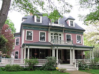
The Longwood Historic District is roughly bounded by Chapel, St. Marys, Monmouth, and Kent Sts. in Brookline, Massachusetts. The area was developed in the mid-19th century by David Sears and Amos Adams Lawrence as a fashionable residential area, and retains a number of architecturally distinguished buildings, including the Longwood Towers complex at 20 Chapel Street, Christ's Church Longwood, and Church of Our Saviour, Brookline. The district was listed on the National Register of Historic Places on September 13, 1978.


