
Chestnut Hill is a wealthy New England village located six miles (10 km) west of downtown Boston, Massachusetts, United States. It is best known for being home to Boston College and a section of the Boston Marathon route. Like all Massachusetts villages, Chestnut Hill is not an incorporated municipal entity. It is located partially in Brookline in Norfolk County; partially in the city of Boston in Suffolk County, and partially in the city of Newton in Middlesex County. Chestnut Hill's borders are defined by the 02467 ZIP Code. The name refers to several small hills that overlook the 135-acre Chestnut Hill Reservoir rather than one particular hill.

The Emerald Necklace consists of a 1,100-acre chain of parks linked by parkways and waterways in Boston and Brookline, Massachusetts. It was designed by landscape architect Frederick Law Olmsted, and gets its name from the way the planned chain appears to hang from the "neck" of the Boston peninsula. In 1989, the Emerald Necklace was designated as a Boston Landmark by the Boston Landmarks Commission.
The Thomas Aspinwall Davis House is a historic house at 29 Linden Place in Brookline, Massachusetts. The house was built in 1844, by Thomas Aspinwall Davis, later a mayor of Boston, and is one of the earliest buildings to survive from his Linden Park project, the first residential subdivision in Brookline. The house was listed on the National Register of Historic Places in 1985.

The Harvard Avenue Historic District is a historic district roughly bounded by Linden Street, Commonwealth Avenue, Harvard Avenue, and Park Vale Avenue in the Allston neighborhood of Boston, Massachusetts. Its spine is Harvard Avenue, a major north–south thoroughfare connecting Allston to points north, and south toward Brookline. The area underwent a population explosion in the early 20th century, and Harvard Avenue was developed roughly between 1905 and 1925 as a commercial and residential spine. Notable buildings in the district include the Allston Station building, designed by Shepley, Rutan and Coolidge, and the Harvard Avenue Fire Station.

St. Mark's Methodist Church is a historic church building at 90 Park Street in Brookline, Massachusetts. The church cornerstone was laid on April 9, 1892. The building was designed by Brookline architect George A. Clough in a Romanesque style. The building, vacated by its dwindling congregation in 1968, was listed on the National Register of Historic Places in 1976. It has since been converted into condominiums.
The Beacon Street Historic District is a historic district running most of the length of Beacon Street in Brookline, Massachusetts, roughly from Saint Mary's Road, near Kenmore Square, to Ayr Road near Cleveland Circle. It includes a small number of properties on adjacent streets, and was listed on the National Register of Historic Places in 1985.
The William Ingersoll Bowditch House is a historic house at 9 Toxteth Street in Brookline, Massachusetts. It is a good example of vernacular Gothic and Greek Revival architecture, built c. 1844-45 as part of one of Brookline's earliest formal residential subdivisions. William Bowditch, the first owner, was an active abolitionist who sheltered fugitive slaves as part of the Underground Railroad, and was a member of the Boston Vigilance Committee. The house was listed on the National Register of Historic Places on October 17, 1985.

The Brookline Town Green Historic District encompasses the historic colonial heart of the town of Brookline, Massachusetts. Centered on a stretch of Walnut Street between Warren and Chestnut Streets, this area is where the town's first colonial meeting house and cemetery were laid out, and was its center of civic life until the early 19th century. The district was listed on the National Register of Historic Places in 1980.

Brookline Village is one of the major commercial and retail centers of the town of Brookline, Massachusetts, United States. Located just north of Massachusetts Route 9 and west of the Muddy River, it is the historic center of the town and includes its major civic buildings, including town hall and the public library. The commercial spine of the village, extending along Washington Street from Route 9 to the library, is a historic district listed on the National Register of Historic Places as the Brookline Village Commercial District.

Hammond Pond Parkway is a historic parkway in Chestnut Hill, Massachusetts. The road, built in 1932, extends 2 miles (3.2 km) from Hobart Road in Newton to Horace James Circle in Brookline, where it joins the West Roxbury Parkway. It was designed by Charles Eliot and the Olmsted Brothers to provide a parkway setting that provided access from Brookline, Newton, and the western portions of Boston to the southern parks of the Emerald Necklace. The parkway was listed on the National Register of Historic Places in 2004.

12 Linden Street is a historic house located in Brookline, Massachusetts. It is a rare local example of Greek Revival styling, and one of a few houses to survive from the residential development of the Linden Street area in the 1840s.

19 Linden Street is a historic house located in Brookline, Massachusetts. It is a well-preserved local example of Greek Revival styling, and the best-preserved survivor of a residential subdivision developed in the 1840s.

4 Perry Street is a historic house in Brookline, Massachusetts, USA. It is locally significant as a well-preserved local example of Greek Revival styling.

The House at 44 Linden Street in Brookline, Massachusetts, is a little-altered local example of Second Empire styling. The 1+1⁄2-story house was built in 1874 by Solomon Eaton on land that was owned for many years by Thomas Aspinwall Davis. It has classic Second Empire features, including a mansard roof, polygonal bay windows, and brownstone window arches. The only significant alteration is a sunporch on the left side. It was converted into a two-family in 1923.

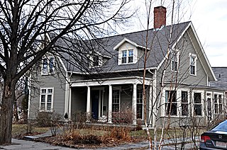
The House at 53 Linden Street in Brookline, Massachusetts, is a well-preserved local example of transitional Greek Revival-Italianate styling. The 2+1⁄2-story wood-frame house was built c. 1843–44 by John Faxon. It has a pedimented gable front with pilasters, but is L-shaped and has round-arch windows in its gables, both Italianate features. It is one of four surviving Greek Revival houses in the neighborhood, which was developed beginning in 1840.

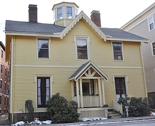
The House at 9 Linden Street in Brookline, Massachusetts, USA, is a locally rare example of transitional Greek Revival and Italianate styling, and one of the few surviving houses from the original development of the Linden Street area in the 1840s. The 2+1⁄2-story wood-frame house was built in 1843 for Isaac Rich, a partner in a successful merchant firm and a co-founder of Boston University. The house's mansard roof is a later addition, probably dating to the 1860s.

Linden Park is a small municipal park at Linden Place and Linden Street in Brookline, Massachusetts, USA. The triangular park was created in 1843 as one of several parks in the Lindens subdivision of the area by Thomas Aspinwall Davis, which was the first residential subdivision created in Brookline. In addition to generous setbacks, the deeds for the lots of this subdivision contained covenants excluding the sale to "Negroes or natives of Ireland".

Reservoir Park is a historic park on Boylston Street in Brookline, Massachusetts. Its principal feature is Brookline Reservoir, formerly an element of the public water supply for neighboring Boston.

Saint Mary of the Assumption Church, Rectory, School and Convent is a historic church complex at 67 Harvard Street, and 3 and 5 Linden Place, in Brookline, Massachusetts in the Archdiocese of Boston. It was the first Roman Catholic Church in Brookline, and the first in the nation to bear the name. Most of its buildings were built between 1880 and 1906, and are reflective of the growth of the area's Irish immigrant community during that time. The complex was listed on the National Register of Historic Places in 1985.

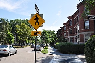
The Strathmore Road Historic District is a residential historic district on Strathmore Road and Clinton Path in Brookline, Massachusetts. It consists of six brick apartment blocks, four of which lie on Strathmore Road, and two of which lie on Clinton Path. The two streets form a loop just south of the westernmost portion of Beacon Street, and abutting the MBTA Green Line yard at Cleveland Circle. The district is reflective of the area's growth as a commuter suburb following the development of the rail line along Beacon Street, and was listed on the National Register of Historic Places in 1985.


