The Possession Islands are a group of small islands and rocks extending over an area of about 7 nautical miles, lying in the western part of the Ross Sea, lying 5 nautical miles south-east of Cape McCormick, in Victoria Land, Antarctica. The Possession Islands were named by Captain James Clark Ross, Royal Navy, in commemoration of the planting of the British flag here on January 12, 1841.
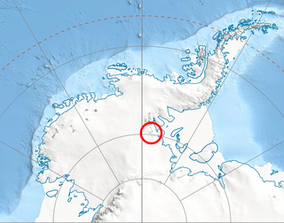
Ahrnsbrak Glacier is a glacier in the Enterprise Hills of the Heritage Range in Antarctica, flowing north between Sutton Peak and Shoemaker Peak to the confluent ice at the lower end of Union Glacier. It was mapped by the United States Geological Survey from surveys and U.S. Navy air photos, 1961–66, and was named by the Advisory Committee on Antarctic Names for William F. Ahrnsbrak of the United States Antarctic Research Program, a glaciologist at Palmer Station in 1965.
Lancing Glacier is a glacier 3 nautical miles (6 km) long, flowing south from Mount Corneliussen and Smillie Peak to Newark Bay on the south side of South Georgia. It was surveyed by the South Georgia Survey in the period 1951–57, and named by the UK Antarctic Place-Names Committee for the Lancing, built in 1898, and converted to a whale factory ship in 1923. It was the first factory ship to be fitted with a slipway.
All-Blacks Nunataks is a group of conspicuous nunataks lying midway between Wallabies Nunataks and Wilhoite Nunataks at the southeast margin of the Byrd Névé in Antarctica. Named by the New Zealand Geological Survey Antarctic Expedition (1960–61) after the well-known New Zealand national rugby union team.
Beaudoin Peak is a snow-free peak, 980 metres (3,200 ft) high, surmounting the southeast part of the Meyer Hills in the Heritage Range. It was mapped by the United States Geological Survey from surveys and from U.S. Navy air photos, 1961–66, and named by the Advisory Committee on Antarctic Names for Douglas W. Beaudoin, United States Antarctic Research Program meteorologist at Ellsworth Station, 1961.
Gowan Glacier is a glacier about 15 nautical miles long in the Heritage Range of the Ellsworth Mountains of Antarctica, flowing north from the vicinity of Cunningham Peak in the Founders Escarpment to enter Minnesota Glacier just east of Welcome Nunatak. It was mapped by the United States Geological Survey from surveys and U.S. Navy air photos, 1961–66, and was named by the Advisory Committee on Antarctic Names for Lieutenant Jimmy L. Gowan, U.S. Navy Medical Corps, officer in charge and doctor at Plateau Station in 1966.
Plummer Glacier is a short glacier descending east through the Enterprise Hills to the north of Lippert Peak and the Douglas Peaks, in the Heritage Range in Antarctica. Mapped by United States Geological Survey (USGS) from surveys and U.S. Navy air photos, 1961–66. Named by Advisory Committee on Antarctic Names (US-ACAN) for Charles C. Plummer, United States Antarctic Research Program (USARP) glaciologist at Palmer Station in 1965.
Fendorf Glacier is a broad glacier draining from the eastern slopes of the Gifford Peaks and flowing north to merge with Dobbratz Glacier, in the Heritage Range of the Ellsworth Mountains, Antarctica. It was mapped by the United States Geological Survey from ground surveys and U.S. Navy air photos, 1961–66, and was named by the Advisory Committee on Antarctic Names for Lieutenant Commander James E. Fendorf, U.S. Navy, a pilot with Squadron VX-6 during Operation Deep Freeze 1966.
Goldsmith Glacier is a glacier flowing west-northwest through the Theron Mountains of Antarctica, 6 nautical miles (11 km) south of Tailend Nunatak. It was first mapped in 1956–57 by the Commonwealth Trans-Antarctic Expedition (CTAE) and named for Rainer Goldsmith, medical officer with the advance party of the CTAE in 1955–56.
Miethe Glacier is a glacier 3 nautical miles (6 km) long, flowing northwest into Gerlache Strait to the south of Mount Banck, on the west coast of Graham Land, Antarctica. The glacier appears on an Argentine government chart of 1952. It was named by the UK Antarctic Place-Names Committee in 1960 for Adolf Miethe, a German chemist who introduced the first panchromatic emulsion for photographic plates in 1903.

Lucchitta Glacier is a glacier about 20 nautical miles (37 km) long flowing south from the Hudson Mountains of Antarctica into Pine Island Bay. It was named by the Advisory Committee on Antarctic Names after geologist Baerbel K. Lucchitta of the United States Geological Survey, Flagstaff, Arizona, a specialist in the use of satellite imagery for geological and glaciological studies from the early 1980s to the early 2000s (decade), and one of the pioneers in the use of imagery for glacier velocity measurements in Antarctica.
Mimas Peak is a sharp conspicuous peak, rising to about 1,000 metres (3,300 ft) west of the head of Saturn Glacier and 9 nautical miles (17 km) west of the Dione Nunataks in the southeast part of Alexander Island, Antarctica. It was first seen and photographed from the air by Lincoln Ellsworth on November 23, 1935, and mapped from these photos by W.L.G. Joerg. The peak was sighted from a distance in 1949 by the Falkland Islands Dependencies Survey (FIDS) and roughly positioned. It was named by the UK Antarctic Place-Names Committee for its association with nearby Saturn Glacier, Mimas being one of the satellites of the planet Saturn. The peak and surrounding area were first mapped in detail from air photos taken by the Ronne Antarctic Research Expedition 1947–48, by D. Searle of the FIDS in 1960. Note that some maps incorrectly attach the name to a subsidiary and smaller peak off the east flank of the mountain. The name is actually attached to the highest peak in the Herschel Heights range.
McMorrin Glacier is a glacier flowing west from Mount Metcalfe to Marguerite Bay in Graham Land, Antarctica. it was named by the UK Antarctic Place-Names Committee for Ian McMorrin, a British Antarctic Survey general assistant at Stonington Island, 1961–63, who helped survey this area in 1962.
Hudak Peak is a peak rising to 1,440 metres (4,720 ft) immediately south of Plummer Glacier in the Douglas Peaks of the Heritage Range, in the Ellsworth Mountains of Antarctica. It was named by the Advisory Committee on Antarctic Names in 2004 after Curtis M. Hudak, a geologist on the United States Antarctic Research Program 1979–80 Ellsworth Mountains expedition.
Henderson Glacier is a glacier approximately 7 nautical miles long in the Enterprise Hills of the Heritage Range, Antarctica. It flows northeast from Schoeck Peak and Hoinkes Peak to enter Union Glacier just east of Mount Rossman. Henderson Glacier was mapped by the United States Geological Survey from surveys and U.S. Navy air photos 1961–66, and was named by the Advisory Committee on Antarctic Names for Felix E. Henderson, a United States Antarctic Research Program meteorologist at Eights Station in 1965.
Knallen Peak is a small rock peak 2 nautical miles (4 km) west of Pyramiden Nunatak, at the east side of the head of Schytt Glacier in Queen Maud Land, Antarctica. It was mapped by Norwegian cartographers from surveys and air photos by the Norwegian–British–Swedish Antarctic Expedition (1949–52) and named Knallen.
Kjellberg Peak is a small rock peak at the head of Frostlendet Valley, about 4 nautical miles (7 km) west of Ryvingen Peak, in the southern part of the Borg Massif of Queen Maud Land, Antarctica. It was mapped by Norwegian cartographers from surveys and air photos by the Norwegian–British–Swedish Antarctic Expedition (1949–52) and named for Sigvard Kjellberg, a photographer with the Norwegian air unit of the expedition.
Kirchner Peak is a somewhat isolated peak, 1,170 metres (3,840 ft) high, located 2 nautical miles (4 km) north-northeast of Gaylord Ridge in the Nebraska Peaks, Antarctica. It was named by the Advisory Committee on Antarctic Names after J.F. Kirchner, a member of the United States Antarctic Research Program geophysical field party during the Ross Ice Shelf Project, 1974–75 and 1976–77 seasons.
Holt Peak is a bare rock peak, 850 metres (2,800 ft) high, surmounting the northeast end of the Meyer Hills in the Heritage Range of Antarctica. It was mapped by the United States Geological Survey from surveys and U.S. Navy air photos from 1961 to 1966, and was named by the Advisory Committee on Antarctic Names for William C. Holt, a United States Antarctic Research Program auroral scientist at Ellsworth Station in 1961.

Sowers Glacier is a glacier that flows from the prominent cirque on the east side of Craddock Massif and continues between Willis Ridge on the north, and Sanchez Peak and Stolnik Peak on the south, to join Thomas Glacier north of Mount Osborne, in the Sentinel Range, Ellsworth Mountains in Antarctica.