![]() | Parts of this article (those related to Tornado count) need to be updated. The reason given is: List page number does not match main page number.(December 2023) |
This page documents all tornadoes confirmed by Environment Canada and the University of Western Ontario's Northern Tornadoes Project (NTP) in Canada throughout 2023. Based on statistical modelling by Sills et al. (2012), an average of 230 tornadoes likely occur across the country each year; however, only 61 of these are actually documented annually based on 1980–2009 averages. [1] This makes Canada the second-most active country in the world for tornadoes. [2] The majority of confirmed events occur in the more densely populated areas of southern Canada, where people are around to report them. [3] In Alberta specifically, meteorologists estimated that 30–50 percent of tornadoes that actually occur go unreported, with NTP executive director David Sills stating, "we just don't get reports from the moose." [4] In an attempt to better document the nation's tornadoes, the NTP was founded in 2017 as a joint venture by the University of Western Ontario and ImpactWX. Their initial scope was to catalogue previously unrecognized tornadoes in densely forested areas across Ontario and Quebec; however, this later expanded to tornadoes nationwide in 2019. [1]
The year started slowly, possibly due to thunderstorm activity being suppressed by smoke from record-breaking wildfires. [2] The first tornado of 2023 occurred on May 11 in Alberta while the strongest was an EF4 tornado on July 1, also in Alberta. The most active day of the year was an outbreak of 10 EF0 tornadoes on June 14 in rural areas of Alberta. [5]
Month | Total | Enhanced Fujita scale rating | Deaths | Injuries | |||||
---|---|---|---|---|---|---|---|---|---|
EF0 | EF1 | EF2 | EF3 | EF4 | EF5 | ||||
January | 0 | 0 | 0 | 0 | 0 | 0 | 0 | 0 | 0 |
February | 0 | 0 | 0 | 0 | 0 | 0 | 0 | 0 | 0 |
March | 0 | 0 | 0 | 0 | 0 | 0 | 0 | 0 | 0 |
April | 0 | 0 | 0 | 0 | 0 | 0 | 0 | 0 | 0 |
May | 3 | 2 | 1 | 0 | 0 | 0 | 0 | 0 | 0 |
June | 25 | 22 | 3 | 0 | 0 | 0 | 0 | 0 | 0 |
July | 18 | 10 | 7 | 0 | 0 | 1 | 0 | 0 | 1 |
August | 1 | 1 | 0 | 0 | 0 | 0 | 0 | 0 | 0 |
Total | 47 | 35 | 11 | 0 | 0 | 1 | 0 | 0 | 1 |
EF# | Location | County / District / Municipality | Province | Start Coord. | Date | Time (UTC) | Path length | Max width |
---|---|---|---|---|---|---|---|---|
EF1 | S of Cayley | Foothills | Alberta | 50°25′N113°51′W / 50.42°N 113.85°W | May 11 | 00:07 | — | — |
A brief landspout tornado was videoed; no damage was observed. [6] This was the first landspout classified as a tornado by the NTP following a change in operations in June 2023. [7] | ||||||||
EF1 | S of Regina | Sherwood No. 159 | Saskatchewan | 50°21′19″N104°33′13″W / 50.3553°N 104.5535°W | May 27 | 01:52 | 0.6 km (0.37 mi) | 200 m (220 yd) |
A brief tornado tore the roof from a large machine shed, causing one of its walls to collapse, and scattered debris up to 2.5 km (1.6 mi) downstream. [8] The tornado was described as being unusual for this time of year. [9] Equally unusual is that this was the only tornado reported in Saskatchewan in 2023. [10] | ||||||||
EF0 | N of Botha | Stettler No. 6 | Alberta | 52°20′55″N112°33′13″W / 52.3486°N 112.5536°W | May 31 | 22:35 | 2.33 km (1.45 mi) | 240 m (260 yd) |
A tornado was videoed and high-resolution satellite imagery revealed a damage swath through crop fields. [6] | ||||||||
EF0 | NW of Carberry | North Cypress – Langford | Manitoba | 49°53′04″N99°22′17″W / 49.8844°N 99.3714°W | June 4 | 23:53 | 0.46 km (0.29 mi) | 70 m (77 yd) |
A brief landspout tornado was videoed; no damage occurred. [6] | ||||||||
EF0 | S of Lomond | Vulcan | Alberta | 50°18′N112°38′W / 50.30°N 112.63°W | June 11 | 00:55 | — | — |
A tornado was videoed; no damage occurred. [6] | ||||||||
EF0 | S of Beachville | South-West Oxford | Ontario | 43°04′05″N80°49′48″W / 43.068°N 80.83°W | June 13 | 23:39 | — | — |
A brief tornado was videoed; no damage occurred. [6] | ||||||||
EF0 | NW of Talbotville | Southwold | Ontario | 42°48′22″N81°15′24″W / 42.8062°N 81.2567°W | June 13 | 00:30 | 2.44 km (1.52 mi) | 40 m (44 yd) |
A brief tornado tossed patio furniture at a restaurant and damaged trees. [6] A 2x4 was lodged into the wall of the building. [2] | ||||||||
EF0 | N of Iron Springs | Lethbridge | Alberta | 49°56′56″N112°41′38″W / 49.949°N 112.694°W | June 14 | 20:20 | — | — |
A brief tornado was videoed; no damage occurred. [6] | ||||||||
EF0 | N of Turin | Lethbridge | Alberta | 50°00′47″N112°32′17″W / 50.013°N 112.538°W | June 14 | 20:42 | — | — |
A brief tornado was videoed; no damage occurred. [6] | ||||||||
EF0 | NW of Turin | Lethbridge | Alberta | 50°00′25″N112°37′44″W / 50.007°N 112.629°W | June 14 | 20:46 | — | — |
A brief tornado was videoed; no damage occurred. [6] | ||||||||
EF0 | NNW of Turin | Lethbridge | Alberta | 50°02′20″N112°36′47″W / 50.039°N 112.613°W | June 14 | 20:58 | — | — |
A brief tornado was videoed; no damage occurred. [6] | ||||||||
EF0 | SW of Enchant | Taber | Alberta | 50°07′08″N112°26′35″W / 50.119°N 112.443°W | June 14 | 21:15 | — | — |
A brief tornado was videoed; no damage occurred. [6] | ||||||||
EF0 | SE of Enchant | Taber | Alberta | 50°07′41″N112°20′46″W / 50.128°N 112.346°W | June 14 | 21:23 | — | — |
A brief tornado was videoed; an irrigation pivot was overturned. [6] | ||||||||
EF0 | S of Brooks | Newell | Alberta | 50°26′13″N111°56′20″W / 50.437°N 111.939°W | June 14 | 22:12 | — | — |
A brief waterspout was videoed over Lake Newell; the NTP classified it as an EF0 tornado. No damage occurred. [6] | ||||||||
EF0 | SE of Brooks | Newell | Alberta | 50°31′12″N111°51′14″W / 50.52°N 111.854°W | June 14 | 22:35 | — | — |
A brief tornado was videoed; no damage occurred. [6] | ||||||||
EF0 | N of Vermilion | Vermilion River | Alberta | 53°24′N110°51′W / 53.40°N 110.85°W | June 14 | 22:40 | — | — |
A brief tornado was videoed; no damage occurred. [6] | ||||||||
EF0 | S of Cabin Lake | Special Area No. 3 | Alberta | 51°01′N111°13′W / 51.01°N 111.22°W | June 14 | 00:07 | — | — |
A brief tornado was videoed; no damage occurred. [6] | ||||||||
EF1 | NNE of Carpenter (ND) to William Lake Provincial Park (MB) | Rolette (ND), Morton (MB) | North Dakota (USA), Manitoba | 48°59′54″N99°57′37″W / 48.9983°N 99.9603°W | June 20 | 02:35 | ≥6.5 km (4.0 mi) | ≥210 m (230 yd) |
Aerial surveys revealed a tornado touched down just south of the Canada–United States border and moved northeast into Canada. Damage was confined to trees. [11] Only the Canadian portion of the track was surveyed. [6] [12] | ||||||||
EF1 | NW of Killarney to SE of Ninette | Killarney-Turtle Mountain, Prairie Lakes | Manitoba | 49°13′59″N99°44′53″W / 49.2331°N 99.748°W | June 20 | 02:55 | 17.5 km (10.9 mi) | 1,200 m (1,300 yd) |
A large tornado was confirmed through aerial surveys; details pending. [6] [12] | ||||||||
EF1 | NE of MacGregor | North Norfolk | Manitoba | 49°59′26″N98°41′55″W / 49.9906°N 98.6987°W | June 20 | 04:30 | 6.8 km (4.2 mi) | 800 m (870 yd) |
This tornado occurred within a broader area of straight-line winds. Grain bins were tossed and trees were downed and/or damaged. [6] [13] | ||||||||
EF0 | RiverWest | Windsor | Ontario | 42°17′25″N83°03′15″W / 42.2903°N 83.0542°W | June 25 | 22:45 | 2.02 km (1.26 mi) | 180 m (200 yd) |
A brief, dusty tornado caused minor tree damage. [6] | ||||||||
EF0 | Forest Glade to Tecumseh | Windsor | Ontario | 42°18′21″N82°54′33″W / 42.3057°N 82.9091°W | June 25 | 23:00 | 4.69 km (2.91 mi) | 120 m (130 yd) |
A tornado moved through eastern areas of Windsor, causing minor roof damage to multiple homes and snapping tree branches. [6] | ||||||||
EF0 | S of Clearview | Clearview | Ontario | 44°23′09″N80°06′13″W / 44.3857°N 80.1035°W | June 26 | 19:20 | 2.82 km (1.75 mi) | 120 m (130 yd) |
A short-lived tornado caused minor damage to homes, fences, trees, and crops. [6] | ||||||||
EF0 | SSW of Tweed | Tweed | Ontario | 44°27′11″N77°19′20″W / 44.4531°N 77.3223°W | June 26 | 20:35 | 6.13 km (3.81 mi) | 450 m (490 yd) |
A weak tornado moved along the western side of Stoco Lake. [6] | ||||||||
EF0 | NE of Tweed | Tweed | Ontario | 44°29′28″N77°16′25″W / 44.4911°N 77.2735°W | June 26 | 20:45 | 3.28 km (2.04 mi) | 240 m (260 yd) |
A weak tornado touched down near where the first Tweed tornado dissipated along the northern end of Stoco Lake. [6] | ||||||||
EF0 | ENE of Neepawa | WestLake – Gladstone | Manitoba | 50°16′N99°12′W / 50.26°N 99.20°W | June 26 | 23:05 | — | — |
A brief tornado was videoed; no damage occurred. [6] | ||||||||
EF0 | SW of Venlaw | Grandview | Manitoba | 51°16′06″N100°32′54″W / 51.2682°N 100.5483°W | June 28 | 17:53 | 1.29 km (0.80 mi) | 10 m (11 yd) |
A brief, narrow tornado caused minor crop damage. [6] | ||||||||
EF0 | SSE of Brookdale | North Cypress – Langford | Manitoba | 50°00′18″N99°32′11″W / 50.0051°N 99.5363°W | June 28 | 19:20 | 0.8 km (0.50 mi) | 10 m (11 yd) |
A brief, narrow tornado caused minor crop damage. [6] | ||||||||
EF4 | SW of Didsbury to ENE of Carstairs | Mountain View | Alberta | 51°36′41″N114°11′56″W / 51.6114°N 114.1989°W | July 1 | 19:45–20:15 | 15.3 km (9.5 mi) | 620 m (680 yd) |
This violent tornado initially touched down over rural areas southwest of Didsbury, oscillating in intensity as it moved east. The tornado produced EF4 damage along Highway 2A between Didsbury and Carstairs. There, a well-built home was completely destroyed; [14] the sole occupant was injured. [15] Near this home, a 22,000 lb (10,000 kg) combine harvester was thrown 160 ft (50 m) before being rolled a further 160 to 330 ft (50 to 100 m). Trees were stubbed and debarked on the property. [16] Power lines were downed and one gas leak occurred at a destroyed home. [15] Significant ground scouring was observed in the area. [17] The tornado turned east-southeast from this location, eventually crossing Highway 2 before dissipating. [14] [16] Altogether, three homes were destroyed, four were rendered uninhabitable, and five were damaged. [16] Twenty-five cows, twenty chickens, and one horse were also killed. [15] | ||||||||
EF0 | Southern Hamilton | Hamilton (City of) | Ontario | 43°11′51″N79°50′32″W / 43.1975°N 79.8423°W | July 4 | 20:45 | 0.64 km (0.40 mi) | 20 m (22 yd) |
A brief tornado touched down in the Templemead neighbourhood of southern Hamilton. One business had minor roof damage. [6] This was the first tornado to strike the city in 18 years. [18] | ||||||||
EF1 | Hine Lake | Thunder Bay, Unorganized | Ontario | 49°18′10″N89°56′24″W / 49.3028°N 89.9400°W | July 9 | 23:45 | 12 km (7.5 mi) | 400 m (440 yd) |
A tornado was analyzed in a forested area through satellite imagery. The full path is uncertain pending cloud-free satellite images. [6] | ||||||||
EF1 | Barrhaven (1st tornado) | Ottawa (City of) | Ontario | 45°15′55″N75°45′35″W / 45.2654°N 75.7598°W | July 13 | 12:49 | 1.13 km (0.70 mi) | 150 m (160 yd) |
Dozens of homes sustained minor to moderate roof damage, including a couple that had portions peeled away. Some trees were snapped or uprooted. [6] | ||||||||
EF1 | Barrhaven (2nd tornado) | Ottawa (City of) | Ontario | 45°14′42″N75°45′07″W / 45.2451°N 75.7519°W | July 13 | 16:45 | 4.92 km (3.06 mi) | 200 m (220 yd) |
Dozens of homes sustained minor to moderate roof damage, including a couple that had portions peeled away. Some trees were snapped or uprooted. [6] | ||||||||
EF0 | Embrun | Russell | Ontario | 45°16′17″N75°17′17″W / 45.2715°N 75.2880°W | July 13 | 17:17 | 1.14 km (0.71 mi) | 80 m (87 yd) |
A brief, narrow tornado caused minor roof damage to homes and damaged trees. [19] | ||||||||
EF0 | Fournier to Fenaghvale | The Nation | Ontario | 45°26′16″N74°56′05″W / 45.4379°N 74.9346°W | July 13 | 17:55 | 9.62 km (5.98 mi) | 510 m (560 yd) |
Damage was limited to trees and crops. [19] | ||||||||
EF0 | Mirabel | Mirabel | Quebec | 45°39′N74°01′W / 45.65°N 74.01°W | July 13 | 19:23 | — | — |
An observer at Montréal–Mirabel International Airport reported a tornado. [6] | ||||||||
EF0 | Saint-Thomas | Saint-Thomas | Quebec | 45°59′43″N73°21′47″W / 45.9952°N 73.3631°W | July 13 | 20:25 | 6.61 km (4.11 mi) | 200 m (220 yd) |
Two barns and a home sustained minor roof damage and trees were snapped. [6] | ||||||||
EF0 | W of Okotoks | Foothills County | Alberta | 50°39′25″N114°05′46″W / 50.657°N 114.096°W | July 17 | 20:39 | — | — |
A landspout tornado was observed. [6] | ||||||||
EF0 | S of Whitla | Forty Mile No. 8 | Alberta | 49°42′N111°01′W / 49.70°N 111.01°W | July 17 | 01:30 | — | — |
A non-damaging tornado was documented. [20] | ||||||||
EF1 | Brompton | Sherbrooke | Quebec | 45°27′58″N71°59′20″W / 45.466°N 71.9888°W | July 18 | 20:30 | 3.93 km (2.44 mi) | 370 m (400 yd) |
Barns, trees, and crops were damaged. [6] At least two barns partially collapsed, one of which was properly anchor bolted to its foundation. [21] | ||||||||
EF0 | Near Bathurst | None (in water) | New Brunswick | 47°41′N65°38′W / 47.69°N 65.63°W | July 20 | 20:09 | 10.5 km (6.5 mi) | 175 m (191 yd) |
A tornado was observed over Chaleur Bay. [22] | ||||||||
EF0 | E of Petrolia | Enniskillen | Ontario | 42°52′47″N82°01′26″W / 42.8798°N 82.0240°W | July 20 | 20:25 | 2.91 km (1.81 mi) | 300 m (330 yd) |
Trees, crops, and one power pole were damaged. [23] | ||||||||
EF1 | South Buxton to SE of Sandison | Chatham-Kent | Ontario | 42°17′29″N82°11′08″W / 42.2915°N 82.1855°W | July 20 | 20:50 | 10.5 km (6.5 mi) | 175 m (191 yd) |
Multiple homes sustained varying degrees of roof damage. One had up to 20 percent of its roof torn off. Crops and trees were also damaged. [23] | ||||||||
EF0 | Lake Nipissing | West Nipissing | Ontario | 46°13′30″N79°51′25″W / 46.225°N 79.857°W | July 20 | 22:50 | 10.5 km (6.5 mi) | 175 m (191 yd) |
A tornado was observed over Lake Nipissing. [22] | ||||||||
EF1 | Blenheim | Chatham-Kent | Ontario | 42°18′26″N82°03′54″W / 42.3073°N 82.0649°W | July 26 | 20:35 | 9.77 km (6.07 mi) | 300 m (330 yd) |
Trees were snapped or uprooted, at least one home had moderate roof damage, and a garage was destroyed. [24] | ||||||||
EF1 | W of Beaver Creek | Unorganized Division No. 19 | Manitoba | 51°21′35″N97°07′29″W / 51.3597°N 97.1247°W | July 26 | 23:23 | 2 km (1.2 mi) | 170 m (190 yd) |
A tornado caused tree and crop damage. Full survey details pending analysis of satellite imagery as of July 29. [25] | ||||||||
EF0 | Findlay Creek (1st Tornado) | Ottawa | Ontario | 45°17′17″N75°37′34″W / 45.288°N 75.6262°W | August 3 | 17:36 | 6.1 km (3.8 mi) | 130 m (140 yd) |
A few homes and sheds sustained minor damage, a trailer was flipped, and trees were damaged. [6] | ||||||||
EF0 | Findlay Creek (2nd Tornado, then later updated) | Ottawa | Ontario | 45°17′17″N75°37′34″W / 45.288°N 75.6262°W | August 3 | 17:36 | 6.1 km (3.8 mi) | 130 m (140 yd) |
A few homes and sheds sustained minor damage, a trailer was flipped, and trees were damaged. [6] | ||||||||
Tornado Alley, also known as Tornado Valley, is a loosely defined location of the central United States and Canada where tornadoes are most frequent. The term was first used in 1952 as the title of a research project to study severe weather in areas of Texas, Louisiana, Oklahoma, Kansas, South Dakota, Iowa and Nebraska. Tornado climatologists distinguish peaks in activity in certain areas and storm chasers have long recognized the Great Plains tornado belt.
This page documents the tornadoes and tornado outbreaks that occurred in 2007, primarily in the United States. Most tornadoes form in the U.S., although some events may take place internationally, particularly in parts of neighboring southern Canada during the summer season. Some tornadoes also take place in Europe, e. g. in the United Kingdom or in Germany.
This page documents notable tornadoes and tornado outbreaks worldwide in 2009. Strong and destructive tornadoes form most frequently in the United States, Argentina, Brazil, Bangladesh, and Eastern India, but can occur almost anywhere under the right conditions. Tornadoes also develop occasionally in southern Canada during the Northern Hemisphere's summer and somewhat regularly at other times of the year across Europe, Asia, Argentina, Australia and New Zealand. Tornadic events are often accompanied by other forms of severe weather, including strong thunderstorms, strong winds, and hail. In the U.S., there were 1,304 reports of tornadoes received by the Storm Prediction Center (SPC), and 1,159 tornadoes were confirmed to have taken place. Worldwide, 73 fatalities were caused by tornadoes; 22 in the United States, 20 in India, 11 in Argentina, eight in the Philippines, four each in Canada and Brazil, two in Greece and one each in Serbia and Russia.
This page documents the tornadoes and tornado outbreaks of 2010. The majority of tornadoes form in the U.S., but they can occur almost anywhere under the right conditions. A lesser number occur outside the U.S., most notably in parts of neighboring southern Canada during the Northern Hemisphere's summer season, but are also known in South America, Europe, Asia, and Australia.
The June 2010 Northern Plains tornado outbreak was one of the most prolific summer tornado outbreaks in the Northern Great Plains of the United States on record. The outbreak began on June 16, with several tornadoes in South Dakota and Montana. The most intense storms took place the following day across much of eastern North Dakota and much of Minnesota. The system produced 93 tornadoes reported across four states while killing three people in Minnesota. Four of the tornadoes were rated as EF4 on the Enhanced Fujita scale, the most violent tornadoes in a 24-hour period since there were five within 15 hours in the 2008 Super Tuesday tornado outbreak. This was the region's first major tornado outbreak of the year and one of the largest on record in the region, comparable to a similar outbreak in June 1992. The 48 tornadoes that touched down in Minnesota on June 17 marked the most active single day in the state's history. June 17 was the second largest tornado day on record in the meteorological summer, behind the most prolific day of the 2003 South Dakota tornado outbreak on June 24, 2003.
One of several tornado outbreaks in the United States to take place during the record month of April 2011, 49 tornadoes were produced across the Midwest and Southeast from April 9–11. Widespread damage took place; however, no fatalities resulted from the event due to timely warnings. In Wisconsin, 16 tornadoes touched down, ranking this outbreak as the state's largest April event on record as well as one of the largest single-day events during the course of any year. The strongest tornado of the outbreak was an EF4 tornado that touched down west of Pocahontas, Iowa on April 9, a short-lived satellite to a long-track EF3 tornado. Between 0256 and 0258 UTC that day, five tornadoes were on the ground simultaneously in Pocahontas County, Iowa, all of which were from one supercell thunderstorm. Other tornadoes impacted parts of eastern Kentucky and Tennessee on April 9, hours before the event in Iowa.
This page documents the tornadoes and tornado outbreaks of 2013. Strong and destructive tornadoes form most frequently in the United States, Bangladesh, Brazil and Eastern India, but they can occur almost anywhere under the right conditions. Tornadoes also appear regularly in neighboring southern Canada during the Northern Hemisphere's summer season, and somewhat regularly in Europe, Asia, and Australia.
This page documents the tornadoes and tornado outbreaks of 2014. Strong and destructive tornadoes form most frequently in the United States, Bangladesh, Brazil, and Eastern India, but they can occur almost anywhere under the right conditions. Tornadoes also appear regularly in neighboring southern Canada during the Northern Hemisphere's summer season, and somewhat regularly in Europe, Asia, and Australia.
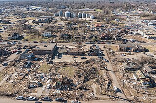
The tornado outbreak of June 16–18, 2014, was a tornado outbreak concentrated in the Great Plains and the Midwestern United States. Two tornadoes also occurred in Ontario. The severe weather event most significantly affected the state of Nebraska, where twin EF4 tornadoes killed two and critically injured twenty others in and around the town of Pilger on the evening of June 16. The two Pilger tornadoes were part of a violent tornado family that produced four EF4 tornadoes and was broadcast live on television. The outbreak went on to produce multiple other strong tornadoes across the northern Great Plains states throughout the next two days.
A destructive, two-day tornado outbreak affected the Great Lakes region of the United States and the National Capital Region of Canada in late-September. A total of 37 tornadoes were confirmed, including a violent long-tracked high-end EF3 tornado that moved along a 80 km (50 mi) path from near Dunrobin, Ontario to Gatineau, Quebec, and an EF2 tornado in the Nepean sector of Ottawa. The tornadoes in Ottawa-Gatineau were declared one of the ten most significant weather events of 2018 in Canada by the Meteorological Service of Canada.
This page documents notable tornadoes and tornado outbreaks worldwide in 2020. Strong and destructive tornadoes form most frequently in the United States, Argentina, Brazil, Bangladesh, and eastern India, but can occur almost anywhere under the right conditions. Tornadoes also develop occasionally in southern Canada during the Northern Hemisphere's summer and somewhat regularly at other times of the year across Europe, Asia, Argentina, Australia and New Zealand. Tornadic events are often accompanied by other forms of severe weather, including strong thunderstorms, strong winds, and hail. There were 1,243 preliminary filtered reported tornadoes in 2020 in the United States in 2020, and 1,086 confirmed tornadoes in the United States in 2020. Worldwide, at least 93 tornado-related deaths were confirmed with 78 in the United States, eight in Vietnam, two each in Canada, Indonesia, and Mexico, and one in South Africa.
This page documents notable tornadoes and tornado outbreaks worldwide in 2021. Strong and destructive tornadoes form most frequently in the United States, Argentina, Brazil, Bangladesh, and Eastern India, but can occur almost anywhere under the right conditions. Tornadoes also develop occasionally in southern Canada during the Northern Hemisphere's summer and somewhat regularly at other times of the year across Europe, Asia, Argentina, Australia and New Zealand. Tornadic events are often accompanied by other forms of severe weather, including strong thunderstorms, strong winds, and hail. Worldwide, 150 tornado-related deaths were confirmed with 103 in the United States, 28 in China, six in the Czech Republic, four in Russia, three in Italy, two in India, and one each in Canada, New Zealand, Indonesia, and Turkey.
This page documents notable tornadoes and tornado outbreaks worldwide in 2022. Strong and destructive tornadoes form most frequently in the United States, Argentina, Brazil, Bangladesh, and Eastern India, but can occur almost anywhere under the right conditions. Tornadoes also develop occasionally in southern Canada during the Northern Hemisphere's summer and somewhat regularly at other times of the year across Europe, Asia, Argentina, Australia and New Zealand. Tornadic events are often accompanied by other forms of severe weather, including strong thunderstorms, strong winds, and hail. Worldwide, 32 tornado-related deaths were confirmed: 23 in the United States, three in China, two each in Poland and Russia, and one each in the Netherlands and Ukraine.
A significant early spring tornado outbreak occurred during the afternoon and evening hours of March 5, 2022 in the Midwest, primarily in the state of Iowa, before transitioning to a damaging wind event across northern parts of Illinois and Indiana. Multiple tornadoes were reported, several of which were produced by a dominant supercell thunderstorm in central Iowa. One long-track, low-end EF4 tornado caused major damage near the towns of Winterset and Norwalk, resulting in six fatalities. Multiple other supercells spawned along an area of moderate destabilization in northern Missouri, prompting further tornado warnings in southern Iowa, as they entered a highly favorable environment for maturing. Large hail and damaging wind gusts accompanied the storms, which continued their passage across the Midwestern states into overnight. More tornadic weather was confirmed in Arkansas and Missouri the next day and into the early morning of March 7. In addition to that, straight line winds killed one person near Hazel, Kentucky when a semi trailer was blown over on US 641. Another non-tornadic fatality occurred in western New York as the storm approached.
This is a list of notable tornadoes and tornado outbreaks worldwide in 2023. Strong, destructive tornadoes form most frequently in the United States, Argentina, Brazil, Bangladesh and East India, but can occur almost anywhere. Tornadoes develop occasionally in southern Canada during the Northern Hemisphere's summer, and at other times of the year across Europe, Asia, Argentina, Australia and New Zealand. They are often accompanied by other forms of severe weather, including thunderstorms, strong winds, and large hail. Worldwide, 116 tornado-related deaths were confirmed – 83 in the United States, 12 in China, nine in Indonesia, eight in Myanmar, three in Turkey, and one in Saudi Arabia.