
Pennsylvania state historical markers in Adams County by the Pennsylvania Historical and Museum Commission (PHMC) are 44 signs, [1] including 16 regarding the Gettysburg Campaign.
Pennsylvania state historical markers in Adams County by the Pennsylvania Historical and Museum Commission (PHMC) are 44 signs, [1] including 16 regarding the Gettysburg Campaign.
| Marker title [1] | Image | Date dedicated | Location | Marker type | Topics |
|---|---|---|---|---|---|
| Adams County |  | November 6, 1982 | Old Courthouse, Baltimore & W. Middle Sts. (Bus. 15 & PA 116), Gettysburg 39°49′47″N77°13′53″W / 39.82963°N 77.23132°W | City | Abraham Lincoln, Agriculture, Civil War, Government & Politics, Government & Politics 19th Century |
| Christ Reformed Church |  | February 21, 1950 | Hanover & Christ Church Rds. (PA 194 & SR 2023), 1.1 miles NE of Littlestown 39°45′13″N77°03′27″W / 39.75374°N 77.05745°W | Roadside | Buildings, Early Settlement, Ethnic & Immigration, Religion |
| Conewago Chapel |  | December 12, 1947 | U.S. 30 W of New Oxford 39°51′41″N77°04′07″W / 39.86151°N 77.06869°W | Roadside | Buildings, Religion |
| Daniel Alexander Payne |  | March 10, 1991 | 239 N. Washington St. at Gettysburg College 39°50′04″N77°14′00″W / 39.83448°N 77.23333°W | City | African American, Education, Religion |
| Dobbin House |  | December 12, 1947 | Business U.S. 15 (Steinwehr Ave.) near Pa. 134, Gettysburg 39°49′19″N77°13′56″W / 39.822°N 77.23228°W | Roadside | Buildings, Education |
| Dwight D. Eisenhower | 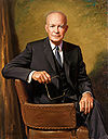 | December 12, 1994 | 157 N. Washington St., Gettysburg 39°50′00″N77°14′01″W / 39.83326°N 77.23356°W | City | Government & Politics, Government & Politics 20th Century, Houses & Homesteads, Military, Military Post-Civil War |
| Eddie Plank | 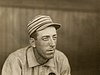 | August 31, 2000 | intersection of Carlisle St. & West Lincoln Ave., Gettysburg 39°50′11″N77°13′53″W / 39.83635°N 77.23134°W | Roadside | Baseball, Sports |
| Field Hospital | | September 1, 1951 | Pa. 116 (Main St.) at St. John Lutheran Church, Fairfield 39°47′15″N77°22′08″W / 39.78739°N 77.36883°W | City | Civil War, Medicine & Science, Military |
| Gettys Crossroads and Tavern | | September 1, 1954 | 44 York St., Gettysburg 39°49′51″N77°13′46″W / 39.83091°N 77.22953°W | City | American Revolution, Business, Roads, Inns & Taverns, Transportation |
| Gettysburg Address | 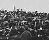 | December 12, 1947 | PA 134 (Taneytown Rd.) at entrance to National Cemetery 39°49′04″N77°13′57″W / 39.8177°N 77.23245°W | Roadside | Abraham Lincoln, Civil War, Government & Politics, Government & Politics 19th Century, Military |
| Gettysburg Address | | December 12, 1947 | Baltimore St. (old US 140) & PA 134 at entrance to National Cemetery 39°49′17″N77°13′46″W / 39.82149°N 77.22957°W | Roadside | Abraham Lincoln, Civil War, Government & Politics, Government & Politics 19th Century |
| Gettysburg Campaign |  | November 13, 1998 | Rt. 30 & Calvary Field Rd., east of Gettysburg 39°50′54″N77°10′57″W / 39.84834°N 77.18249°W | Roadside | Civil War, Military |
| Gettysburg Campaign | 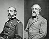 | December 12, 1947 | Fairfield Rd. (PA 116), near Bream's Mill Rd., W of Gettysburg | Roadside | Civil War, Military |
| Gettysburg Campaign | | December 12, 1947 | PA 394 just west of PA 94, Hampton 39°55′45″N77°03′31″W / 39.92926°N 77.05856°W | Roadside | Civil War, Military |
| Gettysburg Campaign | | December 12, 1947 | Old Rte. 30 just west of SR 3011, north of Cashtown 39°53′05″N77°21′38″W / 39.88469°N 77.36048°W | Roadside | Civil War, Military |
| Gettysburg Campaign | | December 12, 1947 | Pa. 134, .7 mile north of state line 39°43′46″N77°12′38″W / 39.72954°N 77.21054°W | Roadside | Civil War, Military |
| Gettysburg Campaign | | December 12, 1947 | SR 3001 (old US 15) just south of Rt. 234, Heidlersburg 39°56′50″N77°08′50″W / 39.94713°N 77.14734°W | Roadside | Civil War, Military |
| Gettysburg Campaign | | December 12, 1947 | Baltimore Pike (US 97), 2 miles SE of Gettysburg 39°48′16″N77°12′35″W / 39.80444°N 77.20972°W | Roadside | Civil War, Military |
| Gettysburg Campaign | | December 12, 1947 | PA 134 at SR 1002 (Taneytown & Barlow-Greenmount Rds.) at Barlow Fire Co. (new location in 2008) 39°45′44″N77°13′56″W / 39.7622°N 77.23235°W | Roadside | Civil War, Military |
| Gettysburg Campaign | | December 18, 1947 | Old US 15 near Marsh Creek, S of Greenmount 39°44′54″N77°16′59″W / 39.74833°N 77.28302°W | Roadside | Civil War, Military |
| Gettysburg Campaign | | December 12, 1947 | SR 3001 (old Rt. 15), just north of Heidlersburg 39°57′15″N77°08′38″W / 39.95424°N 77.14378°W | Roadside | Civil War, Military |
| Gettysburg Campaign | | December 12, 1947 | Herrs Ridge & Biglerville (PA 34) Rds., 3 miles N of Gettysburg 39°50′54″N77°14′38″W / 39.84846°N 77.24387°W | Roadside | Civil War, Military |
| Gettysburg Campaign | | n/a | US 30 just east of PA 94 junction, east of New Oxford 39°52′10″N77°01′52″W / 39.86958°N 77.03123°W | Roadside | Civil War, Military |
| Gettysburg Campaign | | December 12, 1947 | US 30 at W approach to Gettysburg 39°50′16″N77°15′05″W / 39.83769°N 77.2515°W | Roadside | Civil War, Military |
| Gettysburg Campaign | | n/a | U.S. 30 just W of PA 94 junction, E of New Oxford 39°52′23″N77°01′21″W / 39.87296°N 77.02246°W | Roadside | Civil War, Military |
| John Hanson "Hance" Steelman (1655-1749) - PLAQUE | | July 24, 1977 | SW corner intersection of Steelman Marker Rd., Crum Rd. (T-111), & Topper Rd. (T-312), just E of Zora 39°44′06″N77°21′37″W / 39.73498°N 77.36029°W | Plaque | Early Settlement, Ethnic & Immigration, Native American |
| John Hanson Steelman | | December 12, 1977 | Near Pa. 16 & Pa. 116 junction, betw. Zora & state line (Missing) | Roadside | Early Settlement, Ethnic & Immigration, Native American, Professions & Vocations, William Penn |
| John Studebaker |  | December 6, 1948 | Oxford Rd. (SR 1015), just off PA 234, 1/2 mile E of Heidlersburg 39°34′09″N77°04′44″W / 39.56906°N 77.07901°W | Roadside | Business & Industry, Entrepreneurs, Transportation |
| Lincoln Cemetery | | November 15, 2003 | Intersection of Lincoln & Long Lanes, Gettysburg 39°49′34″N77°14′09″W / 39.82616°N 77.23575°W | Roadside | African American, Civil War, Military, Military Post-Civil War |
| Lower Marsh Creek Church | | July 15, 1948 | PA 116 & SR 3013 (Knoxlyn Rd.), 4 miles W of Gettysburg 39°48′38″N77°19′16″W / 39.81061°N 77.3211°W | Roadside | Buildings, Religion |
| Manor of Maske | 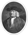 | August 11, 1954 | U.S. 30 at E end of Gettysburg 39°50′09″N77°13′02″W / 39.83576°N 77.21736°W | Roadside | Buildings, Mansions & Manors, William Penn |
| Manor of Maske | | August 11, 1954 | U.S. 30 near SR 1077, W of Seven Stars 39°51′54″N77°18′48″W / 39.86488°N 77.31337°W | Roadside | Buildings, Mansions & Manors, William Penn |
| Mary Jemison | 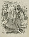 | December 12, 1947 | U.S. 30 at PA 234 junction, 4 miles W of Cashtown 39°53′51″N77°26′10″W / 39.89749°N 77.43612°W | Roadside | French & Indian War, Native American, Women |
| Old Courthouse | | September 1, 1954 | SW section of Square, York (Rt. 30) & Baltimore Sts., Gettysburg 39°49′51″N77°13′51″W / 39.83093°N 77.23087°W | City | Government & Politics, Government & Politics 19th Century |
| Pennsylvania |  | December 6, 1948 | U.S. 15, 200 yards from state line 39°43′11″N77°18′23″W / 39.71984°N 77.3065°W | Roadside | Government & Politics, Government & Politics 17th Century, William Penn |
| Pennsylvania | | December 6, 1946 | US 97 at Mathias Rd., .4 mile from state line (MISSING) | Roadside | Government & Politics, Government & Politics 17th Century, William Penn |
| Rock Chapel | | December 12, 1947 | SR 3001 / Old US 15 (Old Harrisburg Rd.) & SR 1016 (Oxford Rd.), N of Heidlersburg 39°57′39″N77°08′25″W / 39.96082°N 77.14032°W | Roadside | Buildings, Religion |
| Rural Electrification | | August 21, 1990 | Pa. 34 near Palace Dr., 1.7 miles N of Gettysburg 39°51′47″N77°14′18″W / 39.86307°N 77.23836°W | Roadside | Business & Industry, Electricity |
| Russell Tavern | | December 12, 1947 | Pa. 34 at Goldenville Rd., 4 miles N of Gettysburg (MISSING) 39°53′32″N77°14′46″W / 39.89217°N 77.24621°W | Roadside | Buildings, Business & Industry, George Washington, Military, Inns & Taverns, Whiskey Rebellion |
| Sachs Covered Bridge |  | July 20, 1997 | Pumping Station Rd. (SR 3005) & Waterworks Rd., SW of Eisenhower Nat'l. Hist site, Gettysburg 39°47′55″N77°16′45″W / 39.79856°N 77.27915°W | Roadside | Bridges, Civil War, Transportation |
| Studebaker Home |  | August 15, 1970 | 200 W. King St. (PA 234) W of Abbottstown St. (PA 194), East Berlin 39°56′21″N76°58′50″W / 39.93912°N 76.98063°W | City | Buildings, Houses & Homesteads, Professions & Vocations, Religion |
| Tapeworm Railroad | | May 2, 1967 | Fairfield Rd. (PA 116) & Iron Springs Rd. (SR 3014), SW of Fairfield 39°46′53″N77°22′42″W / 39.78133°N 77.37821°W | Roadside | Railroads, Transportation |
| Thaddeus Stevens | 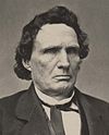 | September 1, 1954 | 51 Chambersburg St., Gettysburg 39°49′51″N77°13′58″W / 39.83097°N 77.23276°W | City | African American, Business & Industry, Education, Government & Politics, Iron |
| Wills House | | November 19, 1949 | SE section of Square, York St. (Rt. 30) & Baltimore/Carlisle St. (Rt. 116), Gettysburg 39°49′51″N77°13′51″W / 39.83077°N 77.23085°W | City | Government & Politics, Government & Politics 19th Century, Houses & Homesteads |
Municipalities and communities of Adams County, Pennsylvania, United States | ||
|---|---|---|
| Boroughs |  | |
| Townships | ||
| CDPs | ||
| Unincorporated communities | ||
| Ghost town | ||
