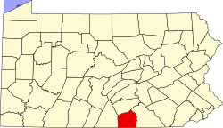
Guldens, Pennsylvania

Last updated

Guldens
USA Pennsylvania location map.svg
Red pog.svg
Guldens
Location in Pennsylvania.
Usa edcp location map.svg
Red pog.svg
Guldens
Guldens (the United States)
Coordinates: 39°51′30″N77°08′20″W / 39.85833°N 77.13889°W / 39.85833; -77.13889
CountryFlag of the United States.svg  United States
State Flag of Pennsylvania.svg  Pennsylvania
County Adams
Elevation
[1]
581 ft (177 m)
Time zone UTC-5 (Eastern (EST))
  Summer (DST) UTC-4 (EDT)
Area codes 717 & 223
GNIS feature ID1176302

Guldens is an unincorporated community in Straban Township, Adams County, Pennsylvania, United States. [2] It is located off U.S. Route 30, approximately five miles east of Gettysburg.

Related Research Articles

<span class="mw-page-title-main">Adams County, Pennsylvania</span> County in Pennsylvania, United States

Adams County is a county in the Commonwealth of Pennsylvania. As of the 2020 census, the population was 103,852. Its county seat is Gettysburg. The county was created on January 22, 1800, from part of York County, and was named for the second President of the United States, John Adams. On July 1–3, 1863, a crucial battle of the American Civil War was fought near Gettysburg; Adams County as a result is a center of Civil War tourism.

Gulden is the historical German and Dutch term for gold coin, equivalent to the English term guilder.

<span class="mw-page-title-main">Adams Township, Snyder County, Pennsylvania</span> Township in Pennsylvania, United States

Adams Township in Snyder County, Pennsylvania, United States, is a township which had a population of 907 at the 2010 census. Per the US Census Bureau, by 2020 the population had reduced to 895 people.

<span class="mw-page-title-main">Pennsylvania's 4th congressional district</span> U.S. House district for Pennsylvania

Pennsylvania's fourth congressional district, effective January 3, 2023, encompasses the majority of Montgomery County and most of Berks County northeast of Reading in southeastern Pennsylvania. In the 2020 redistricting cycle, the Pennsylvania district pushed northwards, further into Berks County, effective with the 2022 elections. The area has been represented by Democrat Madeleine Dean since 2019.

<span class="mw-page-title-main">Rock Creek (Monocacy River tributary)</span> River in Pennsylvania, United States

Rock Creek is an 18.9-mile-long (30.4 km) tributary of the Monocacy River in south-central Pennsylvania and serves as the border between Cumberland and Mount Joy townships. Rock Creek was used by the Underground Railroad and flows near several Gettysburg Battlefield sites, including Culp's Hill, the Benner Hill artillery location, and Barlow Knoll.

<span class="mw-page-title-main">Conewago Creek (west)</span> Tributary of the Susquehanna River in Pennsylvania, United States

Conewago Creek is an 80.2-mile-long (129.1 km) tributary of the Susquehanna River in Adams and York counties in Pennsylvania in the United States, with its watershed also draining a small portion of Carroll County, Maryland. The source is at an elevation of 1,440 feet (440 m), east of Caledonia State Park, in Franklin Township in Adams County. The mouth is the confluence with the Susquehanna River at York Haven in York County at an elevation of 259 feet (79 m).

<span class="mw-page-title-main">Prouty Place State Park</span> Park in Pennsylvania, United States of America

Prouty Place State Park is a Pennsylvania state park on 5 acres (2 ha) in Summit Township, Potter County, Pennsylvania in the United States. The park is 5 miles (8 km) southwest of Pennsylvania Route 44, along Prouty Road near the junction with Long Toe Road, near Sweden Valley. The park provides access points for hiking, hunting and fishing in the Susquehannock State Forest. It is a small rest area for hikers and other travellers to the wilds of Potter County.

<span class="mw-page-title-main">Mont Alto State Park</span>

Mont Alto State Park is a Pennsylvania state park on 24 acres (9.7 ha) in Quincy Township, Franklin County, Pennsylvania in the United States. The park is on Pennsylvania Route 233 one mile from Mont Alto.

<span class="mw-page-title-main">Big Spring State Park (Pennsylvania)</span> State park in Perry County, Pennsylvania

Big Spring State Park is a 45-acre (18 ha) Pennsylvania state park in Toboyne Township, Perry County, Pennsylvania in the United States. The park is on Pennsylvania Route 274, 5.5 miles (8.9 km) southwest of New Germantown. Big Spring State Park is a hiking and picnic area. A partially completed railroad tunnel in Conococheague Mountain is a feature of the park.

<span class="mw-page-title-main">Fowlers Hollow State Park</span> State park in Perry County, Pennsylvania, United States

Fowlers Hollow State Park is a 104-acre (42 ha) Pennsylvania state park in Toboyne Township, Perry County, Pennsylvania in the United States. The park is 0.25 miles (400 m) from Blain just off Pennsylvania Route 274. Fowlers Hollow State Park is on the site of a former sawmill, and was developed as a park by the Works Progress Administration during the Great Depression.

<span class="mw-page-title-main">Linn Run State Park</span> State park in Westmoreland County, Pennsylvania

Linn Run State Park is a Pennsylvania state park on 612 acres (248 ha) in Cook and Ligonier Townships, Westmoreland County, Pennsylvania in the United States. The park borders Forbes State Forest. Two smaller streams, Grove Run and Rock Run, join in Linn Run State Park to form Linn Run which has a waterfall, Adams Falls, which can be seen at the park. This state park is just off Pennsylvania Route 381 near the small town of Rector.

The 12th Pennsylvania House of Representatives District is in western Pennsylvania and, as of 2023, is represented by Republican Stephenie Scialabba.

<span class="mw-page-title-main">Pennsylvania Route 134</span> State highway in Adams County, Pennsylvania, US

Pennsylvania Route 134 (PA 134), also called Taneytown Road, is a north–south, two-lane state highway in Adams County, Pennsylvania. It runs from the Maryland border at the Mason–Dixon line in Mount Joy Township north to U.S. Route 15 Business in Gettysburg. PA 134 runs through farmland between the Maryland border and an interchange with the US 15 freeway. North of here, the route passes through Round Top and serves Gettysburg National Military Park before reaching its northern terminus. Taneytown Road was created in 1800 to connect Gettysburg with Taneytown, Maryland. The road was used during the 1863 Battle of Gettysburg for the procession to the cemetery consecration at which the Gettysburg Address was delivered. PA 134 was designated to its current alignment in 1928, with the section north of Round Top paved. The southern portion of the route was paved in the 1930s.

<span class="mw-page-title-main">National Register of Historic Places listings in Adams County, Pennsylvania</span>

This is a list of the National Register of Historic Places listings in Adams County, Pennsylvania.

<span class="mw-page-title-main">Pennsylvania House of Representatives, District 139</span> American legislative district

The 139th Pennsylvania House of Representatives District is located in Northeastern Pennsylvania and has been represented since 2023 by Joseph Adams.

Knoxlyn is an unincorporated community situated in Highland Township in Adams County, Pennsylvania, United States. It is located 8 kilometers (5.0 mi) west of Gettysburg between U.S. Route 30 and Pennsylvania Route 116.

Fairplay is a populated place in Adams County, Pennsylvania, United States. It is located between the Gettysburg Battlefield and the Mason–Dixon line at the intersection of U.S. Route 15 and the Emmitsburg Road, near Marsh Creek, in Freedom Township. Moritz' Tavern at the intersection was the site of General John F. Reynolds' headquarters the night before the Battle of Gettysburg.

McAdams is an unincorporated community in Robinson Township, Washington County, Pennsylvania, United States. McAdams is located at the intersection of Pennsylvania Route 980 and North Branch Road, 2.2 miles (3.5 km) west-northwest of McDonald. The community is a coal town which was the site of the Pittsburgh Coal Company's Montour No. 9 mine, which closed in 1954. The Montour Trail passes through the community, as did a branch of the Montour Railroad during the mine's operation.

The Pennsylvania State Game Lands Number 249 are Pennsylvania State Game Lands in northeastern Adams County in Pennsylvania in the United States.

The Pennsylvania State Game Lands Number 259 are Pennsylvania State Game Lands in Armstrong County in Pennsylvania in the United States providing hunting, bird watching, and other activities.

References

  1. "Guldens". Geographic Names Information System . United States Geological Survey, United States Department of the Interior.
  2. General Highway Map: Adams County, Pennsylvania (PDF) (Map). Pennsylvania Department of Transportation. 2018. Retrieved April 29, 2019.