Beechersville, Pennsylvania

Last updated

Beechersville, Pennsylvania
Unincorporated community
USA Pennsylvania location map.svg
Red pog.svg
Beechersville
Coordinates: 39°55′02″N77°17′22″W / 39.91722°N 77.28944°W / 39.91722; -77.28944
Country United States
State Pennsylvania
County Adams
Township Butler
Elevation
640 ft (200 m)
Time zone UTC-5 (Eastern (EST))
  Summer (DST) UTC-4 (EDT)
Area code 717
GNIS feature ID1169115 [1]

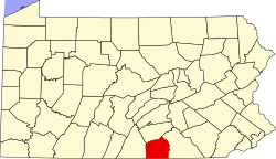
Beechersville is an unincorporated community in Adams County, Pennsylvania, United States. It is located off Cherry Street where Gettysburg Street becomes Mummasburg Road, adjacent to the borough of Arendtsville.

Related Research Articles

<span class="mw-page-title-main">University of Pennsylvania</span> Private university in Philadelphia, Pennsylvania

The University of Pennsylvania, often abbreviated simply as Penn or UPenn, is a private Ivy League research university in Philadelphia. It was one of nine colonial colleges chartered prior to the U.S. Declaration of Independence when Benjamin Franklin, the university's founder and first president, advocated for an educational institution that trained leaders in academia, commerce, and public service. Penn identifies as the fourth-oldest institution of higher education in the United States, though this representation is challenged by other universities. Benjamin Franklin and other Philadelphians established the university in 1749, which would make it the fifth-oldest institution of higher education.

<span class="mw-page-title-main">Pennsylvania Avenue</span> Street in Maryland and Washington, D.C., US

Pennsylvania Avenue is a diagonal street in Washington, D.C., and Prince George's County, Maryland, that connects the White House and the United States Capitol and then crosses Washington, D.C. before entering Maryland. In Maryland, it becomes MD Route 4 and then MD Route 717 in Upper Marlboro, and finally Stephanie Roper Highway.

<span class="mw-page-title-main">Philadelphia</span> Largest city in Pennsylvania, United States

Philadelphia, commonly referred to as Philly, is the most populous city in the Commonwealth of Pennsylvania and the second-most populous city in both the Northeast megalopolis and Mid-Atlantic regions after New York City. It is one of the most historically significant cities in the United States and served as the nation's capital until 1800. Philadelphia is the nation's sixth-most populous city with a population of 1,603,797 as of the 2020 census. Since 1854, the city has been coextensive with Philadelphia County, the most populous county in Pennsylvania, and the urban core of the Delaware Valley, the nation's seventh-largest and one of the world's largest metropolitan regions with 6.245 million residents. Philadelphia is known for its extensive contributions to American history, especially the American Revolution, and for its contemporary influence in business and industry, culture, sports, and music.

<span class="mw-page-title-main">Adams County, Pennsylvania</span> County in Pennsylvania, United States

Adams County is a county in the Commonwealth of Pennsylvania. As of the 2020 census, the population was 103,852. Its county seat is Gettysburg. The county was created on January 22, 1800, from part of York County, and was named for the second President of the United States, John Adams. On July 1–3, 1863, a crucial battle of the American Civil War was fought near Gettysburg; Adams County as a result is a center of Civil War tourism.

<span class="mw-page-title-main">Harrisburg, Pennsylvania</span> Capital city of Pennsylvania, United States

Harrisburg is the capital city of the Commonwealth of Pennsylvania, United States, and the seat of Dauphin County. With a population of 50,135 as of 2021, Harrisburg is the ninth-largest city and 15th-largest municipality in Pennsylvania. Harrisburg is situated on the east bank of the Susquehanna River. It is the larger principal city of the Harrisburg–Carlisle metropolitan statistical area, also known as the Susquehanna Valley, which had a population of 591,712 as of 2020, making it the fourth-most populous metropolitan area in Pennsylvania after the Philadelphia, Pittsburgh, and Lehigh Valley metropolitan areas.

<span class="mw-page-title-main">State College, Pennsylvania</span> Home rule municipality in Pennsylvania, United States

State College is a home rule municipality in Centre County, Pennsylvania, United States. It is a college town, dominated economically, culturally, and demographically by the presence of the University Park campus of Penn State University.

<span class="mw-page-title-main">Chester, Pennsylvania</span> First city in Pennsylvania, United States

Chester is a city in Delaware County, Pennsylvania, United States. It is located in the Delaware Valley on the western bank of the Delaware River between Philadelphia and Wilmington, Delaware. The population of Chester was 32,605 at the 2020 census.

<span class="mw-page-title-main">Erie, Pennsylvania</span> City in Pennsylvania, United States

Erie is a city on the south shore of Lake Erie and the county seat of Erie County, Pennsylvania, United States. Erie is the fifth-largest city in Pennsylvania and the largest city in Northwestern Pennsylvania with a population of 94,831 at the 2020 census. The estimated population in 2023 had decreased to 92,743. The Erie metropolitan area, equivalent to all of Erie County, consists of 266,096 residents. The Erie–Meadville combined statistical area had a population of 369,331 at the 2010 census.

<span class="mw-page-title-main">Allentown, Pennsylvania</span> Home rule municipality in Pennsylvania, United States

Allentown is a city in Lehigh County in the Commonwealth of Pennsylvania, United States. The city had a population of 125,845 at the time of the 2020 census.

<span class="mw-page-title-main">Norristown, Pennsylvania</span> Home rule municipality in Pennsylvania, United States

Norristown is a municipality with home rule status and the county seat of Montgomery County, Pennsylvania, United States, in the Philadelphia metropolitan area. Located along the Schuylkill River, approximately 6 miles (9.7 km) from the Philadelphia city limits, Norristown had a population of 35,748 as of the 2020. It is the fourth most populous municipality in the county and second most populous borough in Pennsylvania.

<span class="mw-page-title-main">Italian Market, Philadelphia</span> Market area in south Philadelphia

The Italian Market is the popular name for the South 9th Street Curb Market, an area of South Philadelphia featuring awning covered sidewalks, curb carts, grocery shops, cafes, restaurants, bakeries, cheese shops, butcher shops, etc., many with an Italian influence. The historical heart of the market is the area of 9th Street between Christian Street and Washington Avenue, the commercial district chartered in 1915, the South Ninth Street Business Men's Association, covered the area between Catharine to Federal and Eighth to Tenth streets, and the market is now generally considered to extend from Fitzwater Street at the north to Wharton Street at the south. The term Italian Market is also used to generally describe the surrounding neighborhood between South Street to the North and Wharton Street to the South running a few blocks to the east and west of 9th street.

<span class="mw-page-title-main">Pennsylvania Academy of the Fine Arts</span> Museum and art school in Philadelphia, Pennsylvania

The Pennsylvania Academy of the Fine Arts (PAFA) is a museum and private art school in Philadelphia, Pennsylvania. It was founded in 1805 and is the first and oldest art museum and art school in the United States.

<span class="mw-page-title-main">Suburban Station</span> Station on the SEPTA Regional Rail

Suburban Station is an art deco office building and underground commuter rail station in Penn Center in Philadelphia. Its official SEPTA address is 16th Street and JFK Boulevard. The station is owned and operated by SEPTA and is one of the three core Center City stations on the SEPTA Regional Rail and one of the busiest stations in the Regional Rail System.

<span class="mw-page-title-main">National Register of Historic Places listings in Pennsylvania</span>

This is a list of properties and districts listed on the National Register of Historic Places in Pennsylvania. As of 2015, there are over 3,000 listed sites in Pennsylvania. All 67 counties in Pennsylvania have listings on the National Register.

<span class="mw-page-title-main">Pennsylvania Route 291</span> State highway in Pennsylvania, US

Pennsylvania Route 291 is an east–west state route in Pennsylvania that runs from U.S. Route 13 and US 13 Business in Trainer, Delaware County, east to Interstate 76 (I-76) in South Philadelphia near the Walt Whitman Bridge and the South Philadelphia Sports Complex. Except for a short 1-mile (1.6 km) section between the western terminus and the Chester/Trainer line, PA 291 is mostly a four-lane highway. From the western terminus to the eastern part of Chester, the route has a concurrency with US 13. It runs parallel to the Delaware River for much of the route. The route passes through industrial areas near the river in Delaware County, serving Chester, Eddystone, Essington, and Lester. PA 291 enters Philadelphia near the Philadelphia International Airport, at which point it has an interchange with I-95. The route crosses the Schuylkill River on the George C. Platt Memorial Bridge and continues along Penrose Avenue to I-76. It has been designated the Industrial Heritage Highway.

<span class="mw-page-title-main">University of Pennsylvania Press</span> Books publisher

The University of Pennsylvania Press, also known as Penn Press, is a university press affiliated with the University of Pennsylvania, an Ivy League university in Philadelphia, Pennsylvania.

<span class="mw-page-title-main">Spring Garden, Philadelphia</span> Historic neighborhood in Pennsylvania, United States

Spring Garden is a neighborhood in central Philadelphia, Pennsylvania, United States, bordering Center City on the north. Spring Garden is a neighborhood that combines diverse residential neighborhoods and significant cultural attractions. The residential areas on the north side of the neighborhood are composed mostly of brick and brownstone three-story townhouses built during the mid-to-late 19th century. The houses include townhouses in the Italianate style, Second Empire, Queen Anne, and Venetian Gothic. Many streets include "terraced" set ups, which include a small gardened plot, often raised, in front of the house. The residential areas to the south are dominated by taller, multi-family buildings built during the 20th century. The museum area, also to the south of Spring Garden Street, includes the Rodin Museum, the Central Library of Philadelphia, and the Barnes Museum. Before consolidation of Philadelphia, Spring Garden was a district of Philadelphia County.

<span class="mw-page-title-main">Pennsylvania School for the Deaf</span> United States historic place

The Pennsylvania School for the Deaf is the third-oldest school of its kind in the United States. Its founder, David G. Seixas (1788–1864), was a Philadelphia crockery maker-dealer who became concerned with the plight of impoverished deaf children who he observed on the city's streets. The current school building is listed by the National Register of Historic Places, and two former campuses are similarly recognized.

<span class="mw-page-title-main">30th Street Station</span> Railway station in Philadelphia, Pennsylvania

30th Street Station, officially William H. Gray III 30th Street Station, is a major intermodal transit station in Philadelphia, Pennsylvania, United States. It is metropolitan Philadelphia's main railroad station and a major stop on Amtrak's Northeast and Keystone corridors. It was named in memory of U.S. representative William H. Gray III in 2020.

References