East Berlin, Pennsylvania

Last updated
East Berlin, Pennsylvania
Borough
East Berlin Log Cabin.JPG
Adams County Pennsylvania incorporated and unincorporated areas East Berlin highlighted.svg
Location in Adams County and the U.S. state of Pennsylvania.
USA Pennsylvania location map.svg
Red pog.svg
East Berlin
Location in Pennsylvania and the United States
Usa edcp location map.svg
Red pog.svg
East Berlin
East Berlin (the United States)
Coordinates: 39°56′16″N76°58′51″W / 39.93778°N 76.98083°W / 39.93778; -76.98083
Country United States
State Pennsylvania
County Adams
Settled1764
Incorporated1879
Government
  TypeBorough Council
Area
[1]
  Total0.73 sq mi (1.89 km2)
  Land0.70 sq mi (1.82 km2)
  Water0.03 sq mi (0.07 km2)
Elevation
443 ft (135 m)
Population
 (2020) [2]
  Total1,542
  Density2,193.46/sq mi (847.27/km2)
Time zone UTC-5 (Eastern (EST))
  Summer (DST) UTC-4 (EDT)
Zip code
17316
Area code(s) 717 and 223
FIPS code 42-20792
Website eastberlinboro.com

East Berlin is a borough in Adams County, Pennsylvania, United States. The population was 1,542 at the 2020 census. [3]

Contents

East Berlin is located in the southern part of Pennsylvania, adjacent to the York County border and 13 miles (21 km) west of York.

History

Pre-colonization and early development

Prior to the arrival of European settlers, the area in what would become East Berlin was inhabited by the Susquehannock Native Americans. As early as 1734, German, Irish, Dutch, and Quaker settlers began occupying land in what would later become Adams County. [4] Following the 1736 signing of a treaty in Philadelphia between Thomas Penn and members of the Six Nations, many settlers began safely moving to the area. [4]

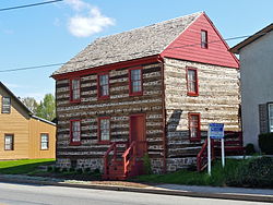
In 1764, John Frankenberger purchased two hundred acres of land from Thomas and Richard Penn, the sons of William Penn. [4] He divided it into eighty-five lots with streets and alleys and named it "Berlin" after Berlin, Germany, then the capital of the Kingdom of Prussia, his native country. Subsequently, confusion with another community in Pennsylvania led to altering the name to "East Berlin." By 1797, under the new owner John Hildebrand, East Berlin had approximately one hundred houses. When York County was divided in 1800, East Berlin became part of the newly created Adams County.

19th Century and the Civil War

For much of its early history, East Berlin was not legally a borough with its own municipal government, but a part of neighboring Hamilton Township; on November 10, 1879, after town residents petitioned the Court of Adams County, 407 acres of land around the community were officially designated as the borough of East Berlin. [4] The town would maintain basic infrastructure like streets, sidewalks, curbs, and oil lamps. The borough built a water reservoir in 1897. Congressman and abolitionist Thaddeus Stevens briefly owned property in East Berlin from 1832 to 1848 before moving to Lancaster. [4]

During the Gettysburg campaign of the Civil War, Jubal Early's Confederate troops marched twice through East Berlin, only a few days before the Battle of Gettysburg would take place. [4] Many residents, aware that the soldiers would pillage and loot for supplies, left milk and other supplies outside their homes, hoping to appease the soldiers. [4] There are other stories of incidents between residents of East Berlin and the Confederate soldiers: after spotting women baking bread in the communal ovens, Confederate soldiers allegedly forced the women to hand over the bread they had made. Other folklore suggests that an unidentified man in the second story of the tavern on King Street shot at the Confederates as they passed through town, and that two families with the name Lincoln from nearby Dover hid in East Berlin after hearing that Confederates would kill anyone they met named "Lincoln." [4] Early himself spent the night at the Zinn farmhouse (named after the woman who owned it) just west of the town on June 27, where he was treated to a variety of Pennsylvania Dutch dishes. [4]

In 1877, the Berlin Branch Railroad was completed, linking the town to Berlin Junction on the Hanover Junction, Hanover and Gettysburg Railroad. The railroad operated until 1914, when the tracks were removed from East Berlin to Abbottstown. The rail line was relaid in 1916 and continued to operate as the East Berlin Railroad until 1939. The tracks were again removed in 1940. [5]

20th Century

In 1921, power lines were constructed in East Berlin, as well as neighboring Abbottstown. 1933 marked the first year that natural gas piping was operational in the town. In the 1950s, the East Berlin Municipal Authority was created, which began to construct a sewage and water treatment facility. Despite some cave-ins during construction of the lines, no major injuries were sustained during its difficult construction, and the project was completed in February 1957. [4]

American diplomat George F. Kennan bought a farm in East Berlin in 1942. Following his work in President Harry S. Truman’s administration, he used it as a secondary home while he worked at the Institute for Advanced Study in Princeton, New Jersey. He owned it until his death in 2005. [4] In 1967, Kennan had his daughter Grace house Svetlana Stalin, the daughter of Joseph Stalin, in their home in East Berlin following her defection to the United States, where she stayed for the summer; Grace admits that the people of East Berlin did not "know they had a mysterious visitor in their midst." [6]

The East Berlin Historic District was added to the National Register of Historic Places in 1985. [7]

Geography

East Berlin is located at 39°56′16″N76°58′51″W / 39.93778°N 76.98083°W / 39.93778; -76.98083 (39.937890, -76.980942). [8]

According to the United States Census Bureau, the borough has a total area of 0.7 square miles (1.8 km2), all land.

East Berlin is at the junction of State highways 194 and 234.

Education

East Berlin is served by the Bermudian Springs School District.

Demographics

Historical population
CensusPop.Note
1820 418
1880 510
1890 59516.7%
1900 66812.3%
1910 6720.6%
1920 616−8.3%
1930 79028.2%
1940 7920.3%
1950 91315.3%
1960 1,03713.6%
1970 1,0864.7%
1980 1,054−2.9%
1990 1,17511.5%
2000 1,36516.2%
2010 1,52111.4%
2020 1,5421.4%
Sources: [9] [10] [11] [2]

As of the census [10] of 2000, there were 1,365 people, 557 households, and 387 families residing in the borough. The population density was 1,962.1 inhabitants per square mile (757.6/km2). There were 588 housing units at an average density of 845.2 per square mile (326.3/km2). The racial makeup of the borough was 97.44% White, 0.51% African American, 0.15% Native American, 0.29% Asian, 0.88% from other races, and 0.73% from two or more races. Hispanic or Latino of any race were 2.86% of the population.

There were 557 households, out of which 34.1% had children under the age of 18 living with them, 56.0% were married couples living together, 10.4% had a female householder with no husband present, and 30.5% were non-families. 26.0% of all households were made up of individuals, and 11.5% had someone living alone who was 65 years of age or older. The average household size was 2.45 and the average family size was 2.95.

In the borough the population was spread out, with 26.4% under the age of 18, 8.1% from 18 to 24, 32.0% from 25 to 44, 18.2% from 45 to 64, and 15.3% who were 65 years of age or older. The median age was 35 years. For every 100 females, there were 86.2 males. For every 100 females age 18 and over, there were 88.0 males.

The median income for a household in the borough was $38,819, and the median income for a family was $43,646. Males had a median income of $34,659 versus $21,971 for females. The per capita income for the borough was $19,818. About 5.7% of families and 6.7% of the population were below the poverty line, including 10.5% of those under age 18 and 5.2% of those age 65 or over.

See also

Related Research Articles

<span class="mw-page-title-main">Adams County, Pennsylvania</span> County in Pennsylvania, United States

Adams County is a county in the Commonwealth of Pennsylvania. As of the 2020 census, the population was 103,852. Its county seat is Gettysburg. The county was created on January 22, 1800, from part of York County, and was named for the second President of the United States, John Adams. On July 1–3, 1863, a crucial battle of the American Civil War was fought near Gettysburg; Adams County as a result is a center of Civil War tourism.

<span class="mw-page-title-main">Abbottstown, Pennsylvania</span> Borough in Pennsylvania, United States

Abbottstown is a borough in Adams County, Pennsylvania, United States. The population was 1,022 at the 2020 census.

<span class="mw-page-title-main">Cumberland Township, Adams County, Pennsylvania</span> Township in Pennsylvania, United States

Cumberland Township is a township in Adams County, Pennsylvania, United States. The population was 7,033 at the 2020 census. In 1863, the American Civil War Battle of Gettysburg took place mainly in Cumberland Township, which surrounds the borough of Gettysburg on three sides.

<span class="mw-page-title-main">Germany Township, Pennsylvania</span> Township in Pennsylvania, United States

Germany Township is a township in Adams County, Pennsylvania, United States. The population was 2,844 at the 2020 census. The majority of early settlers were from Germany and Great Britain.

<span class="mw-page-title-main">Hamilton Township, Adams County, Pennsylvania</span> Township in Pennsylvania, United States

Hamilton Township is a township in Adams County, Pennsylvania, United States. The population was 2,714 at the 2020 census.

<span class="mw-page-title-main">Latimore Township, Pennsylvania</span> Township in Pennsylvania, United States

Latimore Township is a township in Adams County, Pennsylvania, United States. The population was 2,580 at the 2010 census.

<span class="mw-page-title-main">New Oxford, Pennsylvania</span> Borough in Pennsylvania, United States

New Oxford is a borough in Adams County, Pennsylvania, United States. The population was 1,868 at the 2020 census.

<span class="mw-page-title-main">Straban Township, Pennsylvania</span> Township in Pennsylvania, United States

Straban Township is a township in Adams County, Pennsylvania, United States. The population was 4,928 at the 2010 census.

<span class="mw-page-title-main">Adams Township, Butler County, Pennsylvania</span> Township in Pennsylvania, United States

Adams Township in Butler County, Pennsylvania, United States, is a township that had population of 14,841 at the 2020 census.

<span class="mw-page-title-main">Fairview Township, Butler County, Pennsylvania</span> Township in Pennsylvania, United States

Fairview Township is a township in Butler County, Pennsylvania, United States. The population was 1,942 at the 2020 census.

<span class="mw-page-title-main">Valencia, Pennsylvania</span> Borough in Pennsylvania, United States

Valencia is a borough in Butler County, Pennsylvania, United States. The population was 551 at the 2010 census.

<span class="mw-page-title-main">Elverson, Pennsylvania</span> Borough in Pennsylvania, United States

Elverson is a borough in Chester County, Pennsylvania, United States. The population was 1,332 at the 2020 census.

<span class="mw-page-title-main">Mechanicsburg, Pennsylvania</span> Borough in Pennsylvania, United States

Mechanicsburg is a borough in Cumberland County, Pennsylvania, United States. The borough is eight miles (13 km) west of Harrisburg. It is part of the Harrisburg–Carlisle metropolitan statistical area. As of the 2010 census, it had a population of 8,981. The 2020 census reported the population at 9,311.

<span class="mw-page-title-main">Greencastle, Pennsylvania</span> Borough in Pennsylvania, United States

Greencastle is a borough in Franklin County in south-central Pennsylvania, United States. The population was 4,251 at the 2020 census. Greencastle lies within the Cumberland Valley of Pennsylvania.

<span class="mw-page-title-main">Berlin, Pennsylvania</span> Borough in Pennsylvania, United States

Berlin is a borough located approximately 75 miles southeast of Pittsburgh in Somerset County, Pennsylvania, United States. The population was 2,004 at the 2020 census. It is part of the Johnstown, Pennsylvania Metropolitan Statistical Area.

<span class="mw-page-title-main">Garrett, Pennsylvania</span> Borough in Pennsylvania, United States

Garrett is a borough in Somerset County, Pennsylvania, United States. It is part of the Johnstown, Pennsylvania, Metropolitan Statistical Area. The population was 416 at the 2020 census.

<span class="mw-page-title-main">Dillsburg, Pennsylvania</span> Borough in Pennsylvania, United States

Dillsburg is a borough in York County, Pennsylvania, United States. The population was 2,643 as of the 2020 census.

<span class="mw-page-title-main">Hallam, Pennsylvania</span> Borough in Pennsylvania, United States

HallamHEL-əm is a borough in York County, Pennsylvania, United States. The population was 2,774 at the 2020 census.

<span class="mw-page-title-main">Hanover, Pennsylvania</span> Borough in Pennsylvania, United States

Hanover is a borough in York County, Pennsylvania, United States, 19 miles (31 km) southwest of York and 54 miles (87 km) north-northwest of Baltimore, Maryland and is 5 miles (8.0 km) north of the Mason-Dixon line. The town is situated in a productive agricultural region. The population was 16,429 at the 2020 census. The borough is served by the 717 area code and the ZIP Codes of 17331–34. Hanover is named after the German city of Hannover.

<span class="mw-page-title-main">West Manchester Township, Pennsylvania</span> Township in Pennsylvania, United States

West Manchester Township is a township in York County, Pennsylvania, United States. The population was 19,217 at the 2020 census.

References

  1. "ArcGIS REST Services Directory". United States Census Bureau. Retrieved October 12, 2022.
  2. 1 2 "Census Population API". United States Census Bureau. Retrieved Oct 12, 2022.
  3. "Explore Census Data". data.census.gov.
  4. 1 2 3 4 5 6 7 8 9 10 11 The Wheels of Time II. 2014. ISBN   978-1-63452-297-7.
  5. Taber, Thomas T., III (1987). Railroads of Pennsylvania Encyclopedia and Atlas. Thomas T. Taber III. p. 6. ISBN   0-9603398-5-X.{{cite book}}: CS1 maint: multiple names: authors list (link)
  6. Kennan Warnecke, Grace (April 29, 2018). "My Secret Summer with Stalin's Daughter". Politico . Archived from the original on Dec 5, 2022.
  7. "National Register Information System  East Berlin Historic District (#85002693)". National Register of Historic Places . National Park Service. July 9, 2010.
  8. "US Gazetteer files: 2010, 2000, and 1990". United States Census Bureau. 2011-02-12. Retrieved 2011-04-23.
  9. "Census of Population and Housing". U.S. Census Bureau. Retrieved 11 December 2013.
  10. 1 2 "U.S. Census website". United States Census Bureau . Retrieved 2008-01-31.
  11. "Incorporated Places and Minor Civil Divisions Datasets: Subcounty Resident Population Estimates: April 1, 2010 to July 1, 2012". Population Estimates. U.S. Census Bureau. Archived from the original on 11 June 2013. Retrieved 11 December 2013.