Arendtsville, Pennsylvania | |
---|---|
Borough | |
Coordinates: 39°55′28″N77°17′30″W / 39.92444°N 77.29167°W Coordinates: 39°55′28″N77°17′30″W / 39.92444°N 77.29167°W | |
Country | United States |
State | Pennsylvania |
County | Adams |
Settled | 1810 |
Incorporated | 1896 |
Government | |
• Type | Borough Council |
Area | |
• Total | 0.80 sq mi (2.07 km2) |
• Land | 0.80 sq mi (2.07 km2) |
• Water | 0.00 sq mi (0.00 km2) |
Elevation | 702 ft (214 m) |
Population | |
• Total | 867 |
• Density | 1,082.40/sq mi (418.04/km2) |
Time zone | UTC-5 (Eastern (EST)) |
• Summer (DST) | UTC-4 (EDT) |
Zip Code | 17303 |
Area code | 717 |
FIPS code | 42-02928 |
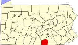
Arendtsville is a borough in Adams County, Pennsylvania. The borough lies on Pennsylvania Route 234 and it is well known for its annual Apple Harvest Festival in the fall. The population was 867 at the 2020 census. [3]
Arendtsville was named for John Arendt, an early settler. [4]
Arendtsville is located at 39°55′28″N77°17′50″W / 39.92444°N 77.29722°W (39.924548, -77.297132). [5] According to the U.S. Census Bureau, the borough has a total area of 0.8 square miles (2.1 km2).
The borough is located near South Mountain, the northern extension of the Blue Ridge Mountain Range.
Historical population | |||
---|---|---|---|
Census | Pop. | %± | |
1880 | 248 | — | |
1900 | 393 | — | |
1910 | 383 | −2.5% | |
1920 | 358 | −6.5% | |
1930 | 338 | −5.6% | |
1940 | 381 | 12.7% | |
1950 | 409 | 7.3% | |
1960 | 588 | 43.8% | |
1970 | 589 | 0.2% | |
1980 | 600 | 1.9% | |
1990 | 693 | 15.5% | |
2000 | 848 | 22.4% | |
2010 | 952 | 12.3% | |
2020 | 867 | −8.9% | |
Sources: [6] [7] [2] |
As of the census [8] of 2000, there were 848 people, 329 households, and 242 families residing in the borough. The population density was 1,221.0 people per square mile (474.5/km²). There were 340 housing units at an average density of 489.5 per square mile (190.3/km²). The racial makeup of the borough was 88.80% White, 1.30% African American, 0.12% Native American, 0.24% Asian, 8.61% from other races, and 0.94% from two or more races. Hispanic or Latino of any race were 16.04% of the population.
There were 329 households, out of which 39.2% had children under the age of 18 living with them, 59.3% were married couples living together, 8.2% had a female householder with no husband present, and 26.4% were non-families. 22.8% of all households were made up of individuals, and 13.1% had someone living alone who was 65 years of age or older. The average household size was 2.58 and the average family size was 3.01.
In the borough the population was spread out, with 29.5% under the age of 18, 6.6% from 18 to 24, 29.2% from 25 to 44, 19.2% from 45 to 64, and 15.4% who were 65 years of age or older. The median age was 34 years. For every 100 females there were 101.4 males. For every 100 females age 18 and over, there were 98.0 males.
The median income for a household in the borough was $41,087, and the median income for a family was $43,889. Males had a median income of $28,828 versus $27,813 for females. The per capita income for the borough was $18,256. About 6.3% of families and 10.6% of the population were below the poverty line, including 17.8% of those under age 18 and 1.7% of those age 65 or over.
The borough is served by the Upper Adams School District. Located in Arendtsville is the district's intermediate school, Upper Adams Intermediate School.
Woodlawn is a census-designated place in Alamance County, North Carolina, United States.
Bendersville is a borough in Adams County, Pennsylvania. The population was 641 at the 2010 census.
Biglerville is a borough in Adams County, Pennsylvania. The population was 1,225 at the 2020 census. The National Apple Museum is located on West Hanover St. in Biglerville. The borough is home to Biglerville High School.
Bonneauville is a borough in Adams County, Pennsylvania. The population was 1,758 at the 2020 census.
Carroll Valley is a borough in Adams County, Pennsylvania. The population was 3,940 at the 2020 census.
Conewago Township is a township in Adams County, Pennsylvania, United States. The population was 7,085 at the 2010 census.
Fairfield is a borough in Adams County, Pennsylvania, United States. The population was 507 at the 2010 census.
Huntington Township is a rural township in Adams County, Pennsylvania, United States. The population was 2,369 at the 2010 census.
Latimore Township is a township in Adams County, Pennsylvania, United States. The population was 2,580 at the 2010 census.
Littlestown is a borough in Adams County, Pennsylvania. The population was 4,434 at the 2010 census.
McSherrystown is a borough in Adams County, Pennsylvania, United States. The population was 3,038 as of the 2010 census.
Midway is an unincorporated census-designated place in Adams County, Pennsylvania, United States. The population was 2,125 at the 2010 census.
New Oxford is a borough in Adams County, Pennsylvania, United States. The population was 1,783 at the 2010 census.
Union Township is a township in Adams County, Pennsylvania, United States. The population was 3,148 at the 2010 census.
York Springs is a borough in Adams County, Pennsylvania, United States. The population was 833 at the 2010 census. York Springs is served by the Bermudian Springs School District.
Howard is a borough in Centre County, Pennsylvania, United States. It is part of the State College, Pennsylvania Metropolitan Statistical Area. The population was 720 at the 2010 census.
Liberty is a small borough in Tioga County, Pennsylvania, United States. The population was 232 at the 2020 census.
Bear Lake is a borough in Warren County, Pennsylvania, United States. The population was 193 at the 2000 census.
Cross Roads is a borough in York County, Pennsylvania, United States. The population was 524 at the 2020 census. The cross roads in the borough is where Church Road intersects Cross Roads Avenue and are joined by Century Farms Road. East of the intersection Century Farms Road is numbered SR 2050 and Church Road is unnumbered.
Tunnelhill is a borough that is located in both Cambria and Blair counties in Pennsylvania in the United States. The population was 363 at the 2010 census. Of this, 245 were in Cambria County, and 118 were in Blair County. It is part of the Altoona, PA Metropolitan Statistical Area. Tunnelhill is named after the many railroad tunnels of the Pennsylvania Railroad near here known as the Gallitzin Tunnels.