Freedom Township, Adams County, Pennsylvania

Last updated

Freedom Township,
Adams County,
Pennsylvania
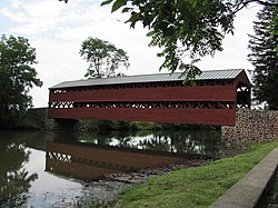
Sachs Covered Bridge.jpg
Adams County Pennsylvania incorporated and unincorporated areas Freedom highlighted.svg
Location in Adams County and the state of Pennsylvania.
Country United States
State Pennsylvania
County Adams
Settled1739
Incorporated1838
Area
[1]
  Total14.02 sq mi (36.30 km2)
  Land13.95 sq mi (36.14 km2)
  Water0.07 sq mi (0.17 km2)
Population
 (2020) [2]
  Total822
  Estimate 
(2023) [2]
835
  Density60.13/sq mi (23.22/km2)
Time zone UTC-5 (Eastern (EST))
  Summer (DST) UTC-4 (EDT)
Area code 717
FIPS code 42-001-27704
Website http://www.freedomtownship.us/

Freedom Township is a township in Adams County, Pennsylvania, United States. The population was 822 at the 2020 census. [2]

Contents

A portion of Eisenhower National Historic Site extends into Freedom Township. [3]

Geography

According to the United States Census Bureau, the township has a total area of 14.0 square miles (36.3 km2), of which 13.9 square miles (36.1 km2) is land and 0.077 square miles (0.2 km2), or 0.47%, is water. [4]

Demographics

Historical population
CensusPop.Note
2000 844
2010 831−1.5%
2020 822−1.1%
2023 (est.)835 [2] 1.6%
U.S. Decennial Census [5]

As of the census [6] of 2000, there were 844 people, 328 households, and 247 families residing in the township. The population density was 60.7 inhabitants per square mile (23.4/km2). There were 376 housing units at an average density of 27.0 per square mile (10.4/km2). The racial makeup of the township was 97.27% White, 0.71% African American, 0.59% Asian, 0.47% from other races, and 0.95% from two or more races. Hispanic or Latino of any race were 1.78% of the population.

There were 328 households, out of which 29.3% had children under the age of 18 living with them, 68.3% were married couples living together, 5.5% had a female householder with no husband present, and 24.4% were non-families. 18.0% of all households were made up of individuals, and 5.2% had someone living alone who was 65 years of age or older. The average household size was 2.57 and the average family size was 2.97.

In the township the population was spread out, with 22.2% under the age of 18, 7.0% from 18 to 24, 24.9% from 25 to 44, 36.7% from 45 to 64, and 9.2% who were 65 years of age or older. The median age was 42 years. For every 100 females there were 100.0 males. For every 100 females age 18 and over, there were 100.9 males.

The median income for a household in the township was $47,778, and the median income for a family was $52,188. Males had a median income of $33,214 versus $25,125 for females. The per capita income for the township was $23,005. About 3.6% of families and 6.3% of the population were below the poverty line, including 3.8% of those under age 18 and 12.7% of those age 65 or over.

Education

It is in the Gettysburg Area School District. [7] The district's comprehensive middle and high schools are Gettysburg Area Middle School and Gettysburg Area High School.

Related Research Articles

<span class="mw-page-title-main">Lake Township, Missaukee County, Michigan</span> Civil township in Michigan, United States

Lake Township is a civil township of Missaukee County in the U.S. state of Michigan. The population was 2,827 at the 2020 census, which makes it the county's most-populated municipality.

<span class="mw-page-title-main">Aspers, Pennsylvania</span> Census-designated place in Pennsylvania, United States

Aspers is a census-designated place in Menallen Township, Adams County, Pennsylvania, United States. As of the 2020 census, it had a population of 486. At the 2000 census it was listed as the Bendersville Station-Aspers CDP.

<span class="mw-page-title-main">Cashtown-McKnightstown, Pennsylvania</span> CDP in Pennsylvania, United States

Cashtown-McKnightstown was a census-designated place (CDP) in Franklin Township, Adams County, Pennsylvania. It was the 2000 United States Census area designated by obsolete Census Code 11588 and has been replaced by the CDPs of Cashtown and McKnightstown, which the USGS designated as separate named places on August 30, 2010.

<span class="mw-page-title-main">Cumberland Township, Adams County, Pennsylvania</span> Township in Pennsylvania, United States

Cumberland Township is a township in Adams County, Pennsylvania, United States. The population was 7,031 at the 2020 census. In 1863, the American Civil War Battle of Gettysburg took place mainly in Cumberland Township, which surrounds the borough of Gettysburg on three sides.

<span class="mw-page-title-main">Franklin Township, Adams County, Pennsylvania</span> Township in Pennsylvania, United States

Franklin Township is a township in Adams County, Pennsylvania, United States. The population was 4,671 at the 2020 census.

<span class="mw-page-title-main">Germany Township, Pennsylvania</span> Township in Pennsylvania, United States

Germany Township is a township in Adams County, Pennsylvania, United States. The population was 2,845 at the 2020 census.The majority of early settlers were from Germany and Great Britain.

<span class="mw-page-title-main">Hamilton Township, Adams County, Pennsylvania</span> Township in Pennsylvania, United States

Hamilton Township is a township in Adams County, Pennsylvania, United States. The population was 2,712 at the 2020 census.

<span class="mw-page-title-main">Lake Heritage, Pennsylvania</span> Census-designated place in Pennsylvania, United States

Lake Heritage is a census-designated place (CDP) in Adams County, Pennsylvania, United States. Its population was 2,158 at the 2020 census.

<span class="mw-page-title-main">Latimore Township, Pennsylvania</span> Township in Pennsylvania, United States

Latimore Township is a township in Adams County, Pennsylvania, United States. The population was 2,580 at the 2010 census.

<span class="mw-page-title-main">Mount Pleasant Township, Adams County, Pennsylvania</span> Township in Pennsylvania, United States

Mount Pleasant Township is a township that is located in Adams County, Pennsylvania, United States. As of the 2010 census, the township population was 4,693.

<span class="mw-page-title-main">New Oxford, Pennsylvania</span> Borough in Pennsylvania, United States

New Oxford is a borough in Adams County, Pennsylvania, United States. The population was 1,868 at the 2020 census.

<span class="mw-page-title-main">Orrtanna, Pennsylvania</span> Census-designated place in Pennsylvania, United States

Orrtanna is a census-designated place (CDP) in Adams County, Pennsylvania, United States. The population was 183 at the 2020 census.

<span class="mw-page-title-main">Oxford Township, Adams County, Pennsylvania</span> Township in Pennsylvania, United States

Oxford Township is a township in Adams County, Pennsylvania, United States. The population was 5,517 at the 2010 census, up from 4,876 at the 2000 census.

<span class="mw-page-title-main">Straban Township, Pennsylvania</span> Township in Pennsylvania, United States

Straban Township is a township in Adams County, Pennsylvania, United States. The population was 4,928 at the 2010 census.

<span class="mw-page-title-main">Troy Township, Bradford County, Pennsylvania</span> Township in Pennsylvania, United States

Troy Township is a township in Bradford County, Pennsylvania. It is part of Northeastern Pennsylvania. The population was 1,645 at the 2010 census. The town's children are assigned to attend the Troy Area School District.

<span class="mw-page-title-main">Clearfield Township, Butler County, Pennsylvania</span> Township in Pennsylvania, United States

Clearfield Township is a township in Butler County, Pennsylvania, United States. The population was 2,430 at the 2020 census.

<span class="mw-page-title-main">Harris Township, Pennsylvania</span> Township in Pennsylvania, United States

Harris Township is a township in Centre County, Pennsylvania, United States. It is part of the State College, Pennsylvania Metropolitan Statistical Area. Boalsburg, a census-designated place (CDP), is located within the township. The population was 4,873 at the 2010 census, which is a 4.6% increase since the 2000 census.

<span class="mw-page-title-main">Ridgway Township, Pennsylvania</span> Township in Pennsylvania, United States

Ridgway Township is a township in Elk County, Pennsylvania, United States. The population was 2,424 at the 2020 census, down from 2,523 in 2010, down from 2,802 at the 2000 census.

<span class="mw-page-title-main">Perry Township, Fayette County, Pennsylvania</span> Township in Pennsylvania, United States

Perry Township is a township in Fayette County, Pennsylvania, United States. The population was 2,339 at the 2020 census, a decline from the figure of 2,552 tabulated in 2010. The Frazier School District serves the township.

<span class="mw-page-title-main">Cherrytree Township, Pennsylvania</span> Township in Pennsylvania, United States

Cherrytree Township is a township in Venango County, Pennsylvania, United States. The population was 1,306 at the 2020 census, a decrease from 1,973 in 2010. It is part of Titusville.

References

  1. "2016 U.S. Gazetteer Files". United States Census Bureau. Retrieved August 11, 2017.
  2. 1 2 3 4 Bureau, US Census. "City and Town Population Totals: 2020-2023". Census.gov. US Census Bureau. Retrieved October 30, 2024.{{cite web}}: |last1= has generic name (help)
  3. "2020 CENSUS - CENSUS BLOCK MAP: Freedom township, PA" (PDF). U.S. Census Bureau . Retrieved October 19, 2024. Eisenhower Natl Hist Sit
    See also: "Maps". Eisenhower National Historic Site . Retrieved October 19, 2024.
  4. "Geographic Identifiers: 2010 Demographic Profile Data (G001): Freedom township, Adams County, Pennsylvania". U.S. Census Bureau, American Factfinder. Archived from the original on February 12, 2020. Retrieved July 18, 2013.
  5. "Census of Population and Housing". Census.gov. Retrieved June 4, 2016.
  6. "U.S. Census website". United States Census Bureau . Retrieved January 31, 2008.
  7. "2020 CENSUS - SCHOOL DISTRICT REFERENCE MAP: Adams County, PA" (PDF). U.S. Census Bureau . Retrieved October 19, 2024. - Text list

39°45′59″N77°17′53″W / 39.76639°N 77.29806°W / 39.76639; -77.29806