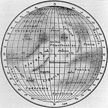
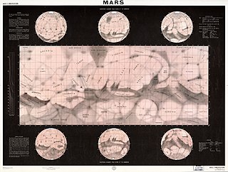
List of albedo features on Mercury

Last updated

A 1934 map showing some of Mercury's albedo features Mercure carte antoniadi.jpg
A 1934 map showing some of Mercury's albedo features

This is a list of the albedo features of the planet Mercury as seen by early telescopic observation.

Early telescopic observations of Mercury were based on the assumption that Mercury keeps one of its faces permanently turned toward the Sun, through the mechanism of tidal locking. Although this is not true (Mercury rotates three times on its axis for every two revolutions around the Sun), when it is positioned for best viewing from Earth, the amount by which its visible face has rotated from its previous best viewing position is fairly small.

A map of Mercury [1] made in the 1910s by astronomer Eugène Michel Antoniadi shows the following albedo features, localized by a grid in which 0° longitude is the (assumed) subsolar meridian. No certain connection has been made between these features and the topographic features viewed on Mercury by the Mariner 10 spacecraft. Mariner 10, however, imaged less than half of Mercury's surface.

The names are drawn from Greek mythology, and often allude to myths about Hermes, the Greek equivalent of the Roman god Mercury.

List of albedo features on Mercury

Name Pronunciation LocationMeaning of name
Admeti Vallis /ædˈmtˈvælɪs/ Dark area in the NE quadrant, between Aurora and Pleias"valley of Admetus"
Apollonia /ˌæpəˈlniə/ Light area near the north pole"land of Apollo"
Argyritis /ˌɑːrɪˈrtɪs/ Light area in the NE quadrant, about 30° N"silver-bearing land"
Aurora /ɒˈrɔːrə/ Light area, 20-30° N, near the eastern terminator Aurora, the Roman goddess of dawn
Caduceata /kəˌdjʃˈtə/ Light area in the NE quadrant, north of 50° N"possessing the caduceus"
Cyllene /sɪˈlni/ Light area in the SW quadrant, extending from about 20° to 50° S Cyllene, birthplace of Hermes
Helii Promontorium /ˈhliˌprɒmənˈtɔːriəm/ A feature close to the zero meridian, about 20° SMeans "cape of Helios"
Heliocaminus /ˌhliəkəˈmnəs/ Light region in the northern hemisphere, between Phaëthontias and Liguria"chamber exposed to the sun"; the region is close to the (assumed) sub-solar point
Hesperis /ˈhɛspərɪs/ Light region in the SW quadrant, between 10° and 40° S, near the western terminator"one of the Hesperides"
Horarum Vallis /hɒˈrɛərəmˈvælɪs/ Dark narrow area in the eastern hemisphere, crossing the Equator SE of Pleias"valley of the Hours"
Ixionis Vallis /ɪkˈsənɪsˈvælɪs/ Band connecting Solitudo Atlantis and Solitudo Criophori, in SW quadrant between the Equator and 30° S"valley of Ixion"
Liguria /lɪˈɡjʊəriə/ Light area in the southern hemisphere, centered slightly west of the zero meridian, at about 40° N Liguria, a region of Italy
Neptuni Vallis /nɛpˈtjnˈvælɪs/ Dark narrow area in the NE quadrant, NW of Pleias"valley of Neptune"
Pentas /ˈpɛntəs/ Light region in the NW quadrant, between the solitudines of Criophori and Aphrodites, extending between about 10° and 40° N
Phaëthontias /ˌfəˈθɒnʃəs/ Light region in the southern hemisphere, between Pleias and Pieria"land of Phaëthon"
Pieria /pˈɪəriə/ Light region in the SW quadrant, bordering on Hesperis, between the solitudines of Atlantis and Criophori Pieria, a region of Greece
Pleias /ˈpləs/ or /ˈpləs/ Light region in the eastern hemisphere, running across the Equator from SW to NE"one of the Pleiades"
Solitudo Alarum /ˌsɒlɪˈtjdəˈlɛərəm/ Small dark region in the NW quadrant, E of Pentas"desert of wings", associated with Mercury in his role as swift messenger
Solitudo Aphrodites /ˌsɒlɪˈtjdˌæfrəˈdtz/ Dark region in the NW quadrant, between 30° and 60° N"desert of Aphrodite"
Solitudo Argiphontae /ˌsɒlɪˈtjdˌɑːrɪˈfɒnt/ Dark region in the NW quadrant, extending along the terminator from the Equator to about 60° N"desert of Argiphontes"; Argiphontes means "slayer of Argus Panoptes" and is an epithet for Hermes
Solitudo Atlantis /ˌsɒlɪˈtjdætˈlæntɪs/ Dark region in the SW quadrant, between 20° and 50° S"desert of Atlas"
Solitudo Criophori /ˌsɒlɪˈtjdkrˈɒfər/ Dark region mostly in the NW quadrant, near the Equator, extending from about 20° N to the western terminator near the Equator"desert of Criophorus"; Criophorus means "bearer of the ram" and is an epithet for Hermes
Solitudo Dionysi /ˌsɒlɪˈtjdˌdəˈns/ Dark region in the NE quadrant, between Caduceata and Liguria, about 40° S"desert of Dionysus"
Solitudo Hermae Trismegisti /ˌsɒlɪˈtjdˈhɜːrmˌtrɪzmɪˈɪst/ Large medium-albedo region in the SE quadrant, between 30° and 60° S"desert of Thrice-greatest Hermes"
Solitudo Iovis /ˌsɒlɪˈtjdˈvɪs/ Dark region in the SE quadrant, centered about 25° S, 20° E"desert of Jupiter"
Solitudo Ius /ˌsɒlɪˈtjdˈəs/ Dark patch SE of Solitudo Atlantis, in SW quadrant about 50° S"desert of Io"
Solitudo Lycaonis /ˌsɒlɪˈtjdlɪˈkənɪs/ Dark patch near the eastern terminator, centered slightly north of the Equator"desert of Lycaon"
Solitudo Lyrae /ˌsɒlɪˈtjdˈlr/ Small dark patch in the SE quadrant, just south of the Equator, adjoining Neptuni Vallis"desert of the lyre", an instrument associated with Hermes
Solitudo Maiae /ˌsɒlɪˈtjdˈm/ Dark region in the SW quadrant, NE of Cyllene"desert of Maia" (the mother of Hermes)
Solitudo Martis /ˌsɒlɪˈtjdˈmɑːrtɪs/ Dark region in the SE quadrant, about 30°S, 60° E"desert of Mars"
Solitudo Panos /ˌsɒlɪˈtjdˈpnɒs/ Dark region in the southern hemisphere, along the zero meridian between 30° and 50° S"desert of Pan"
Solitudo Persephones /ˌsɒlɪˈtjdpərˈsɛfənz/ Dark region in the SW quadrant, above 60° S, near the terminator"desert of Persephone"
Solitudo Phoenicis /ˌsɒlɪˈtjdfɪˈnsɪs/ Small dark region on the Equator, between 10° and 30° W"desert of the phoenix"
Solitudo Promethei /ˌsɒlɪˈtjdprˈmθ/ Dark region in the SE quadrant, about 70° S, near the eastern terminator"desert of Prometheus"

The names of albedo features currently used by the Gazetteer of Planetary Nomenclature are largely based upon Antoniadi's names, but include several alterations; they also necessarily use a different coordinate grid.

The newer regional names are: Borea ( /ˈbɔːriə/ ) "Northern region"; Australia ( /ɔːˈstrliə/ ) "Southern region"; and Tricrena ( /trɪˈkrnə/ ), the name of a mountain near Pheneus in Arcadia.

Other changes are: all features named Vallis and Promontorium have been renamed Solitudo; Solitudo Argiphontae has been renamed Sinus Argiphontae ("bay of Argiphontes"); Admeti has been changed to Admetei (in error; there is no mythological figure Admeteus); Pleias has become Pleias Gallia.

Notes

Related Research Articles

<span class="mw-page-title-main">Mercury (planet)</span> First planet from the Sun

Mercury is the first planet from the Sun and the smallest planet in the Solar System. It is a terrestrial planet with a heavily cratered surface due to the planet having no geological activity and an extremely tenuous atmosphere. Despite being the smallest planet in the Solar System with a mean diameter of 4,880 km (3,030 mi), 38% of that of Earth's, Mercury is dense enough to have roughly the same surface gravity as Mars. Mercury has a dynamic magnetic field with a strength about 1% of that of Earth's and has no natural satellites.

<span class="mw-page-title-main">Mariner 10</span> 1973 American robotic space probe; flew by Venus and Mercury

Mariner 10 was an American robotic space probe launched by NASA on 3 November 1973, to fly by the planets Mercury and Venus. It was the first spacecraft to perform flybys of multiple planets.

<span class="mw-page-title-main">Martian canals</span> Erroneous idea of canals on Mars

During the late 19th and early 20th centuries, it was erroneously believed that there were "canals" on the planet Mars. These were a network of long straight lines in the equatorial regions from 60° north to 60° south latitude on Mars, observed by astronomers using early telescopes without photography.

<span class="mw-page-title-main">E. M. Antoniadi</span> Greek-French astronomer

Eugène Michel Antoniadi was a Greek-French astronomer.

<span class="mw-page-title-main">Albedo feature</span> Region of a planets surface which contrasts in brightness to its surroundings

In planetary geology, an albedo feature is a large area on the surface of a planet which shows a contrast in brightness or darkness (albedo) with adjacent areas.

<span class="mw-page-title-main">Geology of Mercury</span> Geologic structure and composition of planet Mercury

The geology of Mercury is the scientific study of the surface, crust, and interior of the planet Mercury. It emphasizes the composition, structure, history, and physical processes that shape the planet. It is analogous to the field of terrestrial geology. In planetary science, the term geology is used in its broadest sense to mean the study of the solid parts of planets and moons. The term incorporates aspects of geophysics, geochemistry, mineralogy, geodesy, and cartography.

The classical albedo features of Mars are the light and dark features that can be seen on the planet Mars through an Earth-based telescope. Before the age of space probes, several astronomers created maps of Mars on which they gave names to the features they could see. The most popular system of nomenclature was devised by Giovanni Schiaparelli, who used names from classical antiquity. Today, the improved understanding of Mars enabled by space probes has rendered many of the classical names obsolete for the purposes of cartography; however, some of the old names are still used to describe geographical features on the planet.

The Skinakas basin is the informal name given to a structure on Mercury that appeared to be an extremely large impact basin. The limited-resolution images available showed a double-ringed structure, with the inner ring having a diameter of around 1600 km, which would have made it one of the largest impact basins in the Solar System. It appeared to be even larger than the Caloris basin on Mercury, which has been known since the Mariner 10 flybys of that planet. The part of the outer ring that was imaged appeared to correspond to a diameter of around 2300 km.

<span class="mw-page-title-main">Kuiper (Mercurian crater)</span> Crater on Mercury

Kuiper is a moderate-size crater with a central peak cluster located at 11.35°S 31.23°W on Mercury. It is 62 kilometers in diameter and was named after Dutch-American astronomer Gerard Kuiper in 1976. It is one of only 2 Mercurian craters which are named not after artists, and one of very few cases when the same name is used for 3 craters. Gerard Kuiper, being a leader of American planetary science, died shortly before the first images of Mercurian surface were made.

<span class="mw-page-title-main">Victoria quadrangle</span> Quadrangle on Mercury

The Victoria quadrangle is a region on Mercury from 0 to 90° longitude and 20 to 70 ° latitude. It is designated the "H-2" quadrangle, and is also known as Aurora after a large albedo feature.

<span class="mw-page-title-main">Tolstoj quadrangle</span> Quadrangle on Mercury

The Tolstoj quadrangle in the equatorial region of Mercury runs from 144 to 216° longitude and -25 to 25° latitude. It was provisionally called "Tir", but renamed after Leo Tolstoy by the International Astronomical Union in 1976. Also called Phaethontias.

<span class="mw-page-title-main">Tolstoj (crater)</span> Crater on Mercury

Tolstoj is a large, ancient impact crater on Mercury. It was named after Leo Tolstoy. The albedo feature Solitudo Maiae appears to be associated with this crater.

<span class="mw-page-title-main">Kuiper quadrangle</span> Quadrangle on Mercury

The Kuiper quadrangle, located in a heavily cratered region of Mercury, includes the young, 55-km-diameter crater Kuiper, which has the highest albedo recorded on the planet, and the small crater Hun Kal, which is the principal reference point for Mercurian longitude. Impact craters and basins, their numerous secondary craters, and heavily to lightly cratered plains are the characteristic landforms of the region. At least six multiringed basins ranging from 150 km to 440 km in diameter are present. Inasmuch as multiringed basins occur widely on that part of Mercury photographed by Mariner 10, as well as on the Moon and Mars, they offer a potentially valuable basis for comparison between these planetary bodies.

<span class="mw-page-title-main">Bach quadrangle</span> Quadrangle on Mercury

The Bach quadrangle encompasses the south polar part of Mercury poleward of latitude 65° S. It is named after the prominent crater Bach within the quadrangle, which is in turn named after Baroque composer Johann Sebastian Bach. The quadrangle is now called H-15.

<span class="mw-page-title-main">Neruda quadrangle</span> Quadrangle on Mercury

The Neruda quadrangle (H-13) is one of fifteen quadrangles on Mercury. It runs from 180 to 270° longitude and -20 to -70° latitude. Named after the Neruda crater, it was mapped in detail for the first time after MESSENGER entered orbit around Mercury in 2011. It had not been mapped prior to that point because it was one of the six quadrangles that was not illuminated when Mariner 10 made its flybys in 1974 and 1975. These six quadrangles continued to be known by their albedo feature names, with this one known as the Solitudo Persephones quadrangle.

<span class="mw-page-title-main">History of Mars observation</span> History of observations of the planet Mars

The history of Mars observation is about the recorded history of observation of the planet Mars. Some of the early records of Mars' observation date back to the era of the ancient Egyptian astronomers in the 2nd millennium BCE. Chinese records about the motions of Mars appeared before the founding of the Zhou dynasty. Detailed observations of the position of Mars were made by Babylonian astronomers who developed arithmetic techniques to predict the future position of the planet. The ancient Greek philosophers and Hellenistic astronomers developed a geocentric model to explain the planet's motions. Measurements of Mars' angular diameter can be found in ancient Greek and Indian texts. In the 16th century, Nicolaus Copernicus proposed a heliocentric model for the Solar System in which the planets follow circular orbits about the Sun. This was revised by Johannes Kepler, yielding an elliptic orbit for Mars that more accurately fitted the observational data.

<span class="mw-page-title-main">Nilokeras Scopulus</span> Geologic feature of Mars

Nilokeras Scopulus is a long escarpment (cliff) in the northern hemisphere of the planet Mars. It is located along the southeastern boundary of the Tempe Terra plateau and forms the northern valley wall of the downstream portion of the immense Kasei Valles outflow channel system. The escarpment is 765 km long and ranges from 1 to a little over 2 km (3300–6600 ft) in height.

The following outline is provided as an overview of and topical guide to Mercury: