
Eswatini, officially the Kingdom of Eswatini and also known as Swaziland, is a landlocked country in Southern Africa. It is bordered by Mozambique to its northeast and South Africa to its north, west and south. At no more than 200 kilometres (120 mi) north to south and 130 kilometres (81 mi) east to west, Eswatini is one of the smallest countries in Africa; despite this, its climate and topography are diverse, ranging from a cool and mountainous highveld to a hot and dry lowveld.
Artifacts indicating human activity dating back to the early Stone Age have been found in the Kingdom of Eswatini. Prehistoric rock art paintings date from c. 25,000 B.C. and continuing up to the 19th century can be found in various places around the country.
Mbabane is the capital and largest city in Eswatini. With an estimated population of 94,874 (2010), it is located on the Mbabane River and its tributary the Polinjane River in the Mdzimba Mountains. It is located in the Hhohho Region, of which it is also the capital. The average elevation of the city is 1243 meters. It lies on the MR3 road.

Mswati III is the King of Eswatini and head of the Swazi Royal Family. He was born in Manzini, Eswatini, to King Sobhuza II and one of his younger wives, Ntfombi Tfwala. He was Tfwala’s only child. He attended primary school at Masundvwini Primary School and secondary school at Lozitha Palace School. From 1983 to 1986, he attended Sherborne School in north-west Dorset, England. He was crowned as Mswati III, Ingwenyama and King of Swaziland, on 25 April 1986 at the age of 18, thus becoming the youngest ruling monarch in the world at that time. Together with his mother, Ntfombi Tfwala, now Queen Mother (Ndlovukati), he rules the country as an absolute monarch. Mswati III is known for his practice of polygamy and currently has 15 wives. His policies and lavish lifestyle have led to local protests and international criticism.

The Swazi or Swati are a Bantu ethnic group of Southern Africa, predominantly inhabiting modern Eswatini and South Africa's Mpumalanga province. The Swati are part of the Nguni family that can be archaeologically traced in East Africa where the same tradition, beliefs and cultural practices are found. The Swati share a unique experience, culture and Royal lineage. This lineage is exclusive to the inhabitants of Eswatini, even though there have been more Swazi people that have moved to South Africa and the United Kingdom in the 20th century. The original inhabitants of Eswatini no longer reside in Eswatini as a majority population while some remain in the land. The Swazi people and the Kingdom of Eswatini today are named after Mswati II, who became king in 1839 after the death of his father King Sobhuza who strategically defeated the British who occupied Swaziland. The Kingdom of Swaziland was a region occupied by the San people of Southern Africa and the current Swazis came in from North Eastern regions through to Mozambique and eventually Swaziland in the 15th century. Mixtures with the San people and other Nguni tribes occurred. Their royal lineage can be traced to a chief named Dlamini I; this is still the royal clan name. About three-quarters of the clan groups are Nguni; the remainder are Sotho, Tsonga, others North East African and San descendants. These groups have intermarried freely. There are slight differences among Swazis as a nation with varying features and skin tones yet Swazi identity extends to all those with allegiance to the twin monarchs Ingwenyama "the Lion" and Indlovukati "the She-Elephant". The dominant Swati language and culture are factors that unify Swazis as a nation since there is no other language spoken except for English.

Lobamba is the traditional, spiritual, and legislative capital city of Eswatini, seat of the Parliament, and residence of the Ntombi, the Queen Mother. Mswati III lives about 10 kilometres (6.2 mi) away at the Lozitha Palace. The King and Queen Mother participate in annual December and January Incwala ceremonies and August and September Reed Dancees at the Royal Kraal.
Gandhinagar district is an administrative division of Gujarat, India, whose headquarters are at Gandhinagar, the state capital. It was organized in 1964.

Munger district is one of the thirty-eight districts of Bihar state in eastern India. Munger city is the administrative headquarters of this district. Munger district is a part of Munger Division. Its literacy rate of 73.3% is higher than the state literacy rate of 63.8% and lower than national rate of 74.04.

Patan district is one of the 33 districts of Gujarat state in western India. This district is located in northern Gujarat and bounded by Banaskantha district in the north and northeast, Mehsana district in the east and southeast, Surendranagar district in the south and Kutch District and the Kutch nu Nanu Ran in the west. The district occupies an area of 5792 km².
Ratlam District is a district of Madhya Pradesh state in central India. The town of Ratlam is administrative headquarters of the district.

Jhalawar district is one of the 33 districts of Rajasthan state in western India. The district is bounded on the northwest by Kota district, on the northeast by Baran district, on the east by Guna district of Madhya Pradesh state, on the south by Rajgarh and Shajapur districts of Madhya Pradesh state and on the west by Ratlam, Mandsaur and Nimach districts of Madhya Pradesh state. The district occupies an area of 6928 km². The district is part of Kota division. The historical city of Jhalawar is the administrative headquarters of the district
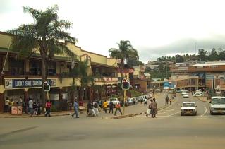
Manzini is a city in Eswatini, which is also the capital of Eswatini's Manzini Region. The city is the country's second largest urban centre behind Mbabane, with a population of 78,000 (2008). It is known as "The Hub" of Eswatini and lies on the MR3 road. Eswatini's primary industrial site at Matsapha lies near the town's western border.

Bathinda district is in Malwa region of Punjab, India. The districts encompasses an area of 3,385 square kilometres. According to area, Bathinda District is the third largest in Punjab. It is bounded by Faridkot district and Moga district on the north, Mukatsar district on the west, Barnala and Mansa districts on the east, and the state of Haryana on the south. Bathinda is cotton producing belt of Punjab.
Tonk District is a district of the state of Rajasthan in western India. The city of Tonk is the administrative headquarters of the district. The district is bounded on the north by Jaipur district, on the east by Sawai Madhopur district, on the southeast by Kota district, on the south by Bundi district, on the southwest by Bhilwara district, and on the west by Ajmer district.
The British office of high commissioner for Southern Africa was responsible for governing British possessions in Southern Africa, latterly the protectorates Basutoland, the Bechuanaland Protectorate and Swaziland, as well as for relations with autonomous governments in the area.
Education in Eswatini begins with pre-school education for infants, primary, secondary and high school education for general education and training (GET) - and universities and colleges at tertiary level.
HIV/AIDS in Eswatini was first reported in 1986 but has since reached epidemic proportions due in large part to cultural beliefs which discourage safe-sex practices. As of 2016, Eswatini has the highest prevalence of HIV among adults aged 15 to 49 in the world (27.2%). The HIV/AIDS epidemic in Eswatini, having contributed largely to high mortality rates among productive Swazi age groups, has adversely affected the country’s socioeconomic status and hindered its overall development.
Prostitution in Eswatini is illegal, the anti-prostitution laws dating back to 1889, when the country Eswatini was a protectorate of South Africa. Law enforcement is inconsistent, particularly near industrial sites and military bases. Police tend to turn a blind eye to prostitution in clubs. There are periodic clamp-downs by the police.

Kasganj district is a district of the Indian state Uttar Pradesh. It is located in the division of Aligarh and consists of Kasganj, Patiali and Sahawar tehsils. Its headquarters is at Kasganj.
As a result of the effects of excess mortality due to AIDS, residents of Eswatini have nearly the lowest documented life expectancy in the world at 58.9 years; only four other countries have lower life expectancies.


