List of airports in Swaziland

Last updated
Map of Swaziland Swaziland-CIA WFB Map.png
Map of Swaziland

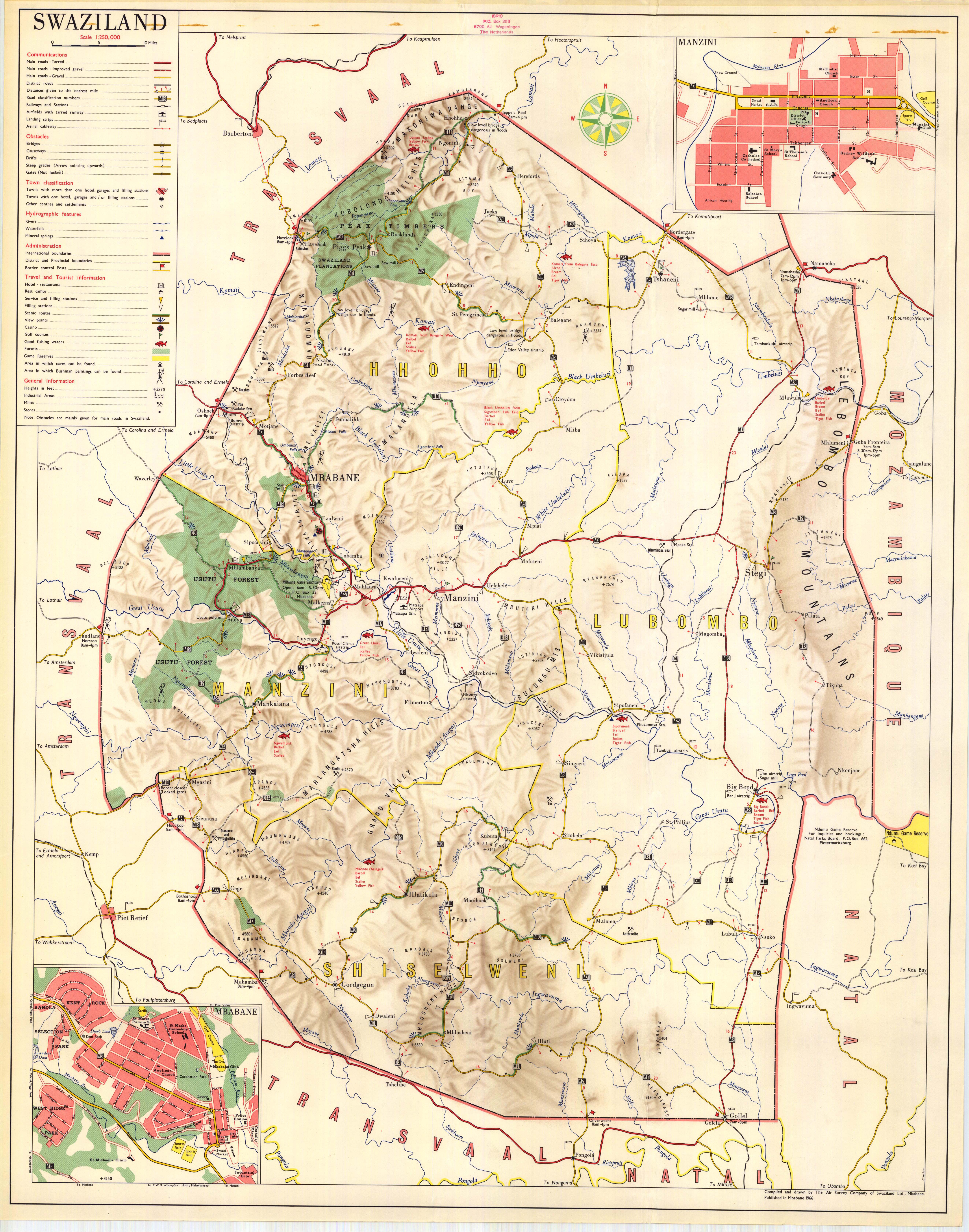
This is a list of airports in Swaziland , sorted by location.

Airport location where aircraft take off and land

An airport is an aerodrome with extended facilities, mostly for commercial air transport. Airports often have facilities to store and maintain aircraft, and a control tower. An airport consists of a landing area, which comprises an aerially accessible open space including at least one operationally active surface such as a runway for a plane to take off or a helipad, and often includes adjacent utility buildings such as control towers, hangars and terminals. Larger airports may have airport aprons, taxiway bridges, air traffic control centres, passenger facilities such as restaurants and lounges, and emergency services. In some countries, the US in particular, they also typically have one or more fixed-base operators, serving general aviation.

Contents

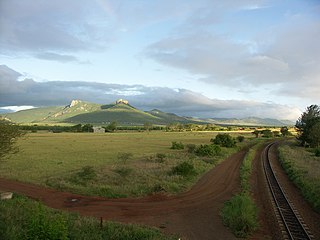
Swaziland, officially the Kingdom of Eswatini, is a landlocked country in southern Africa, bordered to the north, south, east and west by South Africa, and to the east by Mozambique. The nation, as well as its people, are named after the 19th-century king Mswati II. Swaziland is divided into four districts: Hhohho, Lubombo, Manzini, and Shiselweni. The capital of Swaziland is Mbabane, while the country's traditional and legislative capital is Lobamba.

Africa The second largest and second most-populous continent, mostly in the Northern and Eastern Hemispheres

Africa is the world's second largest and second most-populous continent, being behind Asia in both categories. At about 30.3 million km2 including adjacent islands, it covers 6% of Earth's total surface area and 20% of its land area. With 1.2 billion people as of 2016, it accounts for about 16% of the world's human population. The continent is surrounded by the Mediterranean Sea to the north, the Isthmus of Suez and the Red Sea to the northeast, the Indian Ocean to the southeast and the Atlantic Ocean to the west. The continent includes Madagascar and various archipelagos. It contains 54 fully recognised sovereign states (countries), nine territories and two de facto independent states with limited or no recognition. The majority of the continent and its countries are in the Northern Hemisphere, with a substantial portion and number of countries in the Southern Hemisphere.

South Africa Republic in the southernmost part of Africa

South Africa, officially the Republic of South Africa (RSA), is the southernmost country in Africa. It is bounded to the south by 2,798 kilometres (1,739 mi) of coastline of Southern Africa stretching along the South Atlantic and Indian Oceans; to the north by the neighbouring countries of Namibia, Botswana, and Zimbabwe; and to the east and northeast by Mozambique and Eswatini (Swaziland); and it surrounds the enclaved country of Lesotho. South Africa is the largest country in Southern Africa and the 25th-largest country in the world by land area and, with over 57 million people, is the world's 24th-most populous nation. It is the southernmost country on the mainland of the Old World or the Eastern Hemisphere. About 80 percent of South Africans are of Sub-Saharan African ancestry, divided among a variety of ethnic groups speaking different African languages, nine of which have official status. The remaining population consists of Africa's largest communities of European (White), Asian (Indian), and multiracial (Coloured) ancestry.

Mozambique country in Africa

Mozambique, officially the Republic of Mozambique, is a country located in Southeast Africa bordered by the Indian Ocean to the east, Tanzania to the north, Malawi and Zambia to the northwest, Zimbabwe to the west, and Eswatini (Swaziland) and South Africa to the southwest. The sovereign state is separated from the Comoros, Mayotte and Madagascar by the Mozambique Channel to the east. The capital of Mozambique is Maputo while Matola is the largest city, being a suburb of Maputo.

Airports

Names shown in bold indicate the airport has scheduled passenger service on commercial airlines.

Most of the airfields listed below are unpaved. The exceptions are Matsapha Airport and Sikhuphe International Airport.

Matsapha Airport airport

Matsapha Airport is an airport located near Manzini, a city in Manzini District of Eswatini. It serves flights of the Eswatini Government and mercy flights.

Location served ICAO IATA Airport name Runway length/surface Coordinates
Big Bend FDBT Tambuti Airfield 800 m (2,600 ft) Grass 26°44′10″S31°46′35″E / 26.73611°S 31.77639°E / -26.73611; 31.77639 (Tambuti Airfield)
Big Bend FDUB Ubombo Ranches Airfield 730 m (2,400 ft) unpaved 26°46′07″S031°56′12″E / 26.76861°S 31.93667°E / -26.76861; 31.93667 (Ubombo Ranches Airfield)
Bhunya Bhunya Airfield 1,250 m (4,100 ft) Gravel 26°35′0″S30°56′35″E / 26.58333°S 30.94306°E / -26.58333; 30.94306 (Bhunya Airfield)
Kubuta FDKS / FDKB Kubuta Airfield 847 m (2,779 ft) grass 26°52′54″S031°29′23″E / 26.88167°S 31.48972°E / -26.88167; 31.48972 (Kubuta Airfield) [1] [2]
Manzini FDMSMTS Matsapha (International) Airport 2,600 m (8,500 ft) paved 26°31′44″S031°18′27″E / 26.52889°S 31.30750°E / -26.52889; 31.30750 (Matsapha Airport)
Manzini FDSKSHO King Mswati III International Airport 3,600 m (11,800 ft) Asphalt 26°21′24″S31°43′01″E / 26.35667°S 31.71694°E / -26.35667; 31.71694 (King Mswati III Airport)
Mhlume FDMH Mhlume Airfield 709 m (2,326 ft) unpaved 26°01′33″S031°48′36″E / 26.02583°S 31.81000°E / -26.02583; 31.81000 (Mhlume Airfield)
Ngonini FDNG Piggs Peak Airfield 823 m (2,700 ft) unpaved 25°47′53″S031°24′43″E / 25.79806°S 31.41194°E / -25.79806; 31.41194 (Piggs Peak)
Nhlangano FDNH Nhlangano Airfield 671 m (2,201 ft) unpaved 27°07′12″S031°12′45″E / 27.12000°S 31.21250°E / -27.12000; 31.21250 (Nhlangano)
Nsoko FDNS Nsoko Airfield 671 m (2,201 ft) unpaved 27°01′06″S031°56′07″E / 27.01833°S 31.93528°E / -27.01833; 31.93528 (Nsoko Airfield)
Simunye FDSM Simunye Airfield 1,100 m (3,600 ft) unpaved 26°11′46″S031°55′48″E / 26.19611°S 31.93000°E / -26.19611; 31.93000 (Simunye Airfield)
Siteki FDST Siteki Airfield 1,006 m (3,301 ft) unpaved 26°28′19″S031°56′35″E / 26.47194°S 31.94306°E / -26.47194; 31.94306 (Siteki Airfield)
Tambankulu FDTM Tambankulu Airfield 875 m (2,871 ft) unpaved 26°06′22″S031°55′11″E / 26.10611°S 31.91972°E / -26.10611; 31.91972 (Tambankulu Airfield)
Tshaneni FDTS Tshaneni Airfield 756 m (2,480 ft) unpaved 25°59′06″S031°45′07″E / 25.98500°S 31.75194°E / -25.98500; 31.75194 (Tshaneni Airfield)

The airstrip at Tshaneni is not to be confused with "Tshaneni Airport", a planned transportation hub based around the airstrip in Mkuze, a nearby town on the other side of the South African border.[ citation needed ]

Mkuze Place in KwaZulu-Natal, South Africa

Mkuze, also named Mkhuze or uMkhuze is a small town in Northern KwaZulu-Natal, South Africa. It is located approximately 350 km from the city of Durban. It is along the N2 road en route to Johannesburg, Eswatini and Mozambique; between the Mkuze River and Intaba Yemikhovu. Mkuze is some distance from other small towns such as Hluhluwe (50 km), Nongoma (76 km), Pongola (65 km), and Jozini (25 km). Mkuze is the seat of Umkhanyakude District Municipality.

See also

Map all coordinates using: OpenStreetMap  
Download coordinates as: KML  ·  GPX
King Mswati III International Airport

King Mswati III International Airport, originally named Sikhuphe International Airport, is an airport in Eswatini. It replaced Matsapha Airport as the only international airport in Eswatini accepting commercial flights in 2014. It is designed to handle 360,000 passengers per year.

Related Research Articles

Tshaneni Airfield airport in Eswatini

Tshaneni Airfield is an airstrip serving Tshaneni, in Swaziland.

References

The Portable Document Format (PDF) is a file format developed by Adobe in the 1990s to present documents, including text formatting and images, in a manner independent of application software, hardware, and operating systems. Based on the PostScript language, each PDF file encapsulates a complete description of a fixed-layout flat document, including the text, fonts, vector graphics, raster images and other information needed to display it. PDF was standardized as an open format, ISO 32000, in 2008, and no longer requires any royalties for its implementation.

International Civil Aviation Organization Specialised agency of the United Nations

The International Civil Aviation Organization is a specialized agency of the United Nations. It codifies the principles and techniques of international air navigation and fosters the planning and development of international air transport to ensure safe and orderly growth. Its headquarters is located in the Quartier International of Montreal, Quebec, Canada.

UN/LOCODE, the United Nations Code for Trade and Transport Locations, is a geographic coding scheme developed and maintained by United Nations Economic Commission for Europe (UNECE). UN/LOCODE assigns codes to locations used in trade and transport with functions such as seaports, rail and road terminals, airports, Postal Exchange Office and border crossing points. The first issue in 1981 contained codes for 8,000 locations. The version from 2011 contained codes for about 82,000 locations.