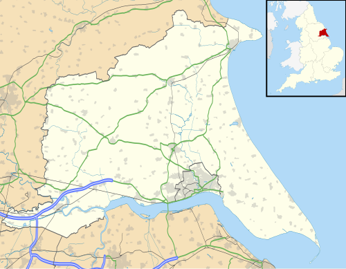
| Name | Status | Former local authority | Map | Refs |
|---|
| Airmyn | Civil parish | Goole Rural District |  | [1] |
| Aldbrough | Civil parish | Holderness Rural District |  | [2] |
| Allerthorpe | Civil parish | Pocklington Rural District |  | [3] |
| Anlaby with Anlaby Common | Civil parish | Haltemprice Urban District |  | [4] |
| Asselby | Civil parish | Howden Rural District |  | [5] |
| Atwick | Civil parish | Holderness Rural District |  | [2] |
| Bainton | Civil parish | Driffield Rural District |  | [6] |
| Barmby Moor | Civil parish | Pocklington Rural District |  | [3] |
| Barmby on the Marsh | Civil parish | Howden Rural District |  | [5] |
| Barmston | Civil parish | Bridlington Rural District |  | [7] |
| Beeford | Civil parish | Driffield Rural District |  | [6] |
| Bempton | Civil parish | Bridlington Rural District |  | [7] |
| Beswick | Civil parish | Beverley Rural District |  | [8] |
| Beverley | Town | Beverley Municipal Borough |  | [9] |
| Bewholme | Civil parish | Holderness Rural District |  | [2] |
| Bielby | Civil parish | Pocklington Rural District |  | [3] |
| Bilton | Civil parish | Holderness Rural District |  | [2] |
| Bishop Burton | Civil parish | Beverley Rural District |  | [8] |
| Bishop Wilton | Civil parish | Pocklington Rural District |  | [3] |
| Blacktoft | Civil parish | Howden Rural District |  | [5] |
| Boynton | Civil parish | Bridlington Rural District |  | [7] |
| Brandesburton | Civil parish | Holderness Rural District | 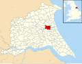 | [2] |
| Brantingham | Civil parish | Beverley Rural District |  | [8] |
| Bridlington | Town | Bridlington Municipal Borough |  | [10] |
| Broomfleet | Civil parish | Howden Rural District | 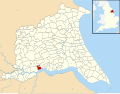 | [5] |
| Bubwith | Civil parish | Howden Rural District |  | [5] |
| Bugthorpe | Civil parish | Pocklington Rural District | 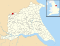 | [3] |
| Burstwick | Civil parish | Holderness Rural District |  | [2] |
| Burton Agnes | Civil parish | Bridlington Rural District | 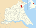 | [7] |
| Burton Constable | Civil parish | Holderness Rural District | 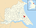 | [2] |
| Burton Fleming | Civil parish | Bridlington Rural District | 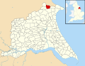 | [7] |
| Burton Pidsea | Civil parish | Holderness Rural District | 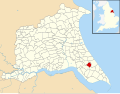 | [2] |
| Carnaby | Civil parish | Bridlington Rural District |  | [7] |
| Catton | Civil parish | Pocklington Rural District | 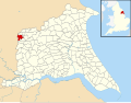 | [3] |
| Catwick | Civil parish | Holderness Rural District |  | [2] |
| Cherry Burton | Civil parish | Beverley Rural District |  | [8] |
| Coniston | Civil parish | Holderness Rural District |  | [2] |
| Cottam | Civil parish | Driffield Rural District |  | [6] |
| Cottingham | Civil parish | Haltemprice Urban District |  | [4] |
| Cottingwith | Civil parish | Pocklington Rural District |  | [3] |
| Dalton Holme | Civil parish | Beverley Rural District |  | [8] |
| Driffield | Town | Driffield Urban District |  | [11] |
| Easington | Civil parish | Holderness Rural District |  | [2] |
| East Garton | Civil parish | Holderness Rural District |  | [2] |
| Eastrington | Civil parish | Howden Rural District |  | [5] |
| Ellerby | Civil parish | Holderness Rural District |  | [2] |
| Ellerker | Civil parish | Beverley Rural District |  | [8] |
| Ellerton | Civil parish | Howden Rural District |  | [5] |
| Elloughton cum Brough | Civil parish | Beverley Rural District |  | [8] |
| Elstronwick | Civil parish | Holderness Rural District |  | [2] |
| Etton | Civil parish | Beverley Rural District |  | [8] |
| Everingham | Civil parish | Pocklington Rural District |  | [3] |
| Fangfoss | Civil parish | Pocklington Rural District |  | [3] |
| Fimber | Civil parish | Driffield Rural District |  | [6] |
| Flamborough | Civil parish | Bridlington Rural District |  | [7] |
| Foggathorpe | Civil parish | Howden Rural District |  | [5] |
| Foston | Civil parish | Driffield Rural District |  | [6] |
| Fridaythorpe | Civil parish | Driffield Rural District |  | [6] |
| Full Sutton | Civil parish | Pocklington Rural District |  | [3] |
| Garton | Civil parish | Driffield Rural District |  | [6] |
| Gilberdyke | Civil parish | Howden Rural District |  | [5] |
| Goodmanham | Civil parish | Pocklington Rural District |  | [3] |
| Goole | Town | Goole Municipal Borough |  | [12] |
| Goole Fields | Civil parish | Goole Rural District |  | [1] |
| Gowdall | Civil parish | Goole Rural District |  | [1] |
| Grindale | Civil parish | Bridlington Rural District |  | [7] |
| Halsham | Civil parish | Holderness Rural District |  | [2] |
| Harpham | Civil parish | Driffield Rural District |  | [6] |
| Hatfield | Civil parish | Holderness Rural District |  | [2] |
| Hayton | Civil parish | Pocklington Rural District |  | [3] |
| Hedon | Town | Hedon Municipal Borough |  | [13] |
| Hessle | Town | Haltemprice Urban District |  | [4] |
| Hollym | Civil parish | Holderness Rural District |  | [2] |
| Holme upon Spalding Moor | Civil parish | Howden Rural District |  | [5] |
| Holmpton | Civil parish | Holderness Rural District |  | [2] |
| Hook | Civil parish | Goole Rural District |  | [1] |
| Hornsea | Town | Hornsea Urban District |  | [14] |
| Hotham | Civil parish | Howden Rural District |  | [5] |
| Howden | Town | Howden Rural District |  | [5] |
| Huggate | Civil parish | Pocklington Rural District |  | [3] |
| Humbleton | Civil parish | Holderness Rural District |  | [2] |
| Hutton Cranswick | Civil parish | Driffield Rural District |  | [6] |
| Kelk | Civil parish | Driffield Rural District |  | [6] |
| Keyingham | Civil parish | Holderness Rural District |  | [2] |
| Kilham | Civil parish | Driffield Rural District |  | [6] |
| Kilpin | Civil parish | Howden Rural District |  | [5] |
| Kirby Underdale | Civil parish | Pocklington Rural District |  | [3] |
| Kirk Ella | Civil parish | Haltemprice Urban District |  | [4] |
| Kirkburn | Civil parish | Driffield Rural District | 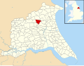 | [6] |
| Langtoft | Civil parish | Driffield Rural District |  | [6] |
| Laxton | Civil parish | Howden Rural District | 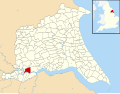 | [5] |
| Leconfield | Civil parish | Beverley Rural District | 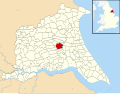 | [8] |
| Leven | Civil parish | Beverley Rural District | 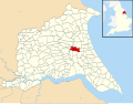 | [8] |
| Lockington | Civil parish | Beverley Rural District |  | [8] |
| Londesborough | Civil parish | Pocklington Rural District |  | [3] |
| Lund | Civil parish | Beverley Rural District |  | [8] |
| Mappleton | Civil parish | Holderness Rural District |  | [2] |
| Market Weighton | Town | Pocklington Rural District |  | [3] |
| Melbourne | Civil parish | Pocklington Rural District |  | [3] |
| Middleton | Civil parish | Driffield Rural District |  | [6] |
| Millington | Civil parish | Pocklington Rural District |  | [3] |
| Molescroft | Civil parish | Beverley Rural District |  | [8] |
| Nafferton | Civil parish | Driffield Rural District |  | [6] |
| Newbald | Civil parish | Beverley Rural District |  | [8] |
| Newport | Civil parish | Howden Rural District |  | [5] |
| Newton on Derwent | Civil parish | Pocklington Rural District |  | [3] |
| North Cave | Civil parish | Howden Rural District |  | [5] |
| North Dalton | Civil parish | Driffield Rural District |  | [6] |
| North Ferriby | Civil parish | Beverley Rural District |  | [8] |
| North Frodingham | Civil parish | Driffield Rural District |  | [6] |
| Nunburnholme | Civil parish | Pocklington Rural District |  | [3] |
| Ottringham | Civil parish | Holderness Rural District |  | [2] |
| Patrington | Civil parish | Holderness Rural District |  | [2] |
| Paull | Civil parish | Holderness Rural District |  | [2] |
| Pocklington | Town | Pocklington Rural District |  | [3] |
| Pollington | Civil parish | Goole Rural District |  | [1] |
| Preston | Civil parish | Holderness Rural District |  | [2] |
| Rawcliffe | Civil parish | Goole Rural District |  | [1] |
| Reedness | Civil parish | Goole Rural District |  | [1] |
| Rimswell | Civil parish | Holderness Rural District |  | [2] |
| Rise | Civil parish | Holderness Rural District |  | [2] |
| Riston | Civil parish | Holderness Rural District |  | [2] |
| Roos | Civil parish | Holderness Rural District |  | [2] |
| Routh | Civil parish | Beverley Rural District |  | [8] |
| Rowley | Civil parish | Beverley Rural District |  | [8] |
| Rudston | Civil parish | Bridlington Rural District |  | [7] |
| Sancton | Civil parish | Pocklington Rural District |  | [3] |
| Seaton | Civil parish | Holderness Rural District |  | [2] |
| Seaton Ross | Civil parish | Pocklington Rural District |  | [3] |
| Shipton Thorpe | Civil parish | Pocklington Rural District |  | [3] |
| Sigglesthorne | Civil parish | Holderness Rural District |  | [2] |
| Skeffling | Civil parish | Holderness Rural District |  | [2] |
| Skerne and Wansford | Civil parish | Driffield Rural District |  | [6] |
| Skidby | Civil parish | Beverley Rural District |  | [8] |
| Skipsea | Civil parish | Bridlington Rural District |  | [7] |
| Skirlaugh | Civil parish | Holderness Rural District |  | [2] |
| Skirpenbeck | Civil parish | Pocklington Rural District |  | [3] |
| Sledmere | Civil parish | Driffield Rural District |  | [6] |
| Snaith and Cowick | Town | Goole Rural District |  | [1] |
| South Cave | Civil parish | Beverley Rural District |  | [8] |
| South Cliffe | Civil parish | Pocklington Rural District |  | [3] |
| Spaldington | Civil parish | Howden Rural District |  | [5] |
| Sproatley | Civil parish | Holderness Rural District |  | [2] |
| Stamford Bridge | Civil parish | Pocklington Rural District |  | [3] |
| Sunk Island | Civil parish | Holderness Rural District |  | [2] |
| Sutton upon Derwent | Civil parish | Pocklington Rural District |  | [3] |
| Swanland | Civil parish | Beverley Rural District |  | [8] |
| Swine | Civil parish | Holderness Rural District |  | [2] |
| Swinefleet | Civil parish | Goole Rural District |  | [1] |
| Thorngumbald | Civil parish | Holderness Rural District | 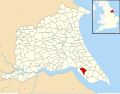 | [2] |
| Thornton | Civil parish | Pocklington Rural District | 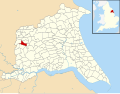 | [3] |
| Thwing | Civil parish | Bridlington Rural District |  | [7] |
| Tibthorpe | Civil parish | Driffield Rural District |  | [6] |
| Tickton | Civil parish | Beverley Rural District | 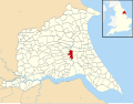 | [8] |
| Twin Rivers | Civil parish | Goole Rural District | 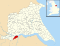 | [1] |
| Ulrome | Civil parish | Bridlington Rural District | 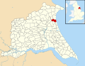 | [7] |
| Walkington | Civil parish | Beverley Rural District |  | [8] |
| Warter | Civil parish | Pocklington Rural District | 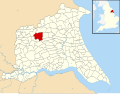 | [3] |
| Watton | Civil parish | Driffield Rural District | 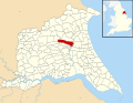 | [6] |
| Wawne | Civil parish | Beverley Rural District | 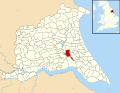 | [8] |
| Welton | Civil parish | Beverley Rural District |  | [8] |
| Welwick | Civil parish | Holderness Rural District |  | [2] |
| Wetwang | Civil parish | Driffield Rural District | 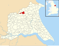 | [6] |
| Wilberfoss | Civil parish | Pocklington Rural District | 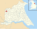 | [3] |
| Willerby | Civil parish | Haltemprice Urban District | 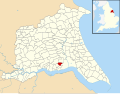 | [4] |
| Withernsea | Town | Withernsea Urban District | 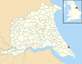 | [15] |
| Withernwick | Civil parish | Holderness Rural District |  | [2] |
| Wold Newton | Civil parish | Bridlington Rural District |  | [7] |
| Woodmansey | Civil parish | Beverley Rural District
Haltemprice Urban District |  | [8]
[4] |
| Wressle | Civil parish | Howden Rural District |  | [5] |
| Yapham | Civil parish | Pocklington Rural District |  | [3] |