See also
| Rivers |  | |
|---|---|---|
| Waterfalls | ||
| Lakes | ||
| Reservoirs | ||
| Glaciers | ||
| Other | ||
The following is a list of coulees located in the province of Alberta, Canada.
| Rivers | | |
|---|---|---|
| Waterfalls | ||
| Lakes | ||
| Reservoirs | ||
| Glaciers | ||
| Other | ||

Milk River is a tributary of the Missouri River, 729 miles (1,173 km) long, in the U.S. state of Montana and the Canadian province of Alberta. Rising in the Rocky Mountains, the river drains a sparsely populated, semi-arid watershed of 23,800 square miles (62,000 km2), ending just east of Fort Peck, Montana.
The Seattle, Lake Shore and Eastern Railway (SLS&E) was a railroad founded in Seattle, Washington, on April 28, 1885, with three tiers of purposes: Build and run the initial line to the town of Ballard, bring immediate results and returns to investors; exploit resources east in the valleys, foothills, Cascade Range, and Eastern Washington in 19th-century style, attracting more venture capital; and boost a link to a transcontinental railroad for Seattle, the ultimate prize for incorporation. The historical accomplishment of the line was Seattle to Sumas at the border, with British Columbia, Canada, connecting with the Canadian Pacific transcontinental at the border at Huntingdon, British Columbia, now part of the City of Abbotsford.

Willmore Wilderness Park, in Alberta, Canada, is a 4,600-square-kilometre (1,800 sq mi) wilderness area adjacent to Jasper National Park. It is lesser known and less visited than Jasper National Park. There are no public roads, bridges or buildings. There are, however, several ranger cabins in the park that are available as a courtesy to visitors.

Cypress Hills Interprovincial Park is a natural park in Canada straddling the Alberta / Saskatchewan boundary and jointly administered by the two provinces. Located south-east of Medicine Hat in the Cypress Hills, it became Canada's first interprovincial park in 1989.

Writing-on-Stone Provincial Park is located about 100 kilometres (60 mi) southeast of Lethbridge, Alberta, Canada, or 44 kilometres (30 mi) east of the community of Milk River, and straddles the Milk River itself. It is one of the largest areas of protected prairie in the Alberta park system, and serves as both a nature preserve and protection for many First Nations (indigenous) rock carvings and paintings. The park is sacred to the Blackfoot and many other aboriginal tribes.

Stirling is a village in southern Alberta, Canada that is surrounded by the County of Warner No. 5. The village is located on Highway 4, approximately 31 km (19 mi) southeast of Lethbridge and 72 km (45 mi) northwest of the Canada–US border.

Big Valley is a village in central Alberta, Canada that is southeast of Red Deer. It is located 32 km (20 mi) south of Stettler and 64 km (40 mi) north of Drumheller on Highway 56 in the County of Stettler No. 6.
Warner is a village in Alberta, Canada. It is surrounded by the County of Warner No. 5, approximately 65 km (40 mi) south of Lethbridge. Warner is a farming community. Warner is situated at the intersection of Highway 4 and Highway 36, about 38 km north of the Montana border and Interstate 15. Warner's nearest neighbours are the towns of Stirling and Milk River.

The Oldman River valley parks system is a continuous collection of eight urban parks in the Oldman River valley of Lethbridge, Alberta, 100 metres (330 ft) below the prairie level. The parks were created in the 1980s as part of the city's Urban Parks Project. Today they are a combined 16 square kilometres (6.2 sq mi) in size and comprise one of the largest urban park systems in North America, and the third largest in Canada.

The Red Coat Trail is a 1,300-kilometre (810 mi) route that approximates the path taken in 1874 by the North-West Mounted Police in their March West from Fort Dufferin to Fort Whoop-Up.

The Atlas Coal Mine National Historic Site is an inactive coal mine in Alberta, Canada that operated from 1936 to 1979. Located in East Coulee near Drumheller, it is considered to be Canada's most complete historic coal mine and is home to the country's last standing wooden coal tipple, and the largest still standing in North America. It was designated an Alberta Provincial Historic Resource in 1989 and a National Historic Site of Canada in 2002.
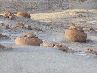
Red Rock Coulee is a Provincial Natural Area in southeastern Alberta, Canada, 54 kilometres (30 mi) south-southwest of the city of Medicine Hat and 26 kilometres (20 mi) south of the hamlet of Seven Persons on Alberta Highway 887. The main feature of this natural landscape is the large spherical reddish boulders (concretions), some of which measure 2.5 metres (8.2 ft) in diameter. They are scattered across the badlands and coulees, and can be seen along the hiking trails, as well as from the viewpoint on Highway 887.
Conrad is a former unincorporated community in the County of Warner No. 5, Alberta, Canada. The population of the community was fairly small and only had around 5 people with two grain elevators. Today nothing remains of the community, but its original location on the historic Red Coat Trail was 8 km (4 mi) east of the Hamlet of Wrentham and about 24 km (14 mi) west of the Village of Foremost. The community was named by the Canadian Pacific Railway.
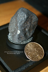
Buzzard Coulee is the collective name of the meteorites fallen on November 20, 2008 over Saskatchewan, Canada.

Birch Coulee Battlefield in Renville County, Minnesota, United States, was the site of the Battle of Birch Coulee, the costliest military engagement for U.S. forces during the Dakota War of 1862. It is now a historic site with self-guided trails and markers interpreting the battle from both sides. Birch Coulee was nominated to the National Register of Historic Places for having state-level significance in military history, and was listed in 1973.
McNab is a former unincorporated community in southern Alberta, Canada within the County of Warner No. 5. It is located on Highway 506 between the Hamlet of New Dayton and the Village of Warner, approximately 50 kilometres (31 mi) southeast of the City of Lethbridge.
Milk River Natural Area is a provincially designated protected area in the southeastern corner of the province of Alberta, Canada, approximately 160 km south of the city of Medicine Hat. It lies primarily in the County of Forty Mile with a small portion in southwest Cypress County. On the Alberta Township System (ATS) grid it is located in portions of Township 1, Range 5 and 6, and Township 2, Range 6, west of the Fourth Meridian.

The Kennedy Coulee is a coulee – a dry gorge or valley – in northern Montana and southern Alberta. Its exposed rocks of the Judith River Formation are a rich source of fossils.