Etzikom Coulee

Last updated
Etzikom Coulee
Location
Country Canada
Physical characteristics
Source 
  locationStirling Lake
  coordinates 49°31′44″N112°32′30″W / 49.52894°N 112.54171°W / 49.52894; -112.54171 (Stirling Lake)
  elevation930 meters (3,050 ft)
Mouth  
  location
Pakowki Lake
  coordinates
49°23′17″N111°05′42″W / 49.38805°N 111.09504°W / 49.38805; -111.09504 (Etzikom Coulee mouth) Coordinates: 49°23′17″N111°05′42″W / 49.38805°N 111.09504°W / 49.38805; -111.09504 (Etzikom Coulee mouth)
  elevation
860 meters (2,820 ft)
Length~110 kilometers (68 mi)

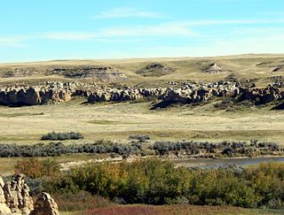
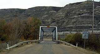
Etzikom Coulee is a coulee located in Southern Alberta, Canada.

Coulee Type of valley or drainage zone

Coulee, or coulée is a term applied rather loosely to different landforms, all of which refer to a kind of valley or drainage zone. The word coulee comes from the Canadian French coulée, from the French word couler meaning "to flow".

Southern Alberta

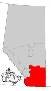
Southern Alberta is a region located in the Canadian province of Alberta. In 2004, the region's population was approximately 272,017. The primary cities are Lethbridge and Medicine Hat. The region is known mostly for agricultural production, but other sectors, such as alternative energy, film production and tourism, are emerging.

Canada Country in North America

Canada is a country in the northern part of North America. Its ten provinces and three territories extend from the Atlantic to the Pacific and northward into the Arctic Ocean, covering 9.98 million square kilometres, making it the world's second-largest country by total area. Its southern border with the United States, stretching some 8,891 kilometres (5,525 mi), is the world's longest bi-national land border. Canada's capital is Ottawa, and its three largest metropolitan areas are Toronto, Montreal, and Vancouver.

Contents

The waterway was formed as a glacial spillway channel at the end of the last ice age. [1]

Ice age Period of long-term reduction in temperature of Earths surface and atmosphere

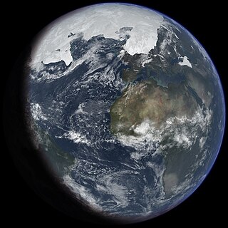
An ice age is a long period of reduction in the temperature of the Earth's surface and atmosphere, resulting in the presence or expansion of continental and polar ice sheets and alpine glaciers. Earth's climate alternates between ice ages and greenhouse periods, during which there are no glaciers on the planet. Earth is currently in the Quaternary glaciation, known in popular terminology as the Ice Age. Individual pulses of cold climate within an ice age are termed "glacial periods", and intermittent warm periods within an ice age are called "interglacials" or "interstadials", with both climatic pulses part of the Quaternary or other periods in Earth's history.

Course

The Etzikom Coulee begins northeast of the town of Stirling, and makes its way southeast of the Hamlet of Wrentham, after that it passes by the Hamlet of Skiff into the Crow Indian Lake, then southeast of the Village of Foremost as well as the Hamlet of Nemiskam, and finally ending south of the Hamlet of Etzikom at Pakowki Lake, the largest lake in Southern Alberta.

Stirling, Alberta Village in Alberta, Canada

Stirling is a village in the County of Warner No. 5, Alberta, Canada. The village is located on Highway 4, approximately 31 km (19 mi) southeast of Lethbridge and 72 km (45 mi) northwest of the Canada–US border.

Wrentham, Alberta Hamlet in Alberta, Canada

Wrentham is a hamlet in southern Alberta, Canada within the County of Warner No. 5. It is located southeast of the intersection of the Veteran Memorial Highway and the historic Red Coat Trail, approximately 25 kilometres (16 mi) east of the Village of Stirling, 30 kilometres (19 mi) south of the Town of Taber and 55 kilometres (34 mi) west of the Village of Foremost.

Skiff, Alberta Hamlet in Alberta, Canada

Skiff is a hamlet in southern Alberta, Canada within the County of Forty Mile No. 8. It is located on Highway 61, also known as the historic Red Coat Trail, approximately 75 km (47 mi) southeast of Lethbridge.

It flows from an elevation of 930 meters (3,050 ft) at its origin east of Stirling Lake (to which it is connected by the Sluice Gate Channel) to an elevation of 860 meters (2,820 ft) at its mouth at Pakowki Lake, over a length of more than 110 kilometers (68 mi). The coulee builds a canyon up to 40 meters (130 ft) deep.

See also

Related Research Articles

Etzikom Hamlet in Alberta, Canada

Etzikom is a hamlet in Alberta, Canada within the County of Forty Mile No. 8. It is approximately 20 kilometres (12 mi) east of Foremost on Highway 61.

New Dayton Hamlet in Alberta, Canada

New Dayton is a hamlet in southern Alberta, Canada within the County of Warner No. 5. It is located on Highway 4 between the villages of Stirling and Warner, approximately 48 kilometres (30 mi) southeast of Lethbridge. New Dayton was named for their former home by settlers from Dayton, Ohio.

Lake Bassano was a proglacial lake that formed in the Late Pleistocene during the deglaciation of south-central Alberta by the impoundment of a re-established drainage system and addition of glacial meltwater. It is associated with the development of through-flowing drainage within the Red Deer River basin in particular, and the South Saskatchewan drainage network in general. Approximately 7,500 square kilometers of the Bassano basin is covered with lacustrine sediments. These sediments are bordered by the topographically higher Buffalo Lake Moraine to the west, the Suffield Moraine to the east and the Lethbridge Moraine to the south.

Milk River Ridge Reservoir is an artificial lake in southern Alberta, Canada. It is located about 44 km (27 mi) south-east of Lethbridge, along Highway 506, west of Highway 4 and is a popular spot for summer activities.

Kipp Coulee is located in Southern Alberta, Canada. It is 8 kilometres southeast of the town of Raymond and starts on the north shore of the Milk River Ridge Reservoir it then makes its way through the Village of Stirling and then it joins the Etzikom Coulee just north east of Stirling.

Conrad, Alberta Place in Alberta, Canada

Conrad is a former unincorporated community in the County of Warner No. 5, Alberta, Canada. The population of the community was fairly small and only had around 5 people with two grain elevators. Today nothing remains of the community, but its original location on the historic Red Coat Trail was 8 km (4 mi) east of the Hamlet of Wrentham and about 24 km (14 mi) west of the Village of Foremost. The community was named by the Canadian Pacific Railway.

Half Moon Lake, Alberta Hamlet in Alberta, Canada

Half Moon Lake is a hamlet in Alberta, Canada within Strathcona County. It is also recognized as a designated place by Statistics Canada under the name of Half Moon Estates. The community is located on the shores of Half Moon Lake, just north of Highway 629, approximately 13 kilometers (8.1 mi) southeast of Sherwood Park.

Foremost Formation

The Foremost Formation is a stratigraphic unit of Late Cretaceous (Campanian) age that underlies much of southern Alberta, Canada. It was named for outcrops in Chin Coulee near the town of Foremost and is known primarily for its dinosaur remains and other fossils.

Belly River river in Canada

Belly River is a river in northwest Montana, United States and southern Alberta, Canada. It is a tributary of the Oldman River, itself a tributary of the South Saskatchewan River.

Pakowki Lake endorheic lake in Alberta, Canada

Pakowki Lake is an endorheic lake in Alberta, Canada located south of Etzikom, Alberta and not far north is the former town site of Pakowki which may have received its name from the lake.

East Coulee, Alberta Former hamlet in Alberta, Canada

East Coulee is a community within the Town of Drumheller, Alberta, Canada. It was previously a hamlet within the former Municipal District (MD) of Badlands No. 7 prior to the MD's amalgamation with the former City of Drumheller on January 1, 1998. It is also recognized as a designated place by Statistics Canada.

Rosebud River river in Canada

The Rosebud River is a major tributary of the Red Deer River in Alberta, Canada.

The Kakisa River is a major tributary of the Mackenzie River in the Northwest Territories of Canada.

The Pakowki Formation is a stratigraphical unit of Campanian age in the Western Canadian Sedimentary Basin.

McNab, Alberta Unincorporated community in Alberta, Canada

McNab is a former unincorporated community in southern Alberta, Canada within the County of Warner No. 5. It is located on Highway 506 between the Hamlet of New Dayton and the Village of Warner, approximately 50 kilometres (31 mi) southeast of the City of Lethbridge.

Pakowki, Alberta unincorporated community in Alberta, Canada

Pakowki is an unincorporated community in Alberta, Canada within the County of Forty Mile No. 8. It is located along Highway 61 in southeast Alberta. It is one of many ghost towns along the historic Red Coat Trail route. Pakowki name originates from nearby Pakowki Lake, about 10 km south. The word "Pakowki" is Blackfoot for "Bad Water".

References

  1. IBA Site Listing. "Pakowki Lake, Foremost, Alberta". Archived from the original on 2011-06-12. Retrieved 2009-05-08.