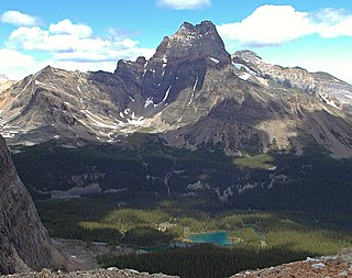
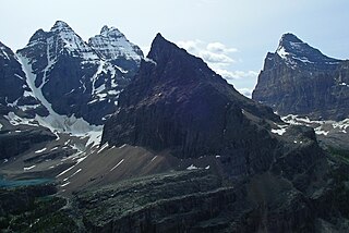
Gallery
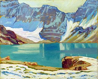
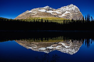
 Kiwetinok Lake


The following is a brief list of some of the major lakes in Yoho National Park. Yoho National Park is one of the major mountain parks in the Canadian Rockies. The region has extraordinary topographical and hydro-graphical features, including significant peaks, waterfalls, lakes, and canyons.


Yoho National Park is a national park of Canada. It is located within the Rocky Mountains along the western slope of the Continental Divide of the Americas in southeastern British Columbia, bordered by Kootenay National Park to the south and Banff National Park to the east in Alberta. The word Yoho is a Cree expression of amazement or awe, and it is an apt description for the park's spectacular landscape of massive ice fields and mountain peaks, which rank among the highest in the Canadian Rockies.
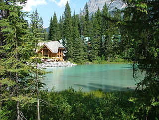
Emerald Lake is located in Yoho National Park, British Columbia, Canada. Yoho National Park is one of the 4 contiguous National Parks in the heart of Canada's Rocky Mountains, along the boundary of British Columbia and Alberta Provinces, the other Parks are Kootenay, Jasper, and Banff. Many Provincial Parks, having near-similar environmental protection and as-spectacular nature, also join these federal reserves. Emerald Lake Lodge, a high-end lodge or hotel, is on a peninsula jutting into the lake. It was founded in the 1920s and completely rebuilt in the 1980s. A quiet 2 lane paved road about 15 km / 9 miles long connects the busy Trans-Canada Highway with Emerald Lake, the exit is well marked. A 5.2 km (3.2 mi) hiking trail circuits the lake, the first half of which is accessible to wheelchairs and strollers, many other more advanced hiking trails go in different directions up into the mountains, be sure to be well prepared in skill, fitness and in hazard awareness before venturing onto them. Many wild animals live in the area and are protected by Park Law, Brown (Grizzly) Bears and Black Bears are fairly common, they co-exist quite well with humans as the Park has strict laws on garbage control and good advice to Park Visitors on practicing bear safety and being "Bear Aware". Mountain Goats and Bighorn Sheep are seen at higher altitudes, and many smaller mammals are common everywhere. Hunting is strictly prohibited in the Park, fishing is permitted with a Park license. During the summer months, canoe rentals are available from the Lodge, in the winter, the lake is a popular cross country skiing destination. Canada's National Parks do not permit private or business land ownership within their boundaries, all development is strictly controlled by the National Park for environmental preservation, development permits are rarely if ever given, and then only after extensive Gov't review and consultation, the land the business occupies is leased from the Park, nearly all businesses in the Parks were established decades ago, and current approval is exceedingly rare. There is a strict "need-to-reside" law in place for living in a Canadian Mountain National Park town or village, simply put you must prove you need to live there for reasons of operating a Park-approved business or service, unless you are a non-management employee. The railway and timber town of Golden BC is the nearest town to Emerald Lake that is outside the Park boundaries, it is about 50 km / 30 miles distant to the west in the low valley of the Columbia River headwaters, and has many lodging options, the small historic railway village of Field is in Yoho Park near the highway exit to Emerald Lake, and has a large Park-operated Information and Visitor's Center, Field Village also has gas, food and a few B & B's. The Park Service Center of Lake Louise, which has limited lodging, is about 30 km / 20 miles to the east of Emerald Lake in neighboring Banff National Park, while the famous resort town of Banff, located on the southeast edge of that Park, is about 60 km / 40 miles further east of Lake Louise, it has a large number of hotels as does the town of Canmore, located just outside the Banff Park boundary. Vehicle / RV campgrounds are common throughout the region for summer use, reservations made well in advance are highly advised for hotels and campgrounds during summer, which is early June to late September on an average weather year. Brief snowstorms, which usually melt in a few days, occasionally occur at valley level in June or September due to the latitude of 53 degrees and the generally high elevation. Daytime temperatures in June or September average 20 C / 70 F, in July and August it can reach as high as 33 C / 90 F. Winter temperatures December to March are always below freezing, averaging -15 C / 0 F and sometimes down to -30 C / -30 F. Snowfall is usually substantial, about 1 meter / 3 feet or more of snow stays at lake level in winter, increasing with altitude to 10 meters / 30 feet or more on the mountain tops.
O'Hara may refer to:
The Stanley Mitchell hut is an alpine hut located at an altitude of 2,060 metres (6,759 ft) in the Little Yoho Valley in Yoho National Park, British Columbia. It sits in a small meadow not far from the base of a mountain called The President. It serves as a base for hiking, scrambling, ski-touring and climbing the nearby mountains. The hut is maintained by the Alpine Club of Canada.
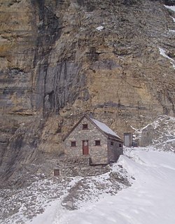
The Abbot Pass hut was an alpine hut located at an altitude of 2,925 metres (9,596 ft) in Abbot Pass in the Rocky Mountains in Alberta, Canada. It was nestled between Mount Victoria and Mount Lefroy, straddling the continental divide, which, in this region, defines the boundary between Banff National Park in Alberta and Yoho National Park in British Columbia. While close to the border, the hut lay entirely in Banff National Park, and was the second-highest permanently habitable structure in Canada. The hut was maintained by the Alpine Club of Canada.

Lake O'Hara is a lake at an elevation of 2,020 metres (6,630 ft) in the alpine area of Yoho National Park, in the province of British Columbia, on the western side of the Great Divide with the province of Alberta and Banff National Park to the east. The lake and the valley are accessible through a bus service that is run by Parks Canada or by an 11 km hike along a road with an elevation gain of approximately 500m.

Mount Lefroy is a mountain on the Continental Divide, at the border of Alberta and British Columbia in western Canada. The mountain is located on the eastern side of Abbot Pass which separates Lake Louise in Banff National Park from Lake O'Hara in Yoho National Park. Mount Victoria lies immediately on the western side of the pass.

Mount Victoria, 3,464 metres (11,365 ft), is a mountain on the border between British Columbia and Alberta in the Canadian Rockies. It is located just northeast of Lake O'Hara in Yoho National Park and is also part of Banff National Park and is on the Continental Divide. The mountain has two peaks, the south being the highest while the north peak is slightly lower at 3,388 metres (11,115 ft).
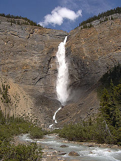
The Little Yoho River is a short river in British Columbia that flows east from Kiwetinok Lake, which is the highest named lake in Canada, and into the Yoho River about 4.4 kilometres (2.7 mi) upstream from the mouth of the creek that Takakkaw Falls is on. It is probably best known for Laughing Falls, an impressive plunge just above the river's mouth that is seen on the way to Twin Falls.

Lake Oesa is a body of water located at an elevation of 2,267 metres (7,438 ft) in the mountains of Yoho National Park, near Field, British Columbia, Canada, while a trail at the far end of the lake leads to Abbot Hut.
Opabin Lake is a body of water located at an elevation of 2,277 metres (7,470 ft) in the mountains of Yoho National Park, near Field, British Columbia, Canada.
Lake McArthur is a lake in Yoho National Park, British Columbia, Canada, near the continental divide.

Mount Biddle is a mountain in British Columbia, Canada.
Odaray Mountain is a 3,137-metre (10,292-foot) summit located west of Lake O'Hara in the Bow Range of Yoho National Park, in the Canadian Rockies of British Columbia, Canada. Its nearest higher peak is Mount Huber, 3.86 km (2.40 mi) to the east. The standard climbing route follows the southeast glacier and ridge starting from Elizabeth Parker hut. Pronunciation sounds like the two words "ode array".
Cathedral Mountain is a 3,189-metre (10,463-foot) complex massif located six kilometres northwest of Lake O'Hara in Yoho National Park, in the Canadian Rockies of British Columbia, Canada. Its shape and structure conjures up a resemblance to a gothic cathedral that has inspired many artists, including Group of Seven's Arthur Lismer, to paint it back in 1928. This picturesque mountain is visible from Highway 1, the Trans-Canada Highway near Kicking Horse Pass. Its nearest higher peak is Mount Stephen, 3.0 km (1.9 mi) to the west. To prevent damage to its operations, CP Rail pumps overflow from Teacup Lake down the west face of Cathedral in order to minimize the subglacial lake's discharging in a phenomenon known as a jökulhlaup.

Michael Peak is a 2,701-metre (8,862-foot) mountain summit located in Yoho National Park, in the Canadian Rockies of British Columbia, Canada. Its nearest higher peak is The President, 4.0 km (2.5 mi) to the west-northwest. Both are part of the President Range which is a subset of the Waputik Mountains. Michael Peak is a landmark seen 4.5 kilometres north-northeast of Emerald Lake, three kilometres southwest of Takakkaw Falls, and 10 kilometres north of Field, British Columbia.

Park Mountain is a 2,951-metre (9,682-foot) mountain summit located above the southwest shore of Lake McArthur in Yoho National Park, in the Bow Range of the Canadian Rockies of British Columbia, Canada. Its nearest higher peak is Mount Biddle, 3.0 km (1.9 mi) to the east. Park Mountain is situated four kilometres west of the Continental Divide, and 12 km (7.5 mi) southeast of Field, British Columbia.
Yukness Mountain is a 2,851-metre (9,354-foot) summit located southeast of Lake O'Hara in the Park Ranges of Yoho National Park, in the Canadian Rockies of British Columbia, Canada. Its nearest higher peak is Ringrose Peak, 1.0 km (0.62 mi) to the east.