List of place names of Dutch origin in Australia

Last updated

The Australian coast known to Dutch explorers until 1644. Note the whole east coast is missing. Thevenot - Hollandia Nova detecta 1644.png
The Australian coast known to Dutch explorers until 1644. Note the whole east coast is missing.

Of an estimated 200 place names the Dutch bestowed on Australian localities in the 17th century as a result of the Dutch voyages of exploration along the western, northern and southern Australian coasts, only about 35 can still be found on current maps. Five out of six names were either renamed or forgotten or their locations were lost. [1] Other places were named after the early Dutch explorers by later British explorers or colonists, for instance the Australian state of Tasmania is named after Abel Tasman. Australia itself was called New Holland by the English and Nieuw Holland by the Dutch.

Contents

Places named by the Dutch

Queensland

The Dutch charted the western side of Cape York Peninsula and the coast of the Gulf of Carpentaria. Willem Janszoon made the first recorded European landfall in Australia during the Janszoon voyage of 1605-6.

Dutch nameEnglish translationDateReason for namingCoordsNotes
Kaap Keerweer Cape Keerweer 1606Meaning "turn-about" cape, the point where the Duijfken turned back North 13°56′00″S141°28′30″E / 13.93333°S 141.47500°E / -13.93333; 141.47500 (Cape Keerweer)
Golf van Carpentaria Gulf of Carpentaria 1623 Pieter de Carpentier, then Governor-General of the Dutch East Indies 13°59′S139°00′E / 13.983°S 139.000°E / -13.983; 139.000 (Gulf of Carpentaria) Situated between the Northern Territory and Queensland
Coen Rivier Coen River 1623 Jan Pieterszoon Coen, previous Governor-General of the Dutch East Indies 13°37′S142°08′E / 13.617°S 142.133°E / -13.617; 142.133 (Coen River) Renamed to Archer River, while its southern tributary (the "South Coen River") retained its name [2]
Staaten Rivier Staaten River 1623Like Staten Island after the Staten-Generaal 16°24′S141°17′E / 16.400°S 141.283°E / -16.400; 141.283 (Staaten River)
Nassau RivierNassau River [3] 1644 Maurice of Nassau, Prince of Orange 15°54′S141°23′E / 15.900°S 141.383°E / -15.900; 141.383 (Nassau River)
Van Diemens BaaiVan Diemen Inlet1644 Anthony van Diemen, then Governor-General of the Dutch East Indies 16°58′S140°59′E / 16.967°S 140.983°E / -16.967; 140.983 (Van Diemen Inlet)
Kaap Van DiemenCape Van Diemen1644 Anthony van Diemen 16°31′S139°42′E / 16.517°S 139.700°E / -16.517; 139.700 (Cape Van Diemen) eastern cape of Mornington Island in the Wellesley Islands

Renamed

Dutch nameCurrent nameDateReason for namingCoordsNotes
Riv. met het Bosch Pennefather River 1606For being a river in the bush 12°13′S141°44′E / 12.217°S 141.733°E / -12.217; 141.733 (Cape York Peninsula) Australia's first recorded place name, intriguingly named after the emblematic "bush"
Carpentaria Cape York Peninsula 1623 ? Pieter de Carpentier 14°S140°E / 14°S 140°E / -14; 140 (Cape York Peninsula)
Van Speult Rivier Jardine River Dutch local governor, Herman van Speult 10°55′S142°12′E / 10.917°S 142.200°E / -10.917; 142.200 (Jardine River)
Batavia Rivier Wenlock River Batavia 12°03′S141°55′E / 12.050°S 141.917°E / -12.050; 141.917 (Wenlock River)

Northern Territory

Dutch nameEnglish translationDateReason for namingCoordsNotes
Kaap ArnhemCape Arnhem and Arnhem Land 1623The ship Arnhem which explored the area. 12°21′S136°58′E / 12.350°S 136.967°E / -12.350; 136.967 (Arnhem Land) The ship was itself named after the city of Arnhem, Gelderland.
Groote Eylandt "Big island"sighted 1623, named 1644 14°00′S136°35′E / 14.000°S 136.583°E / -14.000; 136.583 (Groote Eylandt)
Wesel Eilanden Wessel Islands 1636The ship Klein Wesel or just Wezel, which explored the area. 11°30′S136°25′E / 11.500°S 136.417°E / -11.500; 136.417 (Van Diemen Gulf) The ship was itself named after the city of Wesel, Duchy of Cleves.
Crocodils Eijlandt Crocodile Islands 1644 Saltwater crocodiles 11°53′S135°05′E / 11.883°S 135.083°E / -11.883; 135.083 (Crocodile Islands)
Kaap Van der LijnCape Vanderlin1644 Cornelis van der Lijn, member of the Council of India 15°35′S136°59′E / 15.583°S 136.983°E / -15.583; 136.983 (Cape Vanderlin) Actually the Sir Edward Pellew Group of Islands, the cape name is used for the northern tip of Vanderlin Island
Kaap MariaMaria Island1644Maria Van Aelst, wife of Anthony van Diemen 14°52′S135°44′E / 14.867°S 135.733°E / -14.867; 135.733 (Maria Island) An island, not a cape, in the Limmen Bight, now called Maria Island
Limmen Bocht Limmen Bight 1644The ship Limmen, one of the three ships in Tasman's 1644 expedition. 14°50′S135°34′E / 14.833°S 135.567°E / -14.833; 135.567 (Limmen Bight) The ship was itself named after the town of Limmen, Holland.
Van Diemen Baai Van Diemen Gulf 1644 Anthony van Diemen 12°S132°E / 12°S 132°E / -12; 132 (Van Diemen Gulf)

Western Australia

Dutch nameEnglish translationDateReason for namingCoordsNotes
Dirck Hartogs Ree cap. Dirk Hartog Island 1616 Dirk Hartog 25°50′S113°05′E / 25.833°S 113.083°E / -25.833; 113.083
Dorre EijlandenDorre Island1616Translates to "arid islands" 25°03′S113°06′E / 25.050°S 113.100°E / -25.050; 113.100 to the north of Dirk Hartog Island, appears on 1697-1726 map
Willems Rivier Yardie Creek 1618 Willem Jansz, captain of the Duyfken 22°19′23″S113°48′44″E / 22.32306°S 113.81222°E / -22.32306; 113.81222 Named by captain Lenaert Jacobsz. Jansz was on board, making this his second visit to Australia. [4]
Houtmans Abrolhos Houtman Abrolhos 1619 Frederick de Houtman, various published explanations for "Abrolhos" 28°43′S113°47′E / 28.717°S 113.783°E / -28.717; 113.783
Rottnest Island Rat's Nest Island12/29/1696 Quokkas which appeared to be rats, hence 'rat's nest' 31°59′46″S115°32′28″E / 31.99611°S 115.54111°E / -31.99611; 115.54111 Named by [Tom Preston]
Zwaanenrivier or Swarte Swaene-Rivier Swan River 1/10/1697 Black swans 31°56′50″S115°54′58″E / 31.94722°S 115.91611°E / -31.94722; 115.91611 Named by Willem de Vlamingh
Landt van de Leeuwin Cape Leeuwin Leeuwin (galleon) 34°22′27″S115°08′09″E / 34.37417°S 115.13583°E / -34.37417; 115.13583 Name used for the land in the south west, now name only used for the cape.
Landt van P. Nuyts Nullarbor Pieter Nuyts 32°18′S125°52′E / 32.300°S 125.867°E / -32.300; 125.867 Nuytsland comprised the entire coast adjoining the Great Australian Bight. The name survives in two smaller, separate areas: Nuytsland Nature Reserve and Nuyts Land District.

South Australia

Dutch nameEnglish translationDateReason for namingCoordsNotes
Landt van P. Nuyts Nullarbor 1/16/1627 Pieter Nuyts 32°S132°E / 32°S 132°E / -32; 132 Nuytsland was the given to the coast adjoining the Great Australian Bight.
Eijland St. François St. Francis Island 1627 St. Francis via François Thijssen 32°31′S133°17′E / 32.517°S 133.283°E / -32.517; 133.283
Eijland St. Pieter St. Peter Island 1627 St. Peter via Pieter Pietersen, the head merchant on Thijssen's expedition 32°17′S133°34′E / 32.283°S 133.567°E / -32.283; 133.567

Tasmania

Dutch nameEnglish translationDateReason for namingCoordsNotes
Diemens Land Van Diemen's Land 11/24/1642 Anthony van Diemen 43°35′S146°21′E / 43.583°S 146.350°E / -43.583; 146.350 Now known as Tasmania, after Dutch explorer Abel Tasman
Wits EijlandenDe Witt Island1642 Cornelis Jan Witsen, a VOC Commissioner 43°35′S146°21′E / 43.583°S 146.350°E / -43.583; 146.350
Sweers eijland Sweers Island 1642named after Salomon Sweers, member of the Council of India
Eijland den Maet Maatsuyker Island 12/1/1642named after Joan Maetsuycker, member of the Council of India 43°39′18″S146°16′23″E / 43.65500°S 146.27306°E / -43.65500; 146.27306
Pedra branca 1642"towards noon we passed two rocks of which the westernmost was like Pedra Branca off the coast of China" 43°51′S146°58′E / 43.850°S 146.967°E / -43.850; 146.967 (Pedra branca) Name is Portuguese in origin, although named by the Dutch Tasman
Boreels-eilandBoreel Head11/29/1642 Pieter Boreel, member of the Council of India 43°14′S148°00′E / 43.233°S 148.000°E / -43.233; 148.000 (The Friars) Islands now called The Friars, Boreel Head is now the nearby cape on the south of Bruny Island
Storm Baij Storm Bay 1642"[Tasman] had almost reached his intended anchorage when a heavy storm arose and he was driven out so far to sea that next morning he could hardly discern the land. It was from this incident that Storm Bay got its name." 43°10′S147°33′E / 43.167°S 147.550°E / -43.167; 147.550 (Storm Bay)
Tasmans EijlandTasman Island1642 43°14′S148°00′E / 43.233°S 148.000°E / -43.233; 148.000 (Tasman Island)
Fredericks Hendricks BaijFrederick Hendrick Bay1642 42°51′S147°58′E / 42.850°S 147.967°E / -42.850; 147.967 (Frederick Hendrick Bay) nearby NE cape on Forestier Peninsula still has the name Cape Frederick Hendrick, not near Frederick Henry Bay which is on the other side of the Tasman Peninsula which he never visited. The bay he called Frederick Henry Bay is now Marion Bay
Marias Eijlandt Maria Island 12/4/1642Maria Van Aelst, wife of Anthony Van Diemen 42°37′S148°05′E / 42.617°S 148.083°E / -42.617; 148.083 (Maria Island)
Schoute Eijlandt Schouten Island 12/4/1642 Justus Schouten, member of the Council of India. 42°18′S148°16′E / 42.300°S 148.267°E / -42.300; 148.267 (Schouten Island)
Van der Lijns EijlandVanderlins Island1642 Cornelis van der Lijn, member of the Council of India 42°13′S148°18′E / 42.217°S 148.300°E / -42.217; 148.300 (Freycinet Peninsula) not an island, actually Freycinet Peninsula. When Tasman passed it he was heading east; did not see the connection to the mainland in the north.

Places named after the Dutch

Other places were given Dutch names by later explorers or colonists in honour of the Dutch. These include:

See also

Related Research Articles

<span class="mw-page-title-main">Abel Tasman</span> Dutch seafarer, explorer and merchant (1603–1659)

Abel Janszoon Tasman was a Dutch seafarer and explorer, best known for his voyages of 1642 and 1644 in the service of the Dutch East India Company (VOC).

<span class="mw-page-title-main">European maritime exploration of Australia</span> Overview of the European maritime exploration of Australia

The maritime European exploration of Australia consisted of several waves of European seafarers who sailed the edges of the Australian continent. Dutch navigators were the first Europeans known to have explored and mapped the Australian coastline. The first documented encounter was that of Dutch navigator Willem Janszoon, in 1606. Dutch seafarers also visited the west and north coasts of the continent, as did French explorers.

<span class="mw-page-title-main">Anthony van Diemen</span> Dutch colonial governor (1593–1645)

Anthony van Diemen was a Dutch colonial governor.

<i>Duyfken</i> Dutch ship

Duyfken, also in the form Duifje or spelled Duifken or Duijfken, was a small ship built in the Dutch Republic. She was a fast, lightly armed ship probably intended for shallow water, small valuable cargoes, bringing messages, sending provisions, or privateering. The tonnage of Duyfken has been given as 25-30 lasten.

Willem Janszoon, sometimes abbreviated to Willem Jansz., was a Dutch navigator and colonial governor. Janszoon served in the Dutch East Indies in the periods 1603–1611 and 1612–1616, including as governor of Fort Henricus on the island of Solor. During his voyage of 1605–1606, he became the first European known to have seen the coast of Australia.

Jan Carstenszoon or more commonly Jan Carstensz was a 17th-century Dutch explorer. In 1623, Carstenszoon was commissioned by the Dutch East India Company to lead an expedition to the southern coast of New Guinea and beyond, to follow up the reports of land sighted further south in the 1606 voyages of Willem Janszoon in the Duyfken.

<span class="mw-page-title-main">Zeehan</span> Town in Tasmania, Australia

Zeehan is a town on the west coast of Tasmania, Australia 139 kilometres (86 mi) south-west of Burnie. It is part of the West Coast Council, along with the seaport Strahan and neighbouring mining towns of Rosebery and Queenstown.

<span class="mw-page-title-main">Janszoon voyage of 1605–1606</span> European voyage of discovery to Australia

Willem Janszoon captained the first recorded European landing on the Australian continent in 1606, sailing from Bantam, Java, in the Duyfken. As an employee of the Dutch East India Company, Janszoon had been instructed to explore the coast of New Guinea in search of economic opportunities. He had originally arrived in the Dutch East Indies from the Netherlands in 1598, and became an officer of the VOC on its establishment in 1602.

<span class="mw-page-title-main">Dutch Australians</span> Ethnic group

Dutch Australians refers to Australians of Dutch ancestry. They form one of the largest groups of the Dutch diaspora outside Europe. At the 2021 census, 381,946 people nominated Dutch ancestry, representing 1.5% of the Australian population. At the 2021 census, there were 66,481 Australian residents who were born in the Netherlands.

<span class="mw-page-title-main">Hessel Gerritsz</span> Dutch engraver, cartographer and publisher

Hessel Gerritsz was a Dutch engraver, cartographer, and publisher. He was one of the notable figures in the Golden Age of Netherlandish cartography. Despite strong competition, he is considered by some "unquestionably the chief Dutch cartographer of the 17th century".

Mount Heemskirk is a mountain in Western Tasmania, west of the West Coast Range. It has an elevation of 751 metres (2,464 ft) above sea level. The closest town is Zeehan, about 14 kilometres (9 mi) away.

The Pera and Arnhem were two ships from the Dutch East India Company that explored the north Australian coast in 1623. Arnhem Land is named after the Arnhem while the ship itself was named after the Dutch city Arnhem.

<i>Mauritius</i> (1612)

The Mauritius was an early 17th century Dutch wooden-hulled sailing ship, documented as being in service to the Dutch East India Company between 1618 and 1622.

<span class="mw-page-title-main">Isaack Gilsemans</span> Dutch merchant and artist (c.1606–1646)

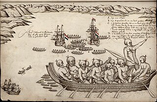
Isaack Gilsemans, was a Dutch merchant, officer of the Dutch East India Company and artist.

<span class="mw-page-title-main">Mount Zeehan</span> Mountain in Tasmania, Australia

Mount Zeehan is a mountain in Western Tasmania, west of the West Coast Range. It has an elevation of 701 metres (2,300 ft) above sea level. The closest town is Zeehan, about 4.93 kilometres (3 mi) away.

<span class="mw-page-title-main">Australia–Netherlands relations</span> Bilateral relations

Bilateral relations exist between Australia and the Netherlands. Australia has an embassy in The Hague. The Netherlands has an embassy in Canberra. The two countries communicate and cooperate on a range of issues, including counterterrorism, climate change, human rights, and the Millennium Development Goals. In 2001 the countries signed an agreement on social security for those who have lived or worked in both countries.

<span class="mw-page-title-main">European exploration of Australia</span> European exploration of Australia

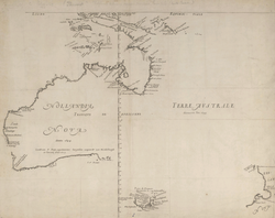
The European exploration of Australia first began in February 1606, when Dutch navigator Willem Janszoon landed in Cape York Peninsula and on October that year when Spanish explorer Luís Vaz de Torres sailed through, and navigated, Torres Strait islands. Twenty-nine other Dutch navigators explored the western and southern coasts in the 17th century, and dubbed the continent New Holland.

Duyfken Point is a point in the locality of Mission River, Shire of Cook, Queensland, Australia.

<i>Heemskerck</i> (1638 ship) Abel Tasmans Flagship

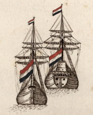
Heemskerck was the flagship of Abel Janszoon Tasman's exploratory voyage of 1642. She and her consort Zeehaen were the first European ships to explore the south coast of Australia, including Tasmania, cross the Tasman Sea, and reach New Zealand among other achievements.

References

  1. Jan Tent, Geographic and Linguistic Reflections on Moent and Dubbelde Ree: Two of Australia’s First Recorded Placenames Archived 26 February 2015 at the Wayback Machine , Geographical Research 44(4):372–385
  2. "December 2007 – Australia on the Map".
  3. Institut, Eingestellt von CID. "Nassau River - Queensland / Australia".
  4. The AOTM Landings List 1606 – 1814 Archived 10 November 2013 at the Wayback Machine

Sources